

What is a Map
A map is a symbolic depiction which denotes relationships between elements of some space such as objects, regions, and themes. Most World Maps are drawn to a scale to express a ratio between two or more units of measurement.The word 'map' originated from the Latin word 'mappa' which meant a napkin or paper. Why so? Because these were the usual materials the earliest maps of the World were drawn on.
Introduction
“A map tells you where you’ve been, where you are, and where you’re going - in a sense it’s three tenses in one.” – Peter GreenawayMaps of the World are as old as our desire to explore; maps give us a sense of being in the world. From the wall paintings in Egypt to the 21st century maps, a lot of learning and unlearning has happened in the process of perfecting the art of representing the world on a two-dimensional surface, thus originating what is known today as World Maps.
The graphical representation of landscape features of an area of the Earth and their symbolic depiction are at the heart of maps of the World. Maps that reflect information other than land area or distance are called Cartograms. General-purpose maps of the World such as atlas maps, and road maps provide different information on a single map.
History of Maps
World Maps emerged out of a necessity and evolved as a mark of progress of a civilization. Cave paintings and rock carvings, dating as early as 12,000 BC, were considered the first maps of the World -like representations that have helped in recognizing landscape features such as mountains, rivers, valleys, and Neolithic towns.To find the earliest specimen of World Maps, one has to refer to the wooden tablets of Babylonia (present-day Iraq) and the land drawings found in Egypt. These two civilizations were among the first to demonstrate their mapping skills of the world.
Much before the Greeks started creating maps of the World, the Babylonians and Egyptians had made several attempts to depict the form and extent of the Earth. However, their objective of mapping was restricted to their local needs. The baton was passed on to the Greeks and Romans who refined the art of map making. Ptolemy's 'Geographia,' was considered a notable work in 150 AD.
After a prolonged lull in the Middle Age, the world got its focus back on World Map-making during the Renaissance period. With the invention of the printing press and the growth of major publishing houses, maps became accessible to all. The establishment of institutions such as the French Academy of Science further gave a boost to map-making process.
The earliest traces of thematic maps could be seen in the late 18th century when maps were produced to record the spread of a particular event, especially spread of disease or the extent of a flood.
Modern maps of the World are drawn based on the borrowed concept that bird's eye view of a landscape is ideal for creating a map. With the exposure to scientific knowledge and understanding of geography, World Maps started becoming more complex and more accurate.
Types of Maps
There are various types of maps of the World and each type presents a different kind of information. World Maps usually include a compass nose to indicate which way is north. They also include a scale so that users can estimate distances. The following is a list of major types of maps of the World with a brief description of what they are about.Climate Maps
A climate map gives generic information about the climate and precipitation in a region. Cartographers use different colors to depict different climate or precipitation zones on the Climate Map. They can also show the specific climatic zones of an area based on the temperature, the amount of snow it receives or the average number of cloudy days.
Economic or Resource Maps
Economic or resource maps attempt to represent the type of natural resources or economic activity predominant in an area through the use of different symbols or colors.
Physical Maps
Physical maps represent the physical features of an area which may include mountains, rivers or lakes. Water bodies are usually shown in blue. Colors are also used to show differences in land elevations. While green is used to depict lower elevations, orange or brown show higher elevations.
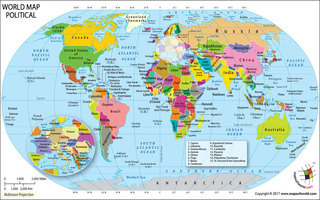
Political Maps
Political maps of the World do not represent any physical or topographical features. They indicate country capitals, major cities and political boundaries including state and national boundaries. Depending on the detail of the World map, they may also include locations of cities, both large and small.
Road Maps
Road maps are one of the most widely used map types. People use them for planning trips and driving directions. Depending on the detail, these maps show major and minor highways and roads besides airports, railroad tracks, city locations and other points of interest such as parks, monuments etc.
Topographic Maps
Topographic Maps feature contour lines to represent the shape and elevation of a particular area. Lines that are close together indicate steep terrain while lines far apart indicate flat terrain. While topographic maps are similar to physical maps in function as they show different physical landscape features, they are different because topographic maps use contour lines, and not colors, to show changes in the landscape.
Thematic Maps
Thematic Maps focus on a particular theme or subject. They are different from the six other types of general reference maps as they do not just show physical or political features such as rivers, cities, roads, elevations or political divisions. These items are only shown as background information and reference points to supplement the particular theme of the map.
Scale of a Map
As World Maps are smaller than the areas they portray, the distances shown on maps of the World are much smaller than the distances on ground that they represent. The relationship between map distance and real distance is called a map’s scale. As is true of any tool or device, correct usage can become a challenge in the absence of proper guidance. The scale of a map simply serves that purpose. A map scale is a ratio of the distance on a World Map to the actual distance of the ground. They are usually mentioned on the outer edge of a map along with the legend. The map scale on most maps is usually a very large ratio as, after all, they are a physical representation of the planet Earth. A 1:100000 scale map for instance means that every 1 cm on the map equals 1 km on the ground.There are two main types of map scales and they are bar and lexical scales. The bar scale is more commonly used. In this, the mapmaker provides a visual guide for making distance calculations. A lexical scale is one in which the mapmaker specifies the distance conversion in words. It is generally considered as less practical and is, therefore, less common.
How to Read a Map
World Maps are the basic tools of geography which represent spatial phenomenon on paper. There are certain rules and conventions one must follow to read a map efficiently. All maps of the World have a legend or key at one corner which specifies what the different symbols used on the map mean. A dashed line, for instance, is often used to represent a border. Map symbols used in one country are often used for different purposes in other countries so it's important to read the legend carefully in order to understand and interpret the symbols correctly.The next important thing to understand a map is interpreting the map scale. As World Maps are representative of a larger portion of the earth, they are drawn to scale. A map scale is a ratio of the distance on a map to the actual distance on the ground. A map needs to provide orientation and it is determined by an arrow pointed in the north direction. All maps of the World have four cardinal directions and they are the north, south, east and west. Some World Maps, including topographic maps, will point to 'true north', that is, the north pole, and to magnetic north where the compass points.
Uses of Maps
World Maps are primarily used to help us find our location and navigate to our desired destination or preferred landmark. The maps of the World aid us to find important places, study and compare different places and also predict the weather. There are many different types of maps, including topographical maps and weather maps, for providing different kinds of information.The first maps were created by hand and made during long and arduous journeys. With time, maps of the World became more and more accurate and today, travelers can get to their destinations in the safest and fastest way possible.
Today, the use of World Maps is not confined to travelers alone. They have become an important tool for research and planning. Maps are used to determine where a communications tower should be located. They are used in urban and regional planning for deciding the location of schools, public facilities, development of highway, and orderly organization of space through zoning and other techniques.
Maps are used as legal documents at national and international levels for testifying the ownership of land and boundaries.


World Maps & Info
- World Map Printable
- World Map for Kids
- World Map showing Country Names in their Native Language
- Black and White World Map
- World Atlas Map
- World Map Games
- Black and White World Map for Kids Room
- World Globe Map - America Centric
- World Globe Map - Africa Centric
- Asia Pacific Map
- World Hemisphere Map
- World Sea Routes Map
- Map of World Largest Dams
- World Map - Major Nuclear Disasters of the World
- World Map - Major Space Centers
- World Map - Major Rail Network
- World Digital Maps
- World GDP Map
Maps in Different Themes
- World War I Map
- Map of Europe during World War I
- World War II Map
- Map of Europe during World War II
- Ancient World Map
- World Population Map
- Map of World Population by 2025 Prediction
- Map of World Population by 2050 Prediction
- World Map - World Popular Festivals
- World Travel Map
- International Country Telephone Calling Codes
- G20 Countries
- Happiest Countries in the World
- Map of World best Shopping Destinations
- Most Haunted Places in the World
- Famous Museums in the World
- Coffee Exporting Countries by Production
- Top Coffee Importing Countries in the World
Environment
- World Geography Map
- World Map of Fault Lines
- World Climate Map
- Map of World Average Temperature in January
- World Weather Map
- Rainforests of the World
- Map of Average Temperature in July
- World Map - River Valley Civilizations
- World Map Precipitation - Rainfall and Snow
- Map of World Wind and Pressure January
- Map of Worldwide Temperatures in July
- Map of Tsunami Zones
- World Map - Tropical Revolving Storm
- Map of World Air Pressure and Wind in July
- Map of Worldwide Temperatures in Jan
- Daylight Saving Time
- Best National Parks
Last Updated on: June 18, 2020