Robinson Projection Map

-
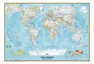
World Classic Wall Map
$23.99
-
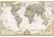
Physical World Wall Map
$16.95
-
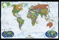
World Decorator Wall Map
$16.95
| Description : The large World Map in Robinson projection showing all the countries with political boundaries. | Disclaimer |
Disclaimer : All efforts have been made to make this image accurate. However MapSherpa, Inc, its directors and employees do not own any responsibility for the correctness or authenticity of the same.
A Robinson projection world map shows the entire world at once, which readily shows the whole globe (including countries, the outline of continents, political boundaries of different countries, oceans, seas, and other details) as a flat image. This projection was devised by Arthur H. Robinson back in 1963 for creating general-purpose world maps. The National Geographic Society (NGS) replaced the earlier Van der Grinten projection in 1988 and started using the world maps in Robinson projection.
There are 195 countries in the world, as per the United Nations. While 193 countries are UN member states, 2 are non-member states (The Vatican or Holy See and the State of Palestine). Most of the countries are located in Africa. 54 countries are situated in the African continent. While 48 countries are located in Asia, 44 countries in Europe, 33 countries in Latin America and the Caribbean, 14 countries in Oceania, 2 countries are located in Northern America.
However, there are 39 territories that are not considered by the United Nations as countries. They are either considered as dependent territories on different countries or disputed territories. While Taiwan is considered to have contentious political status, Western Sahara is considered a disputed territory. The Cook Islands and Niue have a free association with New Zealand. The others are considered territories and dependencies of China, France, the United Kingdom, and New Zealand.
In terms of land area, the list of top 10 largest countries, are:
- Russia: 16,376,870 sq km or 6,323,145 sq mi
- China: 9,388,211 sq km or 3,624,809 sq mi
- USA: 9,147,420 sq km or 3,531,839 sq mi
- Canada: 9,093,510 sq km or 3,511,024 sq mi
- Brazil: 8,358,140 sq km or 3,227,096 sq mi
- Australia: 7,682,300 sq km or 2,966,153 sq mi
- India: 2,973,190 sq km or 1,147,955 sq mi
- Argentina: 2,736,690 sq km or 1,056,642 sq mi
- Kazakhstan: 2,699,700 sq km or 1,042,360 sq mi
- Algeria: 2,381,740 sq km or 919,595 sq mi
The countries can also be classified as the largest in terms of the population too. China and India are the largest countries in terms of population. While China has a population of 1,439,323,776 (18.47% world share), India has a population of 1,380,004,385 (17.70%). The total percentage share of the population living in China and India is 36.17%.
Other countries having the largest population after China and India are the United States of America (USA), Indonesia, Pakistan, Brazil, Nigeria, Bangladesh, Russia, Mexico, and others.
The smallest countries and territories in the world by land area are the Vatican City (the Holy See), Monaco, Nauru, Tuvalu, San Marino, Liechtenstein, Marshall Islands, Saint Kitts & Nevis, Maldives, Malta, Grenada, Saint Vincent & the Grenadines, Barbados, and many more.
Explore all the countries of the world on the world map to get a clear view of the location of continents, countries, oceans, seas, and latitude & longitude. Know the list of countries in the world that are situated on different continents.