logo


Tehama County Map

Below is the County Map of Tehama in California showing the boundaries, roads, highways, towns and much more.
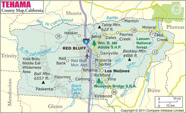
Tehama County Map
Description:Map of Tehama county showing the major towns, highways and much more. Disclaimer
×

Disclaimer  :  All efforts have been made to make this image accurate. However MapSherpa, Inc, its directors and employees do not own any responsibility for the correctness or authenticity of the same.


Inside the page

Facts about Tehama County

County NameTehama County
Founded1856
Area7,670 km2 (2,962 sq mi)
Land Area7,600 km2 (2,950 sq mi)
Water Area30 km2 (12 sq mi)
Population63,463 (2010)
Largest cityRed Bluff
CitiesRed Bluff, Corning, Tehama, Gerber-Las Flores
County SeatRed Bluff
Time zonePacific Standard Time (UTC-8)Summer (DST) Pacific Daylight Time (UTC-7)

Mountain Peaks in Tehama County


Mountain Peak/HillElevation [Meter]
All Top1575
Bald Hill177
Bald Knob453
Ball Mountain1993
Ball Rock2025
Barkley Mountain1364
Bear Den929
Beegum Peak1186
Black Butte240
Black Butte1047
Brokeoff Mountain2810
Brush Mountain1051
Brushy Mountain928
Butt Mountain2395
Campbell Mound709
Christie Hill1996
Colby Mountain1834
Cold Creek Butte1589
Cold Spring Hill1239
Dewitt Peak622
Digger Butte1212
Digger Pine Hill514
Doe Mountain1795
Eagle Peak1128
Elkhorn Peak1583
Finley Butte859
Flatiron Mountain1332
Franklin Point1040
Gleason Peak352
Goat Hill1865
Grays Peak1930
Greasewood Hill833
Gunsight671
Hampton Butte1904
Harvey Peak2221
Humboldt Summit2085
Ice Cave Mountain1824
Ike Dye Hill1338
Inskip Hill931
Iron Mountain982
Jackass Butte587
Lazyman Butte1965
Linn Mount2184
Little Inskip Hill720
Little Red Mountain1487
Lookout Mountain168
Lyons Peak2022
Mineral Summit1606
Morgan Mountain2061
Mount Conard2469
Mount Linn2417
North Star Mountain1725
Onion Butte1771
Onion Summit1698
Oven Lid2021
Owens Butte354
Pattymocus Butte1220
Pinnacle Peak988
Potato Hill372
Promontory Point1094
Raney Peak844
Red Mountain967
Rocky Peak707
Rocky Peak2172
Round Mountain1307
Round Mountain1231
Round Mountain1769
Round Mountain171
Salt Creek Peak646
Ski Hill1578
Soap Butte560
South Yolla Bolly2229
South Yolla Bolly Mountains2452
Stevenson Peak567
Sugarloaf1339
Sugarloaf Mountain757
Sugarloaf Mountain900
Table Mountain363
Table Mountain713
Table Mountain340
Table Mountain169
Tedoc Mountain1563
Tomhead Mountain2019
Turner Mountain2083
Tuscan Buttes563
Twin Peaks2247
Uhl Peak2020
Wells Creek Peak1476
Whitlock Butte420
Williams Butte478


Airports in Tehama County


Airport Name
Corning Municipal Airport
Deer Creek Ranch Airport
Flying N Ranch Airport
Lake California Air Park
Meadow Airstrip
Ponderosa Sky Ranch Airport
Rancho Tehama Airport
Red Bluff Municipal Airport

Cities in Tehama County


CityPopulationLatitudeLongitude
Bend 61940.256027-122.20954
Corning city766339.9282-122.181991
Flournoy 10139.928356-122.446162
Gerber 106040.061443-122.148238
Lake California 305440.360834-122.210244
Las Flores 18740.072141-122.157312
Los Molinos 203740.027055-122.098142
Manton 34740.420191-121.853991
Mineral 12340.375521-121.569397
Paskenta 11239.883275-122.545833
Paynes Creek 5740.340892-121.917409
Proberta 26740.076157-122.177609
Rancho Tehama Reserve 148540.000987-122.441825
Red Bluff city1407640.173462-122.24127
Richfield 30639.973887-122.173305
Tehama city41840.021776-122.126901
Vina 23739.93418-122.051706


Golf Courses in Tehama County


Name of Golf CourseLatitudeLongitude
Oak Creek Golf Course-Red Bluff40.146474-122.224024
Sevillano Links-Corning39.913505-122.202604
Wilcox Oaks Golf Club-Red Bluff40.222263-122.258133

National Parks in Tehama County


Name of ParkLatitudeLongitude 
Lassen Volcanic NP40.494117-121.40578

County Maps of California

Alameda County MapMarin County MapSan Luis Obispo County Map
Alpine County MapMariposa County MapSan Mateo County Map
Amador County MapMendocino County MapSanta Barbara County Map
Butte County MapMerced County MapSanta Clara County Map
Calaveras County MapModoc County MapSanta Cruz County Map
Colusa County MapMono County MapShasta County Map
Contra Costa County MapMonterey County MapSierra County Map
Del Norte County MapNapa County MapSiskiyou County Map
El Doredo County MapNevada County MapSolano County Map
Fresno County MapOrange County MapSonoma County Map
Glenn County MapPlacer County MapStanislaus County Map
Humboldt County MapPlumas County MapSutter County Map
Imperial County MapRiverside County MapTehama County Map
Inyo County MapSacramento County MapTrinity County Map
Kern County MapSan Benito County MapTulare County Map
Kings County MapSan Bernardino County MapTuolumne County Map
Lake County MapSan Diego County MapVentura County Map
Lassen County MapSan Francisco County MapYolo County Map
Los Angeles County MapSan Joaquin County MapYuba County Map
Madera County Map 


Map of Cities in California

Long Beach city MapOakland city MapAnaheim city Map
Santa Ana city MapRiverside city MapStockton city Map
Chula Vista city MapFremont city MapIrvine city Map
San Bernardino city MapModesto city MapOxnard city Map
Los Angeles city Map San Francisco city Map Sacramento city Map
San Jose city Map Bakersfield city Map Fullerton city Map


Last Updated Date: October 27th, 2016