logo


San Diego County Map

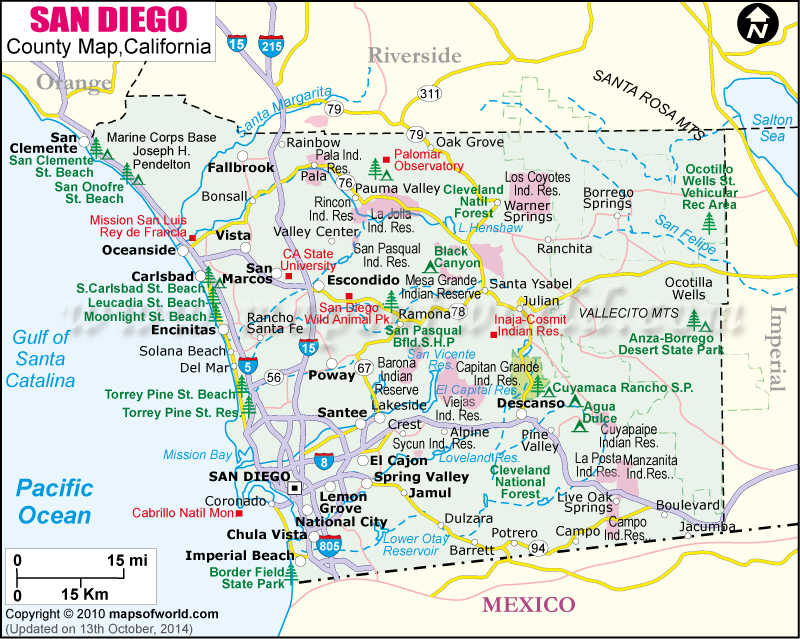
Below is County Map of San Diego in California showing the boundaries, roads, highways, towns and much more.
San Diego County Map Riverside Orange Imperial MEXICO
Description:Map of San Diego county showing the major towns, highways and much more. Disclaimer
×

Disclaimer  :  All efforts have been made to make this image accurate. However MapSherpa, Inc, its directors and employees do not own any responsibility for the correctness or authenticity of the same.


About San Diego County, California


San Diego County lies in the southwestern corner of California state. It is the southwestern-most county in the contiguous United States. With an area of 4,526 square miles, it is the second most populous county in the 'Golden State' and the fifth most populous county in the US. The region was incorporated as a county on February 18, 1850. The city of San Diego is the county seat.


The coastline of San Diego County extends up to 70 miles (110 km) along the Pacific Ocean. The county features the Laguna Mountains and the Sonoran Desert to the far east. Its western region is primarily urban while eastern two-thirds of the county has vast swathes of the backcountry. Southern California culture and seaside communities are prominent in North County and South Bay regions while East County is less suburban in nature. San Diego Bay National Wildlife Refuge and the Tijuana River estuary in South Bay support a variety of wildlife.
Amusement parks like SeaWorld San Diego & Legoland California, San Diego Zoo Safari Park & Balboa Park, museums like Old Town San Diego State Historic Park & USS Midway Museum, and landmarks like Cabrillo National Monument & Mission Basilica San Diego de Alcalá are some of the most visited destinations in San Diego County. La Jolla Cove is one of California's most popular spots for scuba diving, kayaking, and swimming.


How to Reach


San Diego International Airport (SAN) or Lindbergh Field is America's busiest single-runway commercial airport.
Amtrak operates Pacific Surfliner's scenic route through the county.
Interstate 5, I-8, and I-15 pass through major cities in San Diego County.

Facts about San Diego County

County NameSan Diego County
FoundedFeb 18, 1850
Area4,526 sq mi (11,720 km2)
Land Area4,207 sq mi (10,900 km2)
Water Area319 sq mi (830 km2)
Population3,095,313 (2010 Census)
Largest citySan Diego (population and area)
County SeatSan Diego
Time zonePacific Standard Time (UTC-8) Summer (DST) Pacific Daylight Time (UTC-7)

Cities and Towns in San Diego County


CityPopulation
Alpine14,236
Bonita12,538
Bostonia15,379
Camp Pendleton North5,200
Camp Pendleton South10,616
Carlsbad city105,328
Casa de Oro-Mount Helix18,762
Chula Vista city243,916
Coronado city18,912
El Cajon city99,478
Encinitas city59,518
Escondido city143,911
Eucalyptus Hills5,313
Fallbrook30,534
Imperial Beach city26,324
Jamul6,163
La Mesa city57,065
La Presa34,169
Lakeside20,648
Lemon Grove city25,320
National city58,582
Oceanside city167,086
Poway city47,811
Ramona20,292
Rancho San Diego21,208
San Diego Country Estates10,109
San Marcos city83,781
Santee city53,413
Solana Beach city12,867
Spring Valley28,205
Valley Center9,277
Vista city93,834
Winter Gardens20,631


Mountain Peaks in San Diego County


Mountain Peak/HillElevation [Meter]
Agua Tibia Mountain1,454
Aguanga Mountain1,577
Angel Mountain1,385
Barber Mountain985
Barona Mesa562
Battle Mountain233
Bernardo Mountain349
Birch Hill1,737
Black Butte816
Black Mountain474
Black Mountain1,214
Borrego Mountain366
Bottle Peak635
Boucher Hill1,651
Boundary Peak1,195
Breeze Hill117
Bucksnort Mountain1,823
Burnt Mountain632
Camel Rock1,293
Carmel Mountain129
Cerro de la Calavera154
Cerro de las Posas368
Chariot Mountain1,418
Chief Mountain458
Chiquito Peak1,268
Cigarette Hills854
Cigarette Hills842
Combs Peak1,878
Corral Mountain987
Corte Madera Mountain1,412
Cosmit Peak1,394
Cowles Mountain461
Coxey Hill171
Coyote Mountain960
Coyote Peak974
Cranes Peak307
Cuyamaca Peak1,978
Del Mar Mesa124
Devils Anvil Peak477
Dexter Peak1,159
Dictionary Hill324
Donohoe Mountain598
Double Peak496
Dye Mountain1,034
Eagle Crage1,538
Eagle Peak973
East Butte363
East Mesa1,578
East Mesa248
Eastwood Hill1,317
Echo Mountain764
Egg Mountain271
El Cajon Mountain1,112
Elena Mountain1,015
Evans Point107
Fire Mountain93
Fortuna Mountain375
Franks Peak512
French Mountain609
Garnet Mountain1,731
Garnet Peak1,705
Gaskill Peak1,157
Gem Hill1,230
Ghost Mountain1,033
Goat Mountain1,097
Goat Peak514
Gobblers Knob136
Gordon Point1,722
Granite Mountain1,711
Grapevine Mountain1,192
Gray Mountain1,113
Guatay Mountain1,485
Hartley Hill966
Hauser Mountain1,158
Heriot Mountain509
High Point1,851
Hob Nob Hill64
Horno Hill446
Hot Springs Mountain1,989
Indian Head716
Indian Hill686
Indianhead1,194
Inspiration Point371
Iron Mountain818
Jacumba Peak1,025
Jamul Butte425
Japacha Peak1,771
Kearny Mesa156
La Jolla Mesa178
Lancaster Mountain452
Lawson Peak1,099
Lillian Hill966
Little Chief Mountain341
Little Stonewall Peak1,584
Little Tecate Peak714
Loma Alta Mountain146
Lone Fir Point1,463
Long Valley Peak1,473
Lookout Point912
Los Pinos Mountain1,455
Lyons Peak1,139
Margarita Peak956
Marston Point56
Mountain Peak/HillElevation [Meter]
McGinty Mountain652
Metate Hill144
Middle Mesa330
Middle Mountain714
Middle Peak1,795
Miller Mountain886
Mineral Hill1,061
Monkey Hill859
Monkey Hill503
Monserate Mountain472
Monument Peak1,904
Morena Butte1,187
Morgan Hill1,718
Morro Hill280
Mother Grundy Peak927
Mother Miguel Mountain461
Mount Ararat260
Mount Gower946
Mount Helix416
Mount Hinton177
Mount Kelly105
Mount Marron164
Mount Olympus667
Mount Tule1,413
Mount Whitney527
Music Mountain1,087
North Peak1,826
Oakzanita Peak1,530
Old George Mountain1,098
Old Rocky Peak502
Otay Mesa182
Otay Mountain1,067
Pala Mountain636
Palm Mesa1,318
Paradise Mountain710
Parayne Hill1,342
Pi±on Point1,832
Piedras Grandes784
Pine Mountain1,722
Pine Mountain1,284
Pine Mountain1,176
Poser Mountain1,186
Potrero Peak999
Rattlesnake Mountain1,232
Red Hill505
Red Mountain542
Red Mountain487
Red Top986
Red Top1,355
Rock Mountain199
Rock Mountain996
Rocky Mountain1,343
Rocky Peak701
Rodriguez Mountain1,183
Round Granite Hill430
Round Mountain1,014
San Francisco Peak154
San Miguel Mountain780
San Onofre Mountain525
San Vicente Mountain861
San Ysidro Mountain1,869
Santa Ysabel Peak1,452
Sentenac Mountain930
Sheephead Mountain1,793
Sill Hill1,133
Silverdome724
Soledad Mountain249
Sombrero Peak1,274
South Mesa254
Spangler Peak602
Split Mountain414
Spooners Mesa124
Stanley Peak605
Starvation Mountain641
Stephenson Peak1,890
Stonewall Peak1,707
Stuart Mesa40
Sunset Mountain1,113
Sunshine Mountain916
Sycuan Peak840
Table Mountain1,245
Tecate Peak1,183
Teofulio Summit1,122
The Mesa392
The Thimble1,758
Tombstone Peak524
Tourmaline Queen Mountain585
Troutman Mountain609
Twin Peaks399
Van Dam Peak311
Viejas Mountain1,272
Villager Peak1,759
Weaver Mountain463
West Butte366
West Mesa1,459
West Mesa359
Whale Mountain911
Whale Peak1,624
White Mountain989
Wire Mountain94
Witch Creek Mountain991
Wooded Hill1,894
Woodson Mountain878


Airports in San Diego County


Airport Name
Agua Caliente Airport
Blackinton Airport
Borrego Air Ranch Airport
Borrego Valley Airport
Brown Field Municipal Airport
Camp Pendleton MCAS (Munn Field) Airport
Childrens Hospital and Health Center Heliport
Fallbrook Community Airpark
Flying T Ranch Airport
Gillespie Field
Grossmont Hospital Heliport
Hoag Heliport
Hoffman Private Airport
Hunt's Sky Ranch Airport
Imperial Beach Nolf (Ream Fld) Airport
Jacumba Airport
John Nichol's Field Airport
Kgtv-10 Parking Lot Heliport
Lake Wohlford Resort Airport
Landells Heliport
Loma Madera Ranch Airport
Lyall-Roberts Airport
Mc Clellan-Palomar Airport
MCOLF Camp Pendleton (Red Beach) Airport
Mercy Hospital & Medical Center Heliport
Miramar Marine Corps Air Station
Airport Name
Montgomery Field
North Island Naval Air Station-Halsey Field
Oceanside Municipal Airport
Ocotillo Airport
On the Rocks Airport
Paradise Valley Hospital Heliport
Parking Lot Heliport
Pat Coyle Memorial Heliport
Pauma Valley Air Park
Pomerado Hospital Heliport
Qualcomm Building N Heliport
Ramona Airport
Rancho Vallecito Airport
Reider Ranch Airport
San Diego International Airport
San Diego Police Headquarters Heliport
Sce San Onofre Heliport
Sce Songs Mesa Heliport
Scripps Memorial Hospital La Jolla Heliport
Sharp Chula Vista Medical Center Heliport
Torrey Pines Corporate Helistop
Torrey Pines Gliderport
Tri-City Hospital Heliport
Turner Field/Amphibious Base Heliport
U S Naval Hospital San Diego Heliport
Warner Springs Gliderport Airport

Golf Courses in San Diego County


Name of Golf CourseLatitudeLongitude
3 Par At Four Points-San Diego32.810005-117.15043
Admiral Baker Golf Course-San Diego32.792723-117.103797
Arrowood Golf Course-Oceanside33.274351-117.288241
Balboa Park Golf Course-San Diego32.724447-117.136691
Barona Creek Golf Course-Lakeside32.933515-116.869462
Bernardo Heights Country Club-San Diego33.005189-117.071567
Bonita Golf Club-Bonita32.680119-117.015699
Borrego Springs Resort & Country Club-Borrego Springs33.235901-116.357429
Carlton Oaks Country Club-Santee32.842719-117.009671
Carmel Mountain Ranch Country Club-San Diego32.974784-117.076317
Castle Creek Golf Club-Escondido33.25575-117.145014
Center City Golf Course-Oceanside33.197462-117.358265
Chula Vista Municipal Golf Course-Bonita32.661286-117.031867
Colina Park Golf Course-San Diego32.75104-117.083535
Coronado Municipal Golf Course-Coronado32.684808-117.167659
Cottonwood Golf Club-El Cajon32.748314-116.91134
De Anza Desert Country Club-Borrego Springs33.290496-116.384463
Del Mar Country Club-Rancho Santa Fe32.978568-117.195727
Doubletree Golf Resort-San Diego32.978265-117.091142
Eagle Crest Golf Club-Escondido33.116285-117.007417
Eastlake Country Club-Chula Vista32.639487-116.958181
El Camino Country Club-Oceanside33.182594-117.321822
Emerald Isle Golf Course-Oceanside33.215256-117.332191
Encinitas Ranch Golf Course-Encinitas33.068324-117.275501
Escondido Country Club-Escondido33.157101-117.124232
Fairbanks Ranch Country Club-Rancho Sante Fe32.9791-117.206819
Fallbrook Golf Club-Fallbrook33.342525-117.190623
Four Seasons Resort Aviara-Carlsbad33.093277-117.286309
La Costa Resort & Spa-Carlsbad33.092411-117.265783
La Jolla Beach & Tennis Club-La Jolla32.852141-117.260794
La Jolla Country Club-La Jolla32.837455-117.269581
Lake San Marcos Country Club-San Marcos33.124022-117.203977
Lake San Marcos Executive Golf Course-San Marcos33.121423-117.21745
Lomas Santa Fe Country Club-Solana Beach32.995834-117.240739
Lomas Santa Fe Executive Golf Course-Solana Beach32.999456-117.239646
Maderas Golf Club-Poway33.035097-117.022409
Marine Memorial Golf Course-Camp Pendleton33.26824-117.328267
Meadow Lake Golf Course-Escondido33.215505-117.109291
Miramar Memorial Golf Course-San Diego32.885722-117.138227
Mission Bay Golf Resort-San Diego32.798836-117.216405
Mission Trails Golf Course-San Diego32.8015-117.037732
Montesoro Golf and Social Club-Borrego Springs33.193965-116.323788
Morgan Run Resort & Club-Rancho Santa Fe32.991195-117.209306
Mt. Woodson Country Club-Ramona33.01485-116.955599
National City Golf Course-National City32.661119-117.084296
Oaks North Exec. Golf Course-San Diego33.032937-117.057673
Ocean Hills Country Club-Oceanside33.162386-117.267852
Oceanside Golf Course-Oceanside33.25218-117.32179
Pala Mesa Resort-Fallbrook33.355594-117.159798
Palacio Del Mar Golf Course-San Diego32.941935-117.212359
Pauma Valley Country Club-Pauma Valley33.299437-116.988951
Presidio Hills Golf Course-San Diego32.756011-117.197025
Rancho Bernardo Inn Golf Course-San Diego33.029698-117.06698
Rancho Carlsbad Golf Club-Carlsbad33.146683-117.289256
Rancho Monserate Country Club and Homeowners Assoc-Fallbrook33.31737-117.163757
Rancho Santa Fe Golf Club-Rancho Santa Fe33.024761-117.209233
Reidy Creek Golf Course-Escondido33.161259-117.092674
Riverwalk Golf Club-San Diego32.76453-117.170399
Road Runner Golf & Country Club-Borrego Springs33.256848-116.360751
Sail Ho Golf Club-San Diego32.742563-117.210367
San Diego Country Club-Chula Vista32.623277-117.062201
San Luis Rey Downs Golf Resort-Bonsall33.28645-117.213364
San Vicente Inn & Golf Club-Ramona33.002681-116.807212
Sea N Air Golf Course-San Diego32.691736-117.195383
Shadowridge Country Club-Vista33.168235-117.230861
Skyline Ranch Country Club-Valley Center33.207229-116.949513
Springs At Borrego Golf Course-Borrego Springs33.264791-116.365958
Steele Canyon Golf Club-Jamul32.743198-116.894093
StoneRidge Country Club-Poway33.021939-117.038598
Sun Valley Fairways-La Mesa32.770602-117.016036
Sycuan Resort-El Cajon32.786443-116.884866
Tecolote Canyon Golf Course-San Diego32.794943-117.188217
The Auld Course-Chula Vista32.664838-116.95558
The Bridges At Rancho Santa Fe-Rancho Santa Fe33.056989-117.188646
The Country Club of Rancho Bernardo-San Diego33.031087-117.063569
The Crosby National Golf Club-San Diego33.021038-117.151706
The Crossings at Carlsbad-Carlsbad33.126198-117.308598
The Farms Golf Club-Rancho Santa Fe32.985793-117.176845
The Golf Club of California-Fallbrook33.32132-117.201627
The Grand Golf Club-San Diego32.939214-117.197446
The Santaluz Club-San Diego32.992881-117.148278
Torrey Pines Golf Course-La Jolla32.904429-117.243433
Town Park Villas Golf Course-San Diego32.851254-117.19095
Twin Oaks Golf Course-San Marcos33.166897-117.16044
Vineyard At Escondido-Escondido33.073165-117.054074
Vista Valley Country Club-Vista33.247343-117.193445
Warner Springs Ranch-Warner Springs33.282918-116.634395
Welk Resort San Diego-Escondido33.232512-117.141708
Willowbrook Golf Course-Lakeside32.864011-116.938316
Woods Valley Golf Club-Valley Center33.205258-117.014086


National Parks in San Diego County


Name of ParkLatitudeLongitude 
Cabrillo NM32.672529-117.240287

County Maps of California

Alameda County MapMarin County MapSan Luis Obispo County Map
Alpine County MapMariposa County MapSan Mateo County Map
Amador County MapMendocino County MapSanta Barbara County Map
Butte County MapMerced County MapSanta Clara County Map
Calaveras County MapModoc County MapSanta Cruz County Map
Colusa County MapMono County MapShasta County Map
Contra Costa County MapMonterey County MapSierra County Map
Del Norte County MapNapa County MapSiskiyou County Map
El Doredo County MapNevada County MapSolano County Map
Fresno County MapOrange County MapSonoma County Map
Glenn County MapPlacer County MapStanislaus County Map
Humboldt County MapPlumas County MapSutter County Map
Imperial County MapRiverside County MapTehama County Map
Inyo County MapSacramento County MapTrinity County Map
Kern County MapSan Benito County MapTulare County Map
Kings County MapSan Bernardino County MapTuolumne County Map
Lake County MapSan Diego County MapVentura County Map
Lassen County MapSan Francisco County MapYolo County Map
Los Angeles County MapSan Joaquin County MapYuba County Map
Madera County Map