logo


Del Norte County Map

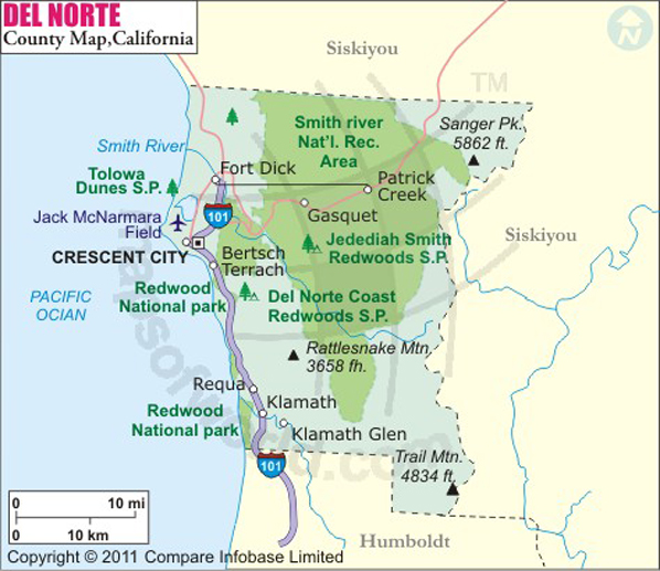
Below is County Map of Del Norte in California showing the boundaries, roads, highways, towns and much more.

Map of Del Norte County, California
Del Norte County Map
Description:Map of Del county showing the major towns, highways and much more. Disclaimer
×

Disclaimer  :  All efforts have been made to make this image accurate. However MapSherpa, Inc, its directors and employees do not own any responsibility for the correctness or authenticity of the same.


Del Norte County, California


Del Norte County is located in the far northwest corner adjacent to the Oregon border in Northern California. Established in 1857, the county spans over an area of 1,230 square miles. The seat and only incorporated city in the county is Crescent City.

Del Norte County has 37 miles of coastline along the Pacific Ocean. Attractions in the county include unique flora, dozens of species of coastal birds and fish, beautiful beaches & sea stacks, pristine rivers, and historical lighthouses. Pelican State Beach – dubbed as “the loneliest beach in California” – is the northern terminus of the California Coastal Trail. Jedediah Smith & Del Norte Coast Redwoods State Park, components of the Redwood National Park, feature old-growth forest of redwoods along the North Coast. The Smith River National Recreation Area offers a variety of recreational opportunities such as camping, fishing, and rafting.

Battery Point Lighthouse, Lake Earl in Tolowa Dunes State Park, Ocean World, and Klamath Tour Thru Tree are points of interest in Del Norte County. Redwood Coast Transit provides local public transit. U.S. Routes 101 and 199 are primary highways in the county. The Crescent City Harbor is used by many commercial fishing vessels.

MOW.DT.01.16.17

Inside the page

Facts about Del Norte County

County NameDel Norte County
Founded1857
Area1,230 sq mi (3,200 km2)
Land Area1,006 sq mi (2,610 km2)
Water Area223 sq mi (580 km2)
Population28,610 (2010)
Largest cityCrescent City
County SeatCrescent City
Time zonePacific Standard Time (UTC-8)Summer (DST) Pacific Daylight Time (UTC-7)

Cities in Del Norte County


CityPopulationLatitudeLongitude
Bertsch-Oceanview 243641.752506-124.158752
Crescent City city764341.77171-124.190801
Gasquet 66141.84289-123.973097
Hiouchi 30141.793664-124.066113
Klamath 77941.53241-124.0075
Smith River 86641.924959-124.14932


Mountain Peaks in Del Norte County


Mountain Peak/HillElevation [Meter]
Bald Hill614
Baldy Peak1750
Barren Butte1326
Bear Basin Butte1578
Bear Cub1835
Black Butte1827
Blue Creek Mountain1475
Broken Rib Mountain1755
Buck Mountain1153
Canthook Mountain816
Chicago Peak1660
Childs Hill713
Cold Spring Mountain1125
Craigs Creek Mountain669
Crazy Peak1566
Footsteps Rocks60
French Hill631
Gasquet Mountain793
Gordon Mountain1240
Hardin Mountain527
Harrington Mountain1736
Haystack1664
Hazel View Summit738
High Dome1065
High Plateau Mountain1060
Howland Hill222
Howland Summit175
Hurdygurdy Butte1598
Jedediah Mountain1759
Kelly Peak790
Laurel Butte917
Little Rattlesnake Mountain974
Little Sanger Peak1611
Lookout Mountain1922
Lower Coon Mountain732
Muslatt Mountain1052
Nickowitz Peak1222
Number Four1561
Number One1585
Number Three1615
Number Two1594
Peak Eight1569
Pigeon Roost979
Pine Flat Mountain806
Polar Bear Mountain1907
Prescott Mountain1734
Rattlesnake Mountain1107
Red Mountain1281
Round Knob550
Sanger Peak1786
Sawtooth Mountain1748
Ship Mountain1619
Signal Peak611
South Red Mountain1205
Stevens Mountain1733
Sugarloaf Mountain884
Table Mountain1433
Twin Peaks1785
Upper Coon Mountain1224
Washington Peak883
Wounded Knee Mountain1419
Youngs Peak1895


Airports in Del Norte County


Airport Name
Andy Mc Beth Airport
Jack Mc Namara Field Airport
Ward Field

Golf Courses in Del Norte County


Name of Golf CourseLatitudeLongitude
Kings Valley Golf Course-Crescent City41.806208-124.139951
Del Norte Golf Club-Crescent City41.830448-124.102347

National Parks in Del Norte County


Name of ParkLatitudeLongitude 
Redwood NP41.387988-124.027356

County Maps of California

Alameda County MapMarin County MapSan Luis Obispo County Map
Alpine County MapMariposa County MapSan Mateo County Map
Amador County MapMendocino County MapSanta Barbara County Map
Butte County MapMerced County MapSanta Clara County Map
Calaveras County MapModoc County MapSanta Cruz County Map
Colusa County MapMono County MapShasta County Map
Contra Costa County MapMonterey County MapSierra County Map
Del Norte County MapNapa County MapSiskiyou County Map
El Doredo County MapNevada County MapSolano County Map
Fresno County MapOrange County MapSonoma County Map
Glenn County MapPlacer County MapStanislaus County Map
Humboldt County MapPlumas County MapSutter County Map
Imperial County MapRiverside County MapTehama County Map
Inyo County MapSacramento County MapTrinity County Map
Kern County MapSan Benito County MapTulare County Map
Kings County MapSan Bernardino County MapTuolumne County Map
Lake County MapSan Diego County MapVentura County Map
Lassen County MapSan Francisco County MapYolo County Map
Los Angeles County MapSan Joaquin County MapYuba County Map
Madera County Map 


Map of Cities in California

Long Beach city MapOakland city MapAnaheim city Map
Santa Ana city MapRiverside city MapStockton city Map
Chula Vista city MapFremont city MapIrvine city Map
San Bernardino city MapModesto city MapOxnard city Map
Los Angeles city Map San Francisco city Map Sacramento city Map
San Jose city Map Bakersfield city Map Fullerton city Map


Last Updated Date: January 16th, 2017