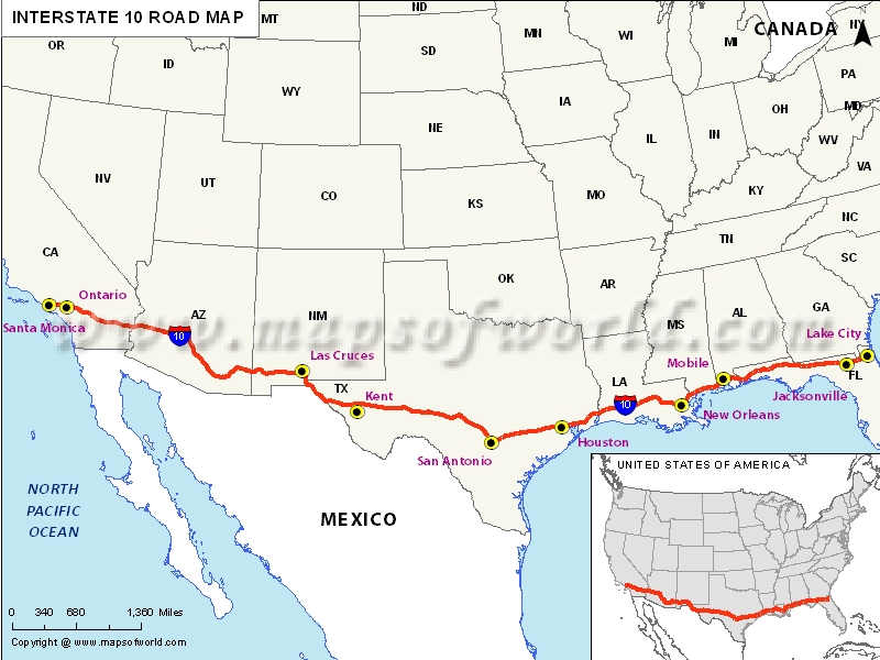
Interstate 10 Map, USA
US Interstate 10 Map

| Description:Map depicts US Interstate 10 (I-10) route from Santa Monica, California to Jacksonville, Florida. | Disclaimer |
×
Disclaimer : All efforts have been made to make this image accurate. However MapSherpa, Inc, its directors and employees do not own any responsibility for the correctness or authenticity of the same.
About US Interstate Highway map
The US interstate highway map shows the Interstate 10 as the southernmost of all the US highways and interstate system. The I-10, as it is commonly abbreviated, connects the East to West and runs from coast to coast. The interstate highway widens from the Pacific Ocean in Santa Monica, the state of California to Jacksonville in Florida. Around the Arizona state, it is necessary for the intending users of this major southern interstate highway to note that several lanes and parallel highways have since been closed. Users should, therefore, expect very slow traffic around the Arizona area. The parts that are severely affected by restrictions, lane reduction, and even lane closure include the Cotton Lane, Sarival Avenue, and Texas Canyon rest areas. The highway users should also be careful around California state areas as the traffic conditions are said to be similar or worse than that of Arizona area.
Attractions along Interstate 10 Highway
There are several gas stations, fast food restaurants, auto repairs centers and tourist attractions located along the US Interstate 10 highway that the users should take note of. Around the 1-10 exit in New Mexico, travelers can enjoy various attractions such as the Gold's Street Gallery, the city of Las Cruces Museum Sys, Mesilla Valley excursions and the famous Mimbres Paquime Connection.
Travelers who might find themselves in problems concerning their automobiles in the California area of the interstate highway can get help from numerous service stations such as Beach Town Car and Limo service, Ukla, A1 limo and town car service among other service stations located along the highway in that area.
Travelers using the interstate 10 highway can also attend to their diets in several top restaurants placed along the major highway in the exits around Texas area. Such restaurants include; Taco Bell, Pine Hurst BBQ, and Senior Torres.
Route of Interstate Highway No.10 |
|---|
| State | Entry Point | Exit Point | Length |
|---|---|---|---|
| California | Santa Monica, CA | Blythe, CA | 2,460.34 mi (3,959.53 km) |
| Arizona | Ehrenberg, AZ | Willcox | 391.99 mi (630.85 km) |
| New Mexico | Lordsburg, NM | Las Cruces | 164.264 mi (264.357 km) |
| Texas | Anthony, TX | Orange | 878.6 mi (1,414.0 km) |
| Louisiana | Toomey, LA | Slidell | 274.42 mi (441.64 km) |
| Mississippi | Diamondhead, MS | Moss Point | 77.056 mi (124.010 km) |
| Alabama | Grand Bay, AL | Perdido River | 66.269 mi (106.650 km) |
| Florida | Pine Forest | Jacksonville | 362.057 mi (582.674 km) |
US Interstates Highways Route Map |
|---|

