logo


Modoc County Map

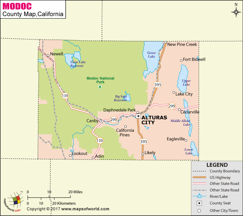
Below is County Map of Modoc in California showing the boundaries, roads, highways, towns and much more.

Map of Modoc County, California
Modoc County Map
Description:Map of Modoc county showing the major towns, highways and much more. Disclaimer
×

Disclaimer  :  All efforts have been made to make this image accurate. However MapSherpa, Inc, its directors and employees do not own any responsibility for the correctness or authenticity of the same.


Inside the page

Facts about Modoc County

County NameModoc County
Founded1874
Area4,203 sq mi (10,890 km2)
Land Area3,918 sq mi (10,150 km2)
Water Area286 sq mi (740 km2)
Population9,686 (2010)
CitiesAlturas, Adin
County SeatAlturas
Time zonePacific Standard Time (UTC-8) Summer (DST) Pacific Daylight Time (UTC-7)

About Map of Modoc County, California


Modoc County
"Where the West still lives" – is located in the far northeast corner of California. Founded in 1874, it is the only county in California that borders both Nevada and Oregon states. Modoc is the third least populous county in the state. The county seat and only incorporated city is Alturas. The rectangular-shaped county is spread over an area of 4,203 square miles.

The Modoc Plateau, an expanse of lava flows and seasonal lakes, spans the northern half of the county. Nearly 1 million acres of the Modoc National Forest covers the land between the Highlands in the west and the Warner Mountains in the east. The southwestern portion of the county features isolated hardwoods and river valleys. The 60-mile-long Surprise Valley features alkaline lakes and forested mountains.

Modoc National Wildlife Refuge, Modoc County Historical Museum, Petroglyph Point in Petroglyph Point, and Fandango Pass are major attractions in Modoc County. U.S. Route 395 and California State Route 299 meet in Alturas and head northeast concurrently.

MOW.DT.01.14.17

Cities and Towns in Modoc County


CityPopulation
Adin272
Alturas city2,827
California Pines520
Canby315
Cedarville514
Daphnedale Park184
Eagleville59
Fort Bidwell173
Lake City61
Likely63
Lookout84
New Pine Creek98
Newell449


Mountain Peaks in Modoc County


Mountain Peak/HillElevation [Meter]
Allen Butte1,392
Bald Mountain1,797
Bald Mountain2,346
Bald Mountain2,518
Bear Mountain2,218
Bearcamp Mountain2,576
Beaver Mountain1,766
Big Sand Butte1,405
Black Butte1,722
Blue Mountain1,746
Buck Mountain2,417
Bump Heads1,383
Carr Butte1,653
Casuse Mountain1,365
Cat Hill1,504
Cedar Mountain2,476
Cole Peak2,723
Coyote Butte1,455
Crank Mountain1,586
Crowder Mountain1,636
Cuppy Butte1,707
Damons Butte1,449
Deer Hill1,475
Deer Hill1,528
Donica Mountain1,510
Double Head Mountain1,686
Dusenbury Peak2,768
Eagle Peak3,016
East Point1,752
East Sand Butte1,361
Egg Lake Butte1,415
Emerson Peak2,724
Fandango Peak2,369
Fleener Butte1,572
Fox Mountain1,943
Grouse Mountain2,111
Happy Camp Mountain1,840
Harper Hill1,512
Harvey Jones Butte1,575
Hermit Butte1,979
Hollenbeck Butte1,385
Horse Mountain2,588
Horse Mountain1,550
Horsehead Mountain1,988
Huffman Butte1,593
Iron Mountain1,759
Jacks Butte1,575
Jimmerson Mountain1,599
Juniper Butte1,279
Kellogg Mountain1,673
Knobcone Butte1,546
Lake Annie Mountain1,830
Little Baldy2,253
Little Horse Mountain1,281
Little Sand Butte1,364
Lone Pine Butte1,508
Lost Hill1,573
Manzanita Mountain2,137
McKay Butte1,629
Mount Bidwell2,529
Mount Vida2,500
Mowitz Butte1,561
Muldoon Mountain1,832
North Mountain1,571
Ostrom Point1,405
Payne Peak2,273
Pilot Butte1,264
Rail Mountain1,650
Rattlesnake Butte1,760
Rattlesnake Butte1,482
Roberts Butte1,313
Round Mountain1,642
Rucker Hill1,543
Sagebrush Butte1,442
Schaffer Mountain1,988
Signal Butte1,419
Smith Butte1,374
South Mountain1,600
Spaulding Butte1,504
Splawn Mountain1,474
Squatty Butte1,425
Stone Coal Mountain1,638
Sugar Hill2,200
Sunflower Knob2,246
Taylor Mountain1,575
The Hat1,336
The Three Sisters1,362
Timber Mountain1,543
Timbered Mountain1,651
Tucker Butte1,580
Twin Sister1,295
Two Buttes1,816
Warren Peak2,950
Washington Mountain1,620
Webb Butte1,459
Westlake Butte1,585
Yellow Mountain2,460


Airports in Modoc County


Airport Name
Alturas Municipal Airport
Bates Field
California Pines Airport
Cedarville Airport
Fort Bidwell Airport
Likely Airport
Tulelake Municipal Airport
Wesinger Ranch Airport
White Pine Heliport

Golf Courses in Modoc County


Name of Golf CourseLatitudeLongitude
Arrowhead Golf Course-Alturas41.500251-120.559643
Likely Links & RV Park-Likely41.234264-120.396731

National Parks in Modoc County


Name of ParkLatitudeLongitude 
Lava Beds NM41.847259-121.387465
Lava Beds NM41.75879-121.516388

County Maps of California

Alameda County MapMarin County MapSan Luis Obispo County Map
Alpine County MapMariposa County MapSan Mateo County Map
Amador County MapMendocino County MapSanta Barbara County Map
Butte County MapMerced County MapSanta Clara County Map
Calaveras County MapModoc County MapSanta Cruz County Map
Colusa County MapMono County MapShasta County Map
Contra Costa County MapMonterey County MapSierra County Map
Del Norte County MapNapa County MapSiskiyou County Map
El Doredo County MapNevada County MapSolano County Map
Fresno County MapOrange County MapSonoma County Map
Glenn County MapPlacer County MapStanislaus County Map
Humboldt County MapPlumas County MapSutter County Map
Imperial County MapRiverside County MapTehama County Map
Inyo County MapSacramento County MapTrinity County Map
Kern County MapSan Benito County MapTulare County Map
Kings County MapSan Bernardino County MapTuolumne County Map
Lake County MapSan Diego County MapVentura County Map
Lassen County MapSan Francisco County MapYolo County Map
Los Angeles County MapSan Joaquin County MapYuba County Map
Madera County Map 


Last Updated Date: September 20th, 2021