logo


Santa Clara County Map

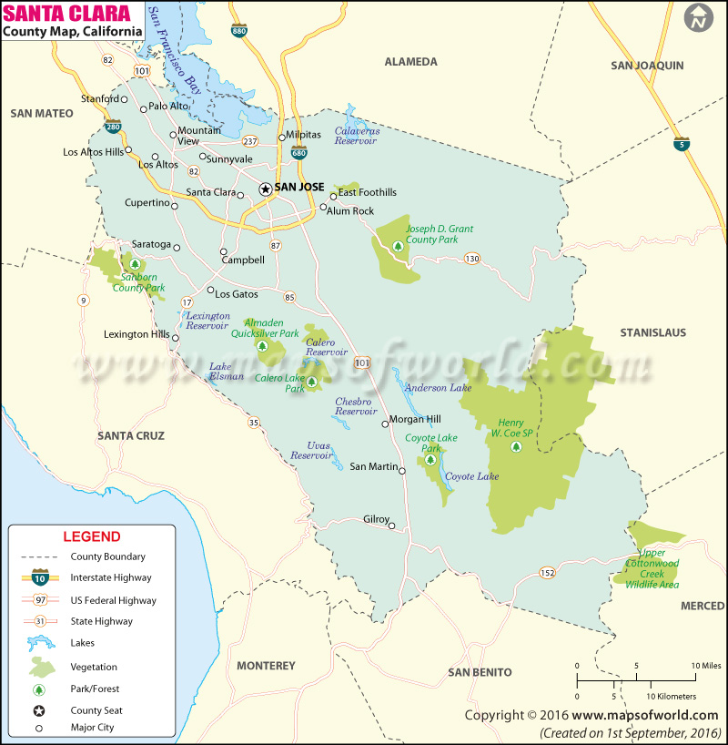
Below is the County Map of Santa Clara in California showing the boundaries, roads, highways, towns and much more.

Map of Santa Clara County, California

Santa Clara County Map
Description:Map of Santa Clara county showing the major towns, highways and much more. Disclaimer
×

Disclaimer  :  All efforts have been made to make this image accurate. However MapSherpa, Inc, its directors and employees do not own any responsibility for the correctness or authenticity of the same.


About Santa Clara County, California


The County of Santa Clara is located at the southern end of the San Francisco Bay in Northern California. The county seat and largest city is San Jose, which is also the tenth most populous city in the United States. The county has an overall area of 1,304 square miles. It is the most populous county in the Bay Area region. The San Andreas Fault runs along the southwest portion of the county.

The South Bay region is synonymous with Santa Clara County and the Valley in general. Santa Clara is one of the richest counties in the US. For being mostly urbanized and prosperous, Santa Clara Valley is also known as Silicon Valley. The valley is home to many of the world's leading high-tech corporations.

California's Great America, Intel Museum, de Saisset Museum, Boomerang Bay, Santa Clara Central Park, and the James Lick Mansion are popular attractions in Santa Clara County. Both Norman Y. Mineta San José International Airport (SJC) and San Francisco International Airport (SFO) serve the county residents. The Santa Clara Station and San Jose Diridon station – a transit hub for Santa Clara County – is served by Caltrain, VTA light rail, ACE, and Amtrak's Coast Starlight & Capitol Corridor routes.

MOW.DT.01.04.17


Inside the page

Facts about Santa Clara County

County NameSanta Clara County
FoundedFeb 18, 1850
Area1,304 sq mi (3,380 km2)
Land Area1,290 sq mi (3,300 km2)
Water Area14 sq mi (40 km2)
Population1,781,642 (2010)
Largest citySan Jose (population and area)
County SeatSan Jose
Time zonePacific Standard Time (UTC-8) Summer (DST) Pacific Daylight Time (UTC-7)

Cities and Towns in Santa Clara County


CityPopulation
Alum Rock15,536
Burbank4,926
Cambrian Park3,282
Campbell city39,349
Cupertino city58,302
East Foothills8,269
Fruitdale935
Gilroy city48,821
Lexington Hills2,421
Los Altos city28,976
Los Altos Hills town7,922
Los Gatos town29,413
Loyola3,261
Milpitas city66,790
Monte Sereno city3,341
Morgan Hill city37,882
Mountain View city74,066
Palo Alto city64,403
San Martin7,027
Santa Clara city116,468
Saratoga city29,926
Stanford13,809
Sunnyvale city140,081


Mountain Peaks in Santa Clara County

         Download PDF  
Mountain Peak/HillElevation [Meter]
Alum Rock565
Baby Peak830
Bald Mountain727
Bald Peaks497
Bear Mountain755
Bills Hill594
Black Mountain855
Black Mountain1,142
Black Mountain1,170
Blossom Hill271
Blue Rocks733
Bollinger Mountain1,045
Brush Mountain872
Burra Burra Peak695
Castle Rock966
Christmas Hill96
Church Hill445
Collords Peak733
Copernicus Peak1,331
Cow Hill987
Coyote Hill111
Coyote Peak351
Crystal Peak1,095
El Sereno769
El Sombroso916
El Toro393
Elephant Head576
Elephant Mountain350
Ewing Hill381
Eylar Mountain1,218
Fern Peak511
Gulnac Peak689
Hagerman Peak539
Kickham Peak712
Lands End776
Larios Peak837
Laurel Hill338
Lions Peak340
Loma Chiquita792
Loma Prieta1,148
Lone Hill82
Lovers Leap311
Masters Hill746
Mine Hill520
Montgomery Hill181
Monument Peak768
Mount Chual1,060
Mount Day1,164
Mount Hamilton1,279
Mount Helen912
Mount Isabel1,278
Mount Lewis1,137
Mount Madonna579
Mount Misery750
Mount Mocho1,117
Mount Sizer976
Mount Stakes1,157
Mount Thayer1,060
Mount Umunhum1,060
Mount Van Lone630
Nibbs Knob806
Nob Hill119
Pacheco Peak816
Panochita Hill574
Pigeon Point486
Pine Springs Hill719
Pyramid Rock1,211
Rattlesnake Butte962
Red Mountain1,115
Rock Springs Peak702
Round Mountain939
Saint Josephs Hill378
Sugarloaf Mountain845
Table Mountain621
Table Mountain565
The Peak913
Tulare Hill173
Twin Peaks453
Vasquez Peak671
Willson Peak807


Airports in Santa Clara County


Airport Name
Canyon Creek Heliport
County Medical Center Heliport
Flea Port Heliport
Mc Candless Towers Heliport
Moffett Federal Airfield
Norman Y. Mineta San Jose International Airport
Regional Medical Center Of San Jose H1 Heliport
Regional Medical Center San Jose H2 Heliport
Reid Hillview of Santa Clara County Airport
South County Airport of Santa Clara County Airport
St Louise Regional Hospital Heliport
Stanford University Hospital Center Heliport

Golf Courses in Santa Clara County


Name of Golf CourseLatitudeLongitude
Almaden Golf & Country Club-San Jose37.214729-121.865566
Blackberry Farm Golf Course-Cupertino37.322918-122.060054
Cinnabar Hills Golf Club-San Jose37.170232-121.757041
CordeValle Golf Club-San Martin37.067913-121.633087
Coyote Creek Golf Club-Morgan Hill37.188773-121.696645
Deep Cliff Golf Course-Cupertino37.312405-122.06556
Eagle Ridge Golf Club-Gilroy37.000636-121.610703
Gavilian Golf Course-Gilroy36.971175-121.56489
Gilroy Golf Course-Gilroy37.011983-121.620391
Golf Club At Boulder Ridge-San Jose37.234587-121.856798
Golf Club Moffett Field-Mountain View37.419509-122.040225
La Rinconada Country Club-Los Gatos37.256633-121.975412
Los Altos Golf & Country Club-Los Altos37.351798-122.090886
Los Lagos Golf Course-San Jose37.301908-121.826983
Palo Alto Hills Golf & Country Club-Palo Alto37.373736-122.170751
Palo Alto Municipal Golf Course-Palo Alto37.452848-122.114858
Pruneridge Golf Club-Santa Clara37.3314-121.963152
Rancho Del Pueblo Golf Course-San Jose37.346509-121.851287
San Jose Country Club-San Jose37.385071-121.815508
San Jose Municipal Golf Course-San Jose37.378113-121.895475
Santa Clara Golf & Tennis Club-Santa Clara37.405796-121.971175
Santa Teresa Golf Club-San Jose37.223684-121.779631
Saratoga Country Club-Saratoga37.285424-122.050179
Shoreline Golf Links-Mountain View37.431567-122.085612
Silver Creek Valley Country Club-San Jose37.27492-121.772166
Spring Valley Golf Course-Milpitas37.444999-121.842525
Stanford University Golf Course-Stanford37.425541-122.185263
Summitpointe Golf Club-Milpitas37.455502-121.881328
Sunken Gardens Municipal Golf Course-Sunnyvale37.355593-122.013993
Sunnyvale Golf Course-Sunnyvale37.395125-122.041499
The Institute LLC-Morgan Hill37.11406-121.591958
The Ranch Golf Club-San Jose37.28808-121.796154
Villages Golf & Country Club-San Jose37.293328-121.75447


Map of Cities in California

Long Beach city MapOakland city MapAnaheim city Map
Santa Ana city MapRiverside city MapStockton city Map
Chula Vista city MapFremont city MapIrvine city Map
San Bernardino city MapModesto city MapOxnard city Map
Los Angeles city Map San Francisco city Map Sacramento city Map
San Jose city Map Bakersfield city Map Fullerton city Map


Last Updated Date: September 20th, 2021