logo


Sutter County Map

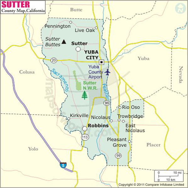
Below is the County Map of Sutter in California showing the boundaries, roads, highways, towns and much more.
Sutter County Map
Description:Map of Sutter county showing the major towns, highways and much more. Disclaimer
×

Disclaimer  :  All efforts have been made to make this image accurate. However MapSherpa, Inc, its directors and employees do not own any responsibility for the correctness or authenticity of the same.


Inside the page

Facts about Sutter County

County NameSutter County
FoundedFeb 18, 1850
Area1,570 km2 (608 sq mi)
Land Area1,560 km2 (602 sq mi)
Water Area16 km2 (6.1 sq mi)
Population94,737 (2010)
CitiesYuba City, Live Oak
County SeatYuba City
Time zonePacific Standard Time (UTC-8) Summer (DST) Pacific Daylight Time (UTC-7)

Mountain Peaks in Sutter County


Mountain Peak/HillElevation [Meter]
Barney Mound10
North Butte557
Old Craggy452
South Butte628
Twin Peaks539
West Butte509

Airports in Sutter County


Airport Name
Bob's Flying Service Inc Airport
Bowles Airport
James Brothers Airport
Lauppes Strip
Moronis Airport
Riego Flight Strip
Sanborn Airport
Scheidel Ranch Airport
Sopwith Farm Airport
Sunrise Dusters Airport
Sutter County Airport
Tenco Tractor Airport
Van Dyke Strip
Vanderford Ranch Company Airport
Vestal Strip
Wagner Aviation Airport


Cities in Sutter County


CityPopulationLatitudeLongitude
East Nicolaus 22538.910021-121.544321
Live Oak city839239.274048-121.665166
Meridian 35839.140437-121.907894
Nicolaus 21138.898092-121.572873
Rio Oso 35638.951756-121.531034
Robbins 32338.867141-121.705556
Sutter 290439.15565-121.74924
Trowbridge 22638.926324-121.514703
Yuba City city6492539.135724-121.637342

Golf Courses in Sutter County


Name of Golf CourseLatitudeLongitude
Mallard Lake Golf Center-Yuba City39.064141-121.633312
Rio La Paz Golf Club-Nicolaus38.881783-121.606045
Southridge Golf Course-Sutter39.157341-121.785472

County Maps of California

Alameda County MapMarin County MapSan Luis Obispo County Map
Alpine County MapMariposa County MapSan Mateo County Map
Amador County MapMendocino County MapSanta Barbara County Map
Butte County MapMerced County MapSanta Clara County Map
Calaveras County MapModoc County MapSanta Cruz County Map
Colusa County MapMono County MapShasta County Map
Contra Costa County MapMonterey County MapSierra County Map
Del Norte County MapNapa County MapSiskiyou County Map
El Doredo County MapNevada County MapSolano County Map
Fresno County MapOrange County MapSonoma County Map
Glenn County MapPlacer County MapStanislaus County Map
Humboldt County MapPlumas County MapSutter County Map
Imperial County MapRiverside County MapTehama County Map
Inyo County MapSacramento County MapTrinity County Map
Kern County MapSan Benito County MapTulare County Map
Kings County MapSan Bernardino County MapTuolumne County Map
Lake County MapSan Diego County MapVentura County Map
Lassen County MapSan Francisco County MapYolo County Map
Los Angeles County MapSan Joaquin County MapYuba County Map
Madera County Map 


Map of Cities in California

Long Beach city MapOakland city MapAnaheim city Map
Santa Ana city MapRiverside city MapStockton city Map
Chula Vista city MapFremont city MapIrvine city Map
San Bernardino city MapModesto city MapOxnard city Map
Los Angeles city Map San Francisco city Map Sacramento city Map
San Jose city Map Bakersfield city Map Fullerton city Map


Last Updated Date: October 27th, 2016