logo


Santa Barbara County Map

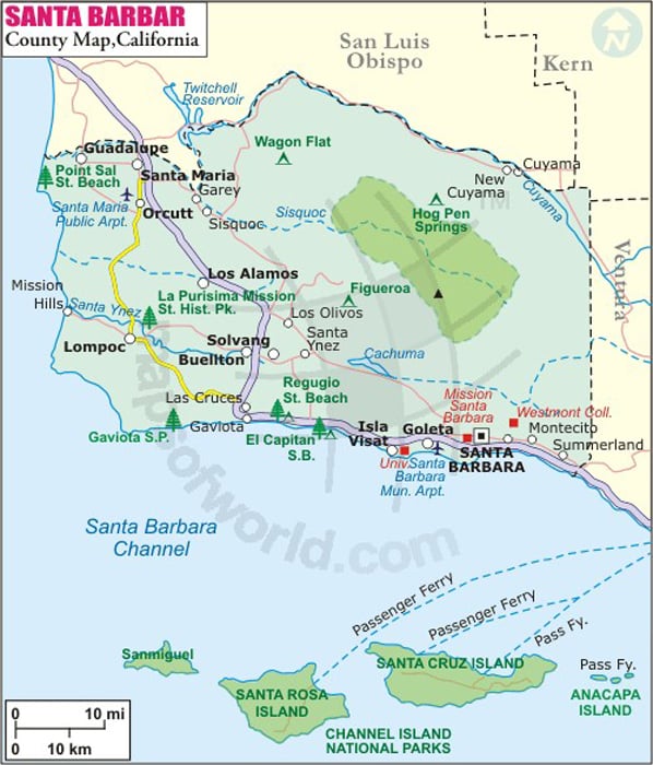
Below is the County Map of Santa Barbara in California showing the boundaries, roads, highways, towns and much more.

Map of Santa Barbara County, California

Santa Barbara County Map
Description:Map of Santa Barbara county showing the major towns, highways and much more. Disclaimer
×

Disclaimer  :  All efforts have been made to make this image accurate. However MapSherpa, Inc, its directors and employees do not own any responsibility for the correctness or authenticity of the same.


Inside the page

Facts about Santa Barbara County

County NameSanta Barbara County
FoundedFeb 18, 1850
Area9,810 km2 (3,789 sq mi)
Land Area7,080 km2 (2,735 sq mi)
Water Area2,730 km2 (1,054 sq mi)
Population423,895 (2010)
Largest citySanta Maria (population) Santa Barbara (area)
County SeatSanta Barbara
Time zonePacific Standard Time (UTC-8) Summer (DST) Pacific Daylight Time (UTC-7)

About Santa Barbara County, California


Santa Barbara is the second largest city and the county seat of Santa Barbara County in Southern California. Situated along the south-facing Pacific coastline, the city is bounded by the Santa Ynez Mountains and the Pacific Ocean. Due to its pleasant, year-round Mediterranean climate, it is often promoted as the 'American Riviera'.


The area was incorporated as a city on April 9, 1850. The city is located about 90 miles (145 km) northwest of Los Angeles.

Places to Visit in Santa Barbara
Nothing is more emblematic of Santa Barbara than red-tiled roofs under crystal-clear skies. The city is renowned as a popular tourist and resort destination among Californians, especially for surfing. Mission Santa Barbara, Stearns Wharf, Santa Barbara Zoo, Botanic Garden, and Casa de la Guerra are some of the most visited attractions in the city.

Acres of unspoilt wilderness of the Los Padres National Forest is only a short drive away from the city. For those willing to have aquatic adventures, beautiful scenery and marine habitats of Channel Islands National Park and Channel Islands National Marine Sanctuary lie roughly 20 miles offshore. The Santa Barbara International Film Festival and annual Summer Solstice Parade draw in thousands of visitors to the city.

How to Reach
  1. By Air- Santa Barbara Municipal Airport (SBA) is served by regional airlines.

  2. By Train- Amtrak operates Coast Starlight and Pacific Surfliner routes through Santa Barbara.

  3. By Road- U.S. Route 101 passes through the downtown area.


Cities and Towns in Santa Barbara County


Mountain Peaks in Santa Barbara County

Mountain Peak/HillElevation [Meter]
Alamar Hill1,099
Alexander Peak1,247
Bald Mountain796
Bald Mountain1,209
Bee Rock636
Big Pine Mountain2,077
Blanca Sierra457
Bone Mountain854
Broadcast Peak1,224
Brush Peak929
Burton Mesa149
Cachuma Mountain1,409
Camelback Hill334
Camuesa Peak962
Cathedral Peak923
Chalk Hill232
Condor Point904
Cuyama Peak1,787
Devils Peak705
Dibblee Hill32
Divide Peak1,384
Figueroa Mountain1,378
Fox Mountain1,569
Gaviota Peak747
Goat Rock838
Green Mountain248
Hildreth Peak1,527
La Cumbre Peak1,210
La Tinta Hill513
Lavigia Hill140
Lions Head138
Little Pine Mountain1,368
Lizard Head1,590
Loma Alta835
Loma Pelona1,359
Lookout Mountain1,044
Los Coches Mountain906
Madulce Peak1,993
Manzanita Mountain957
Mountain Peak/HillElevation [Meter]
McKinley Mountain1,887
McPherson Peak1,748
Miranda Pine Mountain1,259
Monte Arido1,831
Montecito Peak967
More Mesa116
Mount Lospe502
Mount Solomon411
Newlove Hill385
Noon Peak1,212
Oak Mountain612
Old Man Mountain1,664
Ortega Hill77
Palo Alto Hill416
Peak Mountain1,773
Plowshare Peak1,187
Porter Peak1,032
Promontory35
Ranger Peak1,376
Redrock Mountain599
Round Hill76
Sage Hill719
Samon Peak1,840
San Rafael Mountain1,973
Santa Cruz Peak1,687
Santa Rosa Hills488
Santa Ynez Peak1,308
Shephard Mesa208
Sierra Pablo341
Snowball Mountain513
Sudden Peak643
Tepusquet Peak982
Timber Peak1,452
Tranquillon Mountain628
Treplett Mountain1,165
Wheat Peak712
Wild Horse Peak494
Zaca Peak1,312


Airports in Santa Barbara County

Airport Name
Christy AirstripPlatform Hidalgo Heliport
Crawford AirportPlatform Hillhouse Heliport
Elwood Onshore Facility HeliportPlatform Holly Heliport
Goleta Valley Community Hospital HeliportPlatform Ocs P-0188 Hondo Heliport
Lompoc AirportSanta Barbara Municipal Airport
Marian Medical Center HeliportSanta Cruz Island Airport
New Cuyama AirportSanta Maria Pub/Capt G Allan Hancock Field
Northside AirparkSanta Ynez Airport
Platform Harvest HeliportShepherd Ranch Airport
Platform Henry HeliportTexaco Platform Habitat Heliport
Platform Hermosa HeliportVandenberg Air Force Base

Golf Courses in Santa Barbara County


Name of Golf CourseLatitudeLongitude
Alisal Guest Ranch-Solvang34.560797-120.141915
Birnam Wood Golf Club-Santa Barbara34.434834-119.611188
Glen Annie Golf Club-Goleta34.449445-119.876867
Hidden Oaks Golf Course-Santa Barbara34.428665-119.789209
La Cumbre Country Club-Santa Barbara34.434959-119.75539
La Purisima Golf Course-Lompoc34.6648-120.386232
Marshallia Ranch Golf Course-Vandenburg AFB34.789756-120.556934
Montecito Country Club-Santa Barbara34.425913-119.654458
Ocean Meadows Golf Course-Goleta34.422385-119.87081
Rancho Maria Golf Club-Santa Maria34.874907-120.479049
Rancho San Marcos Golf Course-Santa Barbara34.544893-119.877073
River Course at Alisal-Solvang34.588177-120.141517
Sandpiper Golf Course-Santa Barbara34.429747-119.901822
Santa Barbara Golf Club-Santa Barbara34.437878-119.737315
Santa Maria Country Club-Santa Maria34.90538-120.440731
Sunset Ridge Golf Course-Santa Maria34.913372-120.461562
Twin Lakes Golf Course-Goleta34.435998-119.831574
Valley Club of Montecito-Santa Barbara34.439288-119.614992
Village Country Club-Lompoc34.710523-120.456463
Zaca Creek Golf Course-Buellton34.609701-120.19849

National Parks in Santa Barbara County


Name of ParkLatitudeLongitude 
Channel Islands NP34.01406-119.7445
Channel Islands NP34.037806-120.370426
Channel Islands NP34.058207-120.332459
Channel Islands NP34.054788-120.436764
Channel Islands NP34.055286-119.920565
Channel Islands NP34.053713-119.566765
Channel Islands NP33.966568-120.103769
Channel Islands NP34.027893-120.451736
Channel Islands NP33.950604-119.824667

County Maps of California


Map of Cities in California

Long Beach city MapOakland city MapAnaheim city Map
Santa Ana city MapRiverside city MapStockton city Map
Chula Vista city MapFremont city MapIrvine city Map
San Bernardino city MapModesto city MapOxnard city Map
Los Angeles city Map San Francisco city Map Sacramento city Map
San Jose city Map Bakersfield city Map Fullerton city Map


Last Updated Date: September 20th, 2021