logo


Merced County Map

Below is County Map of Merced in California showing the boundaries, roads, highways, towns and much more.

Map of Merced County, California
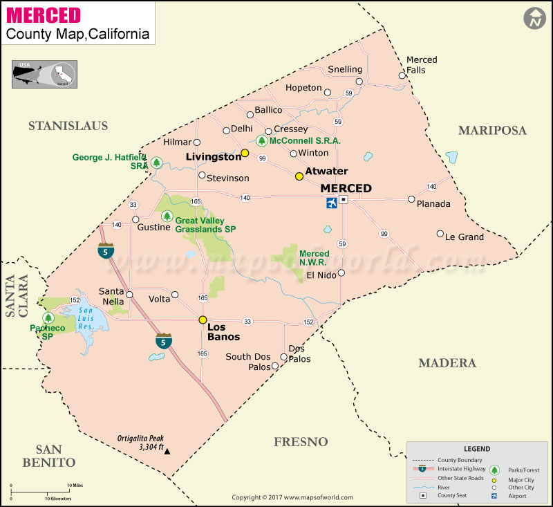
Merced County Map Stanislaus County Santa Clara County San Benito County Fresno County Madera County Mariposa County
Description:Map of Merced county showing the major towns, highways and much more. Disclaimer
×

Disclaimer  :  All efforts have been made to make this image accurate. However MapSherpa, Inc, its directors and employees do not own any responsibility for the correctness or authenticity of the same.


Inside the page

Facts about Merced County

County NameMerced County
Founded1855
Area1,979 sq mi (5,130 km2)
Land Area1,935 sq mi (5,010 km2)
Water Area44 sq mi (110 km2)
Population255,793 (2010)
County SeatMerced
Time zonePacific Standard Time (UTC-8)Summer (DST) Pacific Daylight Time (UTC-7)

Cities and Towns in Merced County


CityPopulation
Atwater city28,168
Ballico406
Bear Creek290
Cressey394
Delhi10,755
Dos Palos city4,950
Dos Palos Y323
El Nido330
Franklin6,149
Gustine city5,520
Hilmar-Irwin5,197
Le Grand1,659
Livingston city13,058
Los Banos city35,972
McSwain4,171
Merced city78,958
Planada4,584
Santa Nella1,380
Snelling231
South Dos Palos1,620
Stevinson313
Volta246
Winton10,613


Mountain Peaks in Merced County


Mountain Peak/HillElevation [Meter]
Basalt Hill519
Bullard Mountain707
Cathedral Peak1021
China Hat208
Haystack Mountain137
Lookout Mountain539
Mariposa Peak1003
Mount Ararat981
Ortigalita Peak993
Red Hill709
Saint Marys Peak745
Spikes Peak585
Sugarloaf857
Sweeney Hill662
Table Top Mountain199
Twin Peaks780


Airports in Merced County


Airport Name
Ahlem Farms Airport
Bonanza Hills Airport
Castle Airport
Emmett Field
Flying M Ranch Airport
Gustine Airport
Hunt Farms Airport
John Myers Airport
Johnson Ranch Airport
Los Banos Municipal Airport
Merced Regional Macready Field
Mercy Medical Center Merced Heliport
San Luis Reservoir Seaplane Base
Stevinson Strip
Turlock Municipal Airport
Willis Ranch Airport

Golf Courses in Merced County


Name of Golf CourseLatitudeLongitude
Fore Bay Golf Course-Santa Nella37.101641-121.01706
Merced Golf & Country Club-Merced37.38039-120.450243
Rancho Del Rey Golf Club-Atwater37.339434-120.581622
Stevinson Ranch Golf Club-Stevinson37.326769-120.832827
Turlock Golf & Country Club-Turlock37.44229-120.830883


County Maps of California

Alameda County MapMarin County MapSan Luis Obispo County Map
Alpine County MapMariposa County MapSan Mateo County Map
Amador County MapMendocino County MapSanta Barbara County Map
Butte County MapMerced County MapSanta Clara County Map
Calaveras County MapModoc County MapSanta Cruz County Map
Colusa County MapMono County MapShasta County Map
Contra Costa County MapMonterey County MapSierra County Map
Del Norte County MapNapa County MapSiskiyou County Map
El Doredo County MapNevada County MapSolano County Map
Fresno County MapOrange County MapSonoma County Map
Glenn County MapPlacer County MapStanislaus County Map
Humboldt County MapPlumas County MapSutter County Map
Imperial County MapRiverside County MapTehama County Map
Inyo County MapSacramento County MapTrinity County Map
Kern County MapSan Benito County MapTulare County Map
Kings County MapSan Bernardino County MapTuolumne County Map
Lake County MapSan Diego County MapVentura County Map
Lassen County MapSan Francisco County MapYolo County Map
Los Angeles County MapSan Joaquin County MapYuba County Map
Madera County Map 


Map of Cities in California

Long Beach city MapOakland city MapAnaheim city Map
Santa Ana city MapRiverside city MapStockton city Map
Chula Vista city MapFremont city MapIrvine city Map
San Bernardino city MapModesto city MapOxnard city Map
Los Angeles city Map San Francisco city Map Sacramento city Map
San Jose city Map Bakersfield city Map Fullerton city Map


Last Updated Date: September 20th, 2021