logo


San Francisco County Map

Below is County Map of San Francisco in California showing the boundaries, roads, highways, towns and much more.

Map of San Francisco County, California
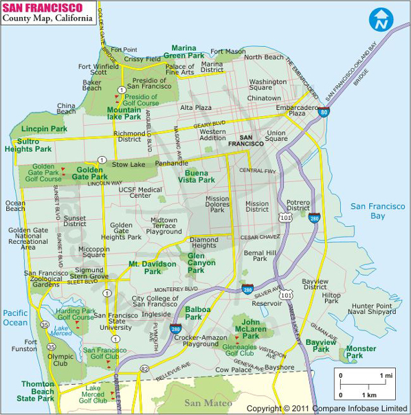
San Francisco County Map
Description:Map of San Francisco county showing the major towns, highways and much more. Disclaimer
×

Disclaimer  :  All efforts have been made to make this image accurate. However MapSherpa, Inc, its directors and employees do not own any responsibility for the correctness or authenticity of the same.


San Francisco County in California


The City and County of San Francisco is the only consolidated city-county in the state of California. With about 47.9 square miles in area, San Francisco is the smallest county in the state. San Francisco is the fourth most populous city in the state. It is located at the north end of the San Francisco Peninsula in Northern California. The city and its surrounding suburbs or cities are collectively known as the San Francisco Bay Area.


Several picturesque islands are part of the city including the Alcatraz, Treasure Island, Yerba Buena Island, and Red Rock Island. The tallest hill in San Francisco is Mount Davidson, at 283 meters and is capped with a 31-m-tall cross. Besides the iconic Golden Gate Bridge, San Francisco is renowned for the cradle of counterculture, the Sexual Revolution, and the Peace Movement. The city is known as a center of liberal activism and a blanket of fog in cool summers hanging over the steep rolling hills rising from the blue Pacific. The city has earned several nicknames like "The City by the Bay", "Fog City", "San Fran", and more.

Cable cars carry riders up the steep inclines of Nob Hill, and down to the waterfront attractions like Fisherman's Wharf and Pier 39, where tourist dine on famous Dungeness crab fresh off the boat. Chinatown in San Francisco is the oldest and surely the most liveliest Chinatown in North America. The Haight-Ashbury is dotted with expensive boutiques for shopping and while retaining its signature bohemian character. The Castro District or, as the locals call it, The Castro neighborhood in Eureka Valley is the epicenter of LGBT activism in America and the world.

MOW.DT.01.03.16


Inside the page

Facts about San Francisco County

County NameSan Francisco County
FoundedJun 29, 1776
Area231.9 sq miles (600.6 km²)
Land Area46.87 sq mi (121.4 km2)
Water Area185.02 sq mi (479.2 km2)
Population837,442 (2013)
Time zonePacific Standard Time (UTC-8)Summer (DST) Pacific Daylight Time (UTC-7)

Cities in San Francisco County


CityPopulationLatitudeLongitude
San Francisco City80523537.759715-122.693976

Airports in San Francisco County


Airport Name
Alcatraz Heliport
Commodore Heliport
Hall of Justice Heliport
Police Pistol Range Heliport
San Francisco Va Medical Center Heliport

Mountain Peaks in San Francisco County


Mountain Peak/HillElevation [Meter]
Bay View Hill124
Bernal Heights139
Buena Vista Heights166
Ignatius Heights104
Lone Mountain126
Lone Mountain121
Main Top68
Mount Davidson278
Mount Olympus169
Mount Sutro278
Nob Hill107
Potrero Hill95
Presidio Hill121
Rincon Hill32
Rob Hill115
Russian Hill102
Stony Hill82
Strawberry Hill129
Telegraph Hill87
Tower Hill68
Twin Peaks280
Visitacion Knob159


Golf Courses in San Francisco County


Name of Golf CourseLatitudeLongitude
Gleneagles Int'l Golf Course-San Francisco37.714377-122.424393
Golden Gate Golf Course-San Francisco37.7699-122.507821
Harding Park Municipal Golf Course-San Francisco37.723584-122.495525
Lincoln Park Golf Course-San Francisco37.781505-122.492784
Presidio Golf Course-San Francisco37.790746-122.458859
San Francisco Golf Club-San Francisco37.712645-122.477501

National Parks in San Francisco County


Name of ParkLatitudeLongitude 
Golden Gate NRA37.822823-122.412712
Golden Gate NRA37.764973-122.498189
Presidio37.783899-122.465358
San Francisco Maritime NHP37.808356-122.422417


Map of Cities in California

Long Beach city MapOakland city MapAnaheim city Map
Santa Ana city MapRiverside city MapStockton city Map
Chula Vista city MapFremont city MapIrvine city Map
San Bernardino city MapModesto city MapOxnard city Map
Los Angeles city Map San Francisco city Map Sacramento city Map
San Jose city Map Bakersfield city Map Fullerton city Map


Last Updated Date: January 06th, 2017