logo


Ventura County Map

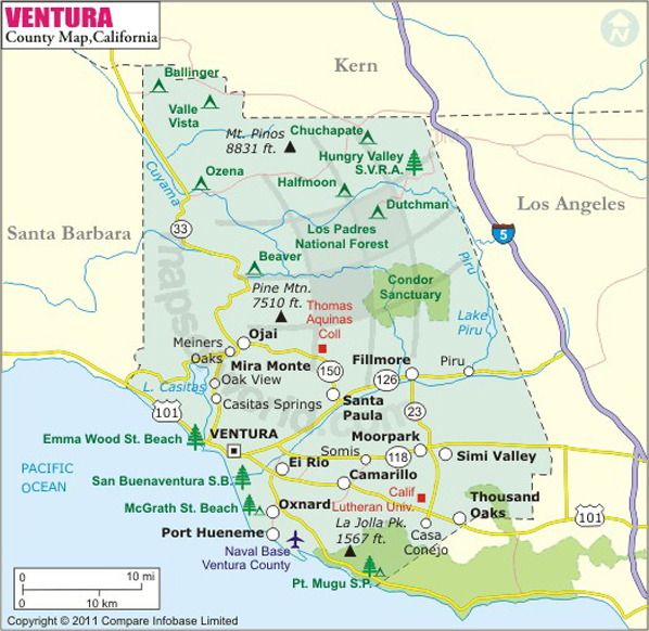
Below is the County Map of Ventura in California showing the boundaries, roads, highways, towns and much more.
Ventura County Map Kern Los Angeles Santa Barbara
Description:Map of Ventura county showing the major towns, highways and much more. Disclaimer
×

Disclaimer  :  All efforts have been made to make this image accurate. However MapSherpa, Inc, its directors and employees do not own any responsibility for the correctness or authenticity of the same.


Founded in 1872, Ventura County is located in Southern California. It covers a total area of 2,208 square miles. Ventura is considered the southernmost county along the Central Coast of California. The county seat is Ventura and the most populous city is Oxnard.

Major physical features in the county include the Oxnard Plain, Santa Clara River Valley, Santa Ynez Mountains, and Santa Monica Mountains. North of Highway 126, the region is mountainous and mostly uninhabited, unspoiled, and rugged wilderness which mainly lies in the Los Padres National Forest. The Conejo Grade highway divides the county in East and West regions. Communities in East County include Thousand Oaks, Oak Park, Simi Valley, and Moorpark. West County, region west of the Conejo Grade, comprises communities of Camarillo, Oxnard, Fillmore, and Ventura.
Emma Wood State Beach, Oxnard Beach Park, and San Buenaventura State Beach are popular haunts for surfing, swimming, and fishing. Only 12 miles from the coast, Anacapa Island in Channel Islands National Park is an ideal spot for day-trips to enjoy scuba diving and overnight camping. Mission San Buenaventura, Conejo Valley, Stagecoach Inn in Newbury Park, and Carnegie Art Museum are other famous attractions in Ventura County.


How to Reach

Los Angeles International Airport (LAX) is within two-hour driving distance from the county.
Amtrak operates Pacific Surfliner and Coast Starlight through Ventura County.
The Ventura Freeway (US 101) is the primary highway traversing the county.

Facts about Ventura County

County NameVentura County
Founded1873
Area2,208 sq mi (5,720 km2)
Land Area1,843 sq mi (4,770 km2)
Water Area365 sq mi (950 km2)
Population823,318 (2010)
Largest cityOxnard (population only)
County SeatVentura
Time zonePacific Standard Time (UTC-8)Summer (DST) Pacific Daylight Time (UTC-7)

Mountain Peaks in Ventura County


Mountain Peak/HillElevation [Meter]
Alamo Mountain2,250
Arundell Peak946
Balanced Rock764
Baldy1,029
Bear Mountain1,457
Big Mountain717
Black Mountain541
Black Mountain1,887
Blue Point592
Boney Mountain865
Boney Peak859
Camel Peak245
Chatsworth Peak692
Chief Peak1,703
Chismahoo Mountain891
Clarks Peak600
Cobblestone Mountain2,045
Conejo Mountain548
Devils Heart Peak1,566
Exchange Peak902
Frazier Mountain2,442
Fustero Point451
Gold Hill1,470
Hines Peak2,041
Hopper Mountain1,381
Hutton Peak674
Krotona Hill272
La Granada Mountain686
La Jolla Peak466
La Loma del Cruz118
Laguna Peak433
Laskey Mesa428
Lockwood Peak1,904
Magic Mountain608
McDonald Peak2,092
Mountain Peak/HillElevation [Meter]
Modelo Peak990
Morro Hill1,395
Mount Clef282
Mount Pinos2,686
Mugu Peak384
Nordhoff Peak1,349
Oat Mountain952
Ortega Hill1,613
Pollard Point1,128
Red Mountain644
Reyes Peak2,284
Rincon Mountain656
Round Mountain164
San Cayetano Mountain1,275
San Guillermo Mountain2,007
San Rafael Peak2,024
Sandstone Peak941
Santa Paula Peak1,497
Sawmill Mountain2,684
Sewart Mountain2,075
Simi Peak732
Skull Rock816
Snowy Peak1,990
South Mountain705
Split Rock756
Sulphur Mountain822
Sulphur Mountain646
Sulphur Peak1,363
Thorn Point2,092
Topatopa Peak1,891
Tri Peaks802
White Ledge Peak1,396
White Mountain1,884
Whiteacre Peak1,534


Airports in Ventura County


Airport Name
Boeing Santa Susana Heliport
Camarillo Airport
Community Memorial Hospital Heliport
Conover Air Lodge Airport
East Valley Sheriff's Station Heliport
First Interstate Bank Heliport
Hummingbird Nest Heliport
Los Robles Regional Medical Center Heliport
Majlar Heliport
Oxnard Airport
Point Mugu Naval Air Station (Naval Base Ventura Co)
R I Science Center Helistop
Rotor-Aids Maintenance Hangar Heliport
San Nicolas Island Nolf Airport
Santa Paula Airport
Sce Moorpark Substation Heliport
Sce Northern Division Heliport
St John's Regional Medical Center Heliport
Twi Ii Heliport
William Shells County Heliport

Cities in Ventura County


CityPopulationLatitudeLongitude
Bell Canyon 204934.208076-118.687628
Camarillo city6520134.223037-119.032598
Casa Conejo 324934.184617-118.944354
Channel Islands Beach 310334.158838-119.223555
El Rio 719834.245286-119.156834
Fillmore city1500234.399014-118.918099
Lake Sherwood 152734.133682-118.88046
Meiners Oaks 357134.450485-119.273133
Mira Monte 685434.428436-119.285231
Moorpark city3442134.285521-118.876972
Oak Park 1381134.184981-118.766926
Oak View 406634.39897-119.29757
Ojai city746134.44851-119.246942
Oxnard city19789934.200769-119.21469
Piru 206334.407515-118.799909
Port Hueneme city2172334.161195-119.203614
San Buenaventura (Ventura) city10643334.267511-119.254818
Santa Paula city2932134.352079-119.069771
Santa Rosa Valley 333434.24543-118.902374
Santa Susana 103734.257954-118.666363
Saticoy 102934.281954-119.145252
Simi Valley city12423734.266246-118.74898
Thousand Oaks city12668334.191775-118.874888


Golf Courses in Ventura County


Name of Golf CourseLatitudeLongitude
Buenaventura Golf Course-Ventura34.242546-119.209109
Camarillo Springs Golf Club-Camarillo34.202004-118.987531
Elkins Ranch Golf Course-Fillmore34.372877-118.915451
Las Posas Country Club-Camarillo34.252069-119.069067
Leisure Village Golf Club-Camarillo34.225489-118.988842
Los Robles Greens Golf Course-Thousand Oaks34.174842-118.876177
Lost Canyons Golf Club-Simi Valley34.311725-118.731754
Moorpark Country Club-Moorpark34.305415-118.898168
Mountain View Golf Course-Santa Paula34.344975-119.05285
North Ranch Country Club-Westlake Village34.188985-118.808035
Ojai Valley Inn and Spa-Ojai34.440159-119.255369
Olivas Links Golf Course-Ventura34.241874-119.256603
Ozzie Osborn's Par 3 Golf Course-Santa Paula34.34618-119.051473
River Ridge Golf Club-Oxnard34.229018-119.202939
Rustic Canyon Golf Course-Moorpark34.31529-118.877794
Saticoy Country Club-Somis34.271689-119.107663
Saticoy Regional Golf Course-Ventura34.284471-119.15212
SeaBee (CBC) Golf Course of Port Hueneme-Port Hueneme34.172907-119.202941
Sherwood Country Club-Thousand Oaks34.13273-118.884449
Sherwood Lake Club-Westlake Village34.126851-118.869495
Simi Hills Golf Course-Simi Valley34.286396-118.696678
Sinaloa Golf Course-Simi Valley34.256422-118.79694
Soule Park Golf Course-Ojai34.445632-119.233352
Spanish Hills Golf & Country Club-Camarillo34.22859-119.094419
Sterling Hills Golf Club-Camarillo34.244331-119.091961
Sunset Hills Country Club-Thousand Oaks34.236696-118.844416
Tierra Rejada Golf Club-Moorpark34.268773-118.847027
Wood Ranch Golf Club-Simi Valley34.245738-118.810985

National Parks in Ventura County


Name of ParkLatitudeLongitude 
Channel Islands NP34.015055-119.365911
Channel Islands NP34.010104-119.416039
Santa Monica Mountains NRA34.094758-118.766335


County Maps of California

Alameda County MapMarin County MapSan Luis Obispo County Map
Alpine County MapMariposa County MapSan Mateo County Map
Amador County MapMendocino County MapSanta Barbara County Map
Butte County MapMerced County MapSanta Clara County Map
Calaveras County MapModoc County MapSanta Cruz County Map
Colusa County MapMono County MapShasta County Map
Contra Costa County MapMonterey County MapSierra County Map
Del Norte County MapNapa County MapSiskiyou County Map
El Doredo County MapNevada County MapSolano County Map
Fresno County MapOrange County MapSonoma County Map
Glenn County MapPlacer County MapStanislaus County Map
Humboldt County MapPlumas County MapSutter County Map
Imperial County MapRiverside County MapTehama County Map
Inyo County MapSacramento County MapTrinity County Map
Kern County MapSan Benito County MapTulare County Map
Kings County MapSan Bernardino County MapTuolumne County Map
Lake County MapSan Diego County MapVentura County Map
Lassen County MapSan Francisco County MapYolo County Map
Los Angeles County MapSan Joaquin County MapYuba County Map
Madera County Map 


Map of Cities in California

Long Beach city MapOakland city MapAnaheim city Map
Santa Ana city MapRiverside city MapStockton city Map
Chula Vista city MapFremont city MapIrvine city Map
San Bernardino city MapModesto city MapOxnard city Map
Los Angeles city Map San Francisco city Map Sacramento city Map
San Jose city Map Bakersfield city Map Fullerton city Map