logo


Santa Cruz County Map

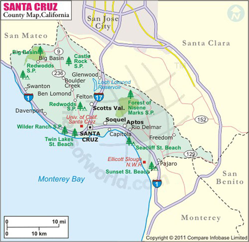
Below is the County Map of Santa Cruz in California showing the boundaries, roads, highways, towns and much more.

Map of Santa Cruz County in California
Santa Cruz County Map
Description:Santa Cruz County Map showing the County boundaries, County seat, major cities, highways, roads, rail network, airports and point of interest. Disclaimer
×

Disclaimer  :  All efforts have been made to make this image accurate. However MapSherpa, Inc, its directors and employees do not own any responsibility for the correctness or authenticity of the same.


The County of Santa Cruz is located on the Pacific coast of California. The county makes up the northern coast of the Monterey Bay in Northern California. The county seat and its largest city is Santa Cruz. Covering a total area of 607 square miles, it is the third smallest county in California. The county features rugged coast, mountainous terrain, and coastal lowlands.

Nicknamed “Surf City,” Santa Cruz is known for coastal redwood forests, alternative community lifestyles, over 29 miles of beaches, and year-round pleasant climate. The Santa Cruz Surfing Museum, the Santa Cruz Beach Boardwalk, Natural Bridges State Beach, Pogonip Open Space, and Santa Cruz Wharf are famous attractions in the city.


As shown in the map, Redwoods State Park, Wilder Ranch State Park, and Twin Lakes State Beach are popular getaways in the region. Watsonville, Live Oak, Scotts Valley, and Capitola are major cities in Santa Cruz County. State Route 1, SR 9, SR 17, and SR 35 are major transportation corridors in the county. Amtrak's Thruway Motorcoach service connects Santa Cruz with San Jose Diridon Train Station. International airports in San Jose and San Francisco are less than two hours away from Santa Cruz.

MOW.DT.01.09.17


Inside the page

Facts about Santa Cruz County

County NameSanta Cruz County
FoundedFeb 18, 1850
Area1,570 km2 (607 sq mi)
Land Area1,150 km2 (445 sq mi)
Water Area420 km2 (162 sq mi)
Population262,382 (2010)
Largest citySanta Cruz
County SeatSanta Cruz
Time zonePacific Standard Time (UTC-8) Summer (DST) Pacific Daylight Time (UTC-7)

Cities in Santa Cruz County


CityPopulation (2010)
  • Amesti
  • 3,478
  • Aptos
  • 6,220
  • Aptos Hills-Larkin Valley
  • 2,381
  • Ben Lomond
  • 6,234
  • Bonny Doon
  • 2,678
  • Boulder Creek
  • 4,923
  • Brookdale
  • 1,991
  • Capitola city
  • 9,918
  • Corralitos
  • 2,326
  • Davenport
  • 408
  • Day Valley
  • 3,409
  • Felton
  • 4,057
  • Freedom
  • 3,070
  • Interlaken
  • 7,321
  • La Selva Beach
  • 2,843
  • Live Oak
  • 17,158
  • Lompico
  • 1,137
  • Mount Hermon
  • 1,037
  • Pajaro Dunes
  • 144
  • Paradise Park
  • 389
  • Pasatiempo
  • 1,041
  • Pleasure Point
  • 5,846
  • Rio del Mar
  • 9,216
  • Scotts Valley city
  • 11,580
  • Seacliff
  • 3,267
  • Soquel
  • 9,644
  • Twin Lakes
  • 4,917
  • Watsonville city
  • 51,199
  • Zayante
  • 705


    Mountain Peaks in Santa Cruz County


    Mountain Peak/HillElevation [Meter]
    Atherton Peak490
    Bald Mountain399
    Bean Hill442
    Bear Creek Summit736
    Beehive670
    Ben Lomond Mountain800
    Bolcoff Hill26
    Buzzards Roast674
    Chalk Mountain492
    Eagle Dell Peak428
    Eagle Rock751
    La Corona137
    McAbee Mountain561
    Mount Bielawski984
    Mount Pajaro480
    Mount Roberta453
    Ocean View Summit515
    Pine Mountain670
    Sand Point541
    Santa Rosalia Mountain788
    Sugarloaf Mountain366
    Table Rock15

    Airports in Santa Cruz County


    Airport Name
    Alta Vista Heliport
    Bonny Doon Village Airport
    Dominican Santa Cruz Hospital Heliport
    Las Trancas Airport
    Monterey Bay Academy Airport
    Watsonville Community Hospital Heliport
    Watsonville Municipal Airport


    Golf Courses in Santa Cruz County


    Name of Golf CourseLatitudeLongitude
    Boulder Creek Golf & Country Club-Boulder Creek37.153905-122.161511
    Casserly Par 3 Golf Course-Watsonville36.976146-121.744481
    De Laveaga Golf Course-Santa Cruz36.9972-122.001574
    Pasatiempo Golf Club-Santa Cruz37.004344-122.026123
    Seascape Golf Club-Aptos36.967186-121.882764
    Spring Hills Golf Course-Watsonville36.978272-121.753209
    Valley Gardens Golf Course-Scotts Valley37.047478-122.032939


    Map of Cities in California

    Long Beach city MapOakland city MapAnaheim city Map
    Santa Ana city MapRiverside city MapStockton city Map
    Chula Vista city MapFremont city MapIrvine city Map
    San Bernardino city MapModesto city MapOxnard city Map
    Los Angeles city Map San Francisco city Map Sacramento city Map
    San Jose city Map Bakersfield city Map Fullerton city Map


    Last Updated Date: January 09th, 2017