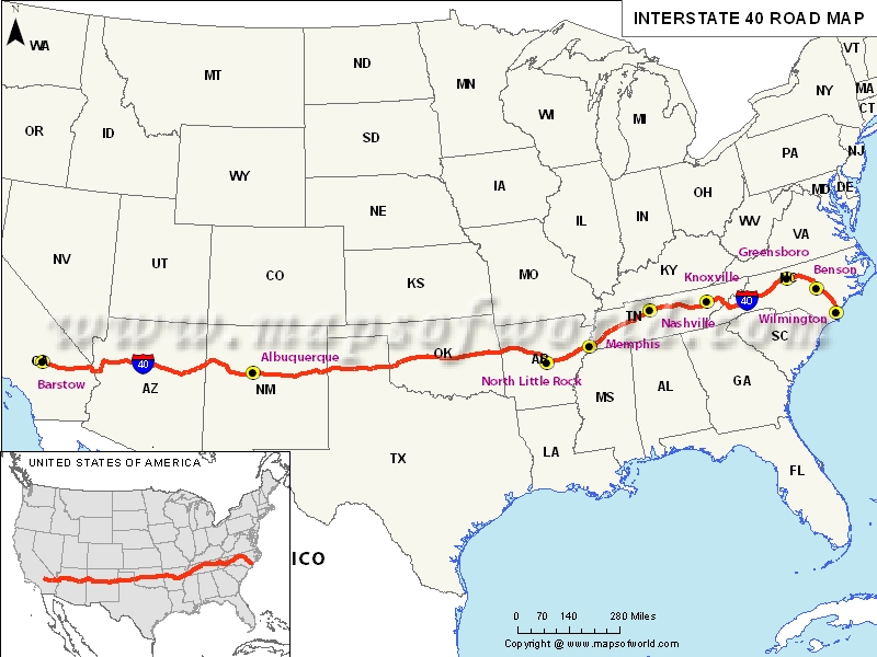
The US Interstate-40 Highway
According to the US interstate highway map, the interstate-40 is the third largest component in the interstate highway system. This major highway covers eight states along its cross-country expedition. The interstate extends from Barstow in California state and runs through Mojave Desert located in San Bernardino County. It goes through Arizona on the southwestern side of Kingman all the way to Wilmington in the North Carolina where its journey ends.
Commuters, who usually depend on sign boards to read distances ,are advised to be cautious around Barstow California since the sign indicating the distance to Wilmington in North Carolina is susceptible to theft, and hence, commuters can miss vital signs along the way.
States Covered
The highway usually transverse California, Arizona, New Mexico, Texas, Oklahoma, Arkansas, Tennessee and North Carolina states. Most of the regions along this major highway have sunny and partial cloudy weather patterns.
Travelers using I-40 can take a breather at various rest points located along this highway. Around North Carolina area, Warsaw, Burlington, and Benson are popular rest areas where commuters can relax. If you are looking to have a stopover around Tennessee, can relax in Dandridge, Ozone, Buffalo Valley and Monterey rest areas.
You will feel tempted to stop by various attractions along the Interstate-40 highway. From the Grand Canyon's thunderous red cliffs in the north of Williams Arizona state to marvelous boat rides in Lake Avastu City, where the original London Bridge is located, these destinations will keep you enthralled during the road trip.
Route of Interstate Highway No.40 |
|---|
| State | Entry Point | Exit Point | Length |
|---|
| California | Barstow, CA | Needles, CA | 154.623 mi (248.842 km) |
| Arizona | Topock, AZ | Holbrook, AZ | 359.11 mi (577.93 km) |
| New Mexico | Gallup, NM | Endee, NM | 373.510 mi (601.106 km) |
| Texas | New Mexico state line, TX | Oklahoma state line, TX | 177.139 mi (285.078 km) |
| Oklahoma | Erick, OK | Sallisaw, OK | 331 mi (533 km) |
| Arkansas | Fort Smith, AR | West Memphis, AR | 284.69 mi (458.16 km) |
| Tennessee | Memphis, TN | Newport, TN | 455.28 mi (732.70 km) |
| North Carolina | Tennessee state line, NC | Wilmington, NC | 423.55 mi (681.64 km) |
| Total Length | | | 2,555.10 mi (4,112.03 km) |


