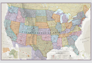
Counties are the administrative subdivision in the United States of America. The expression 'county' is applied in 48 out of the 50 States. Our
USA County Map shows the location of each
county in the US.
About our US County Map
The administration of the United States of America is divided into three levels; States, Counties, and Towns. Currently there are 3,142 counties in the US. San Bernardino County, California, is the largest county with an area of 20,057 square miles (51,950 sq. km), while Kalawao County, Hawaii, is the smallest with an area of 12 square miles (31 sq. km). States are divided into counties for administrative purposes.
Forty-eight out of the fifty states in the US use the term county. Alaska uses the term boroughs, and in the state of Louisiana they are called Parishes (In Louisiana, they take this seriously). Presently, the United States has 3,007 counties and 137 county equivalents for a total of 3,142 counties, and county equivalents.
Average Number of Counties in each state
The average number of counties in each state is 62. Yet, Delaware has only three counties, while Texas comprises of 254 counties. The term “county seat” is used for the administrative center, or the seat of the government.
County Population and Sizes (smallest and largest)
As per the 2015 statistics, Los Angeles County, California, is the most populous county, with a population of 10.17 million people. The least populous counties are the Kalawao County of Hawaii with only 89 people, and the Loving County in Texas, that is home to 82 people.
In terms of size, the smallest county is the Kalawao County in Hawaii. It covers an area of 13 square miles. The biggest county is the San Bernardino County in California. It covers an area of 20,105 square miles.
Some cities are counties
In some parts of the country, a city is also a county, and these areas exercise the powers and responsibilities of both categories of administration. For example, San Francisco, California is both the city of San Francisco, and the San Francisco County. Indianapolis, Indiana has this distinction as well.
Facts
- Most counties are governed by a county commission, that is made up of a board of administrators, county council, and often landowners. Larger counties often employ a county executive and staff.
- The tiniest county is the Independent City of Falls Church, Virginia. A tiny county equivalent with an area of 2 sq. mi (5.2 sq. km) only.
- By recent statistics, Loudoun County, a Virginia suburb of Washington, D.C., ranks as the highest-income county in the US.
- Sumter County, west of Orlando, Florida, houses the largest population of senior citizens. More than half (52.9%) the residents are 65 or older.
- Washington, D.C., holds the prestigious place of being the most educated county, as it houses the largest of the nation’s employers, the federal government.
- There are 40 city-counties in the US, including Denver, Colorado; Indianapolis, Indiana; Jacksonville, Florida; Louisville, Kentucky; Nashville, Tennessee; New Orleans, Louisiana (Remember it’s a Parish); Philadelphia, Pennsylvania; and San Francisco, California.
- The city-boroughs of Alaska are cities that rank among the geographically largest cities in the world, yet their population densities are far below those of most urban places.
- The other terms for the county seat are county courthouse, the parish seat (Louisiana), and the ‘borough seat’ (Alaska).
- Many counties are also divided further, into smaller political or governmental units. For example, some northeastern and midwestern states divided some counties into ‘townships.’ These units proffer governmental or public services to the people.
List showing states with number of Counties and Equivalents |
|---|
| State or District | Land Area (Sq Mi) | Land Area (Sq Km) | Number of Counties | Number of Equivalents* | Total Number# |
|---|
| Alabama | 50,645 | 131,171 | 67 | 0 | 67 |
| Alaska | 570,641 | 1,477,953 | 0 | 30 | 30 |
| Arizona | 113,594 | 294,207 | 15 | 0 | 15 |
| Arkansas | 52,035 | 134,771 | 75 | 0 | 75 |
| California | 155,779 | 403,466 | 58 | 0 | 58 |
| Colorado | 103,642 | 268,431 | 64 | 0 | 64 |
| Connecticut | 4,842 | 12,542 | 8 | 0 | 8 |
| Delaware | 1,949 | 5,047 | 3 | 0 | 3 |
| District of Columbia | 61 | 158 | 0 | 1 | 1 |
| Florida | 53,625 | 138,887 | 67 | 0 | 67 |
| Georgia | 57,513 | 148,959 | 159 | 0 | 159 |
| Hawaii | 6,423 | 16,635 | 5 | 0 | 5 |
| Idaho | 82,643 | 214,045 | 44 | 0 | 44 |
| Illinois | 55,519 | 143,793 | 102 | 0 | 102 |
| Indiana | 35,826 | 92,789 | 92 | 0 | 92 |
| Iowa | 55,857 | 144,669 | 99 | 0 | 99 |
| Kansas | 81,759 | 211,754 | 105 | 0 | 105 |
| Kentucky | 39,486 | 102,269 | 120 | 0 | 120 |
| Louisiana | 43,204 | 111,898 | 0 | 64 | 64 |
| Maine | 30,843 | 79,883 | 16 | 0 | 16 |
| Maryland | 9,707 | 25,142 | 23 | 1 | 24 |
| Massachusetts | 7,800 | 20,202 | 14 | 0 | 14 |
| Michigan | 56,539 | 146,435 | 83 | 0 | 83 |
| Minnesota | 79,627 | 206,232 | 87 | 0 | 87 |
| Mississippi | 46,923 | 121,531 | 82 | 0 | 82 |
| Missouri | 68,742 | 178,040 | 114 | 1 | 115 |
| Montana | 145,546 | 376,962 | 56 | 0 | 56 |
| Nebraska | 76,824 | 198,974 | 93 | 0 | 93 |
| Nevada | 109,781 | 284,332 | 16 | 1 | 17 |
| New Hampshire | 8,953 | 23,187 | 10 | 0 | 10 |
| New Jersey | 7,354 | 19,047 | 21 | 0 | 21 |
| New Mexico | 121,298 | 314,161 | 33 | 0 | 33 |
| New York | 47,126 | 122,057 | 62 | 0 | 62 |
| North Carolina | 48,618 | 125,920 | 100 | 0 | 100 |
| North Dakota | 69,001 | 178,711 | 53 | 0 | 53 |
| Ohio | 40,861 | 105,829 | 88 | 0 | 88 |
| Oklahoma | 68,595 | 177,660 | 77 | 0 | 77 |
| Oregon | 95,988 | 248,608 | 36 | 0 | 36 |
| Pennsylvania | 44,743 | 115,883 | 67 | 0 | 67 |
| Rhode Island | 1,034 | 2,678 | 5 | 0 | 5 |
| South Carolina | 30,061 | 77,857 | 46 | 0 | 46 |
| South Dakota | 75,811 | 196,350 | 66 | 0 | 66 |
| Tennessee | 41,235 | 106,798 | 95 | 0 | 95 |
| Texas | 261,232 | 676,587 | 254 | 0 | 254 |
| Utah | 82,170 | 212,818 | 29 | 0 | 29 |
| Vermont | 9,217 | 23,871 | 14 | 0 | 14 |
| Virginia | 39,490 | 102,279 | 95 | 38 | 133 |
| Washington | 66,456 | 172,119 | 39 | 0 | 39 |
| West Virginia | 24,038 | 62,259 | 55 | 0 | 55 |
| Wisconsin | 54,158 | 140,268 | 72 | 0 | 72 |
| Wyoming | 97,093 | 251,470 | 23 | 0 | 23 |
| Total | 3,531,905 | 9,147,592 | 3,007 | 136 | 3,142 |
*: County-Equivalent: A city or an area in a state with no county-level government
#: Total number of Counties and Equivalents in a state