US States Location Maps
- Alabama
- Alaska
- Arizona
- Arkankas
- Colorado
- California
- Connecticut
- Delaware
- Florida
- Georgia
- Hawaii
- Idaho
- Illinois
- Indiana
- Iowa
- Kansas
- Kentucky
- Louisiana
- Maine
- Maryland
- Massachusetts
- Michigan
- Minnesota
- Mississippi
- Missouri
- Montana
- Nebraska
- Nevada
- New Hampshire
- New Jersey
- New Mexico
- New York
- North Carolina
- North Dakota
- Ohio
- Oklahoma
- Oregon
- Pennsylvania
- Rhode Island
- South Carolina
- South Dakota
- Tennessee
- Texas
- Utah
- Vermont
- Virginia
- Washington
- West Virginia
- Wisconsin
- Wyoming
Search U.S. City Location
| Email This Link | Save |
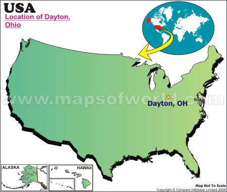
| Location: | Dayton, Ohio |
| Latitude: | 39.45N |
| Longitude: | 84.12W |
Disclaimer : All efforts have been made to make this image accurate. However MapSherpa, Inc, its directors and employees do not own any responsibility for the correctness or authenticity of the same.
| Facts About Dayton |
| City Name | Dayton |
|---|---|
| Continent | North America |
| Country | United State (USA) |
| State | Ohio |
| Capital and largest city | NA |
| Area | 56.50 sq mi (146.33 km2) |
| Population | 141,527 (2010) |
| Lat Long | 39°45′34″N 84°11′30″W |
| Official Language | De jure: None, De facto: English |
| Calling Code | 937 |
| Time Zone | EST (UTC-5) Summer (DST) EDT (UTC-4) |
| Airport | Dayton International Airport |
| Neighbour State | Michigan, Pennsylvania, Kentucky, Indiana, West Virginia |
| Internet TLD | |
| Currency | United State Dollar (USD) |
| Location Map of Ohio Cities |


