Yemen Latitude and Longitude Map
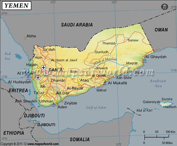
Yemen's latitude and longitude is 15° 0' N and 48° 0 ' E . Below is the map of Yemen showing major towns, roads, airports with latitudes and longitudes plotted on it.
Search For Latitude & Longitude Map
Or
Latitude
Longitude
Or
Area
* Put South & West values with minus ( - ) sign.
|
| Description: Find Yemen latitude and longitude map showing comprehensive details including cities, roads, towns, airports and much more. | Disclaimer |
The latitude and longitude of Yemen encloses an area which is mostly a desert. It also consists of a narrowly shaped coastal plain surrounded by rugged mountains. The climate of Yemen is a mix of hot, humid and temperate. The Western part experiences the effect of the seasonal monsoon. Towards the inner eastern region of Yemen, the climate gets unbearably hot. During summer, the temperature can go as high as up to 54° C and the winters are comparably cooler with the presence of frost in some parts. The average yearly temperature of the capital city of Sanaa is 18°C. Yemen also undergoes natural hazards in the form of dust and sandstorms.
| Locations | Latitude | Longitude |
| Abd al Kuri | 12°05'N | 52°20'E |
| Aden / Al'Adan | 12°45'N | 45°00'E |
| Ahwar | 13°30'N | 46°40'E |
| Al 'Adan, | 12°45'N | 45°00'E |
| Al Hudaydah | 14°50'N | 43°00'E |
| Al Luhayyah | 15°45'N | 42°40'E |
| Al Mukalla | 14°33'N | 49°02'E |
| Al Mukha | 13°18'N | 43°15'E |
| Barim | 12°39'N | 43°25'E |
| Fartak, Ra's | 15°38'N | 52°15'E |
| Hadhramaut / Hadramawt | 15°30'N | 49°30'E |
| Hadiboh | 12°39'N | 54°02'E |
| Hadramawt | 15°30'N | 49°30'E |
| Hanish | 13°45'N | 42°46'E |
| Hodeida / Al Hudaydah | 14°50'N | 43°00'E |
| Kamaran | 15°21'N | 42°35'E |
| Khamir | 16°02'N | 44°00'E |
| Manar, Jabal | 14°02'N | 44°17'E |
| Nisab | 14°25'N | 46°29'E |
| San | 15°27'N | 44°12'E |
| Gayhut | 15°12'N | 51°10'E |


