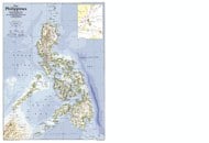
Philippines Latitude and Longitude Map
Philippines's latitude and longitude is 13° 00 N and 122° 00 E. Below is the map of Philippines showing major towns, roads, airports with latitudes and longitudes plotted on it.

-
Philippines Map
$19.99
-
Philippines Map
$18.45
| Description : Find Philippines latitude and longitude map showing comprehensive details including cities, roads, towns, airports and much more. | Disclaimer |
×
Disclaimer : All efforts have been made to make this image accurate. However MapSherpa, Inc, its directors and employees do not own any responsibility for the correctness or authenticity of the same.