- Yemen Cities - Al Ghaydah, Hajjah, Sanaa
- Neighboring Countries - Oman, Saudi Arabia, Somalia, Djibouti, Eritrea
- Continent And Regions - Asia Map
- Other Yemen Maps - Yemen Map, Where is Yemen, Yemen Blank Map, Yemen Road Map, Yemen River Map, Yemen Flag
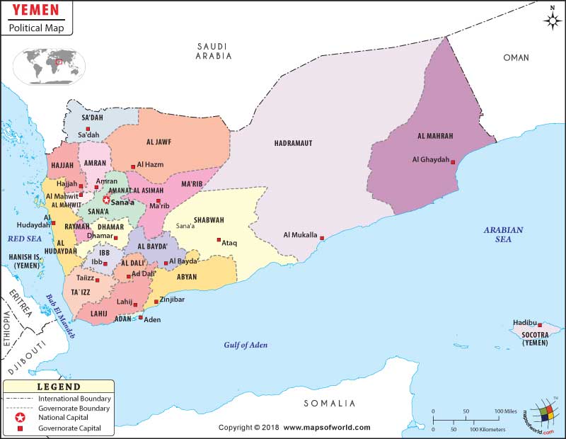
The country of Yemen has bicameral legislature. The population of the country as per the estimate of July 2007 is 22,230,531. The residents of the country are known as Yemenis. Arabic is spoken by the Yemenis. The country is officially known as Republic of Yemen. In the political map of Yemen, major cities, national capital, boundaries and Sana’a s are marked.
Yemen Features
Yemen is an Asian country, which is located in the Arabian Peninsula. Yemen, a southwestern Asian country is the only country, which is republic in Arabia Peninsula. The country happens to be one of the oldest hubs of global civilization. The geographic coordinates of Yemen are 15° North latitude and 48° East longitude. The total area covered by the country is 527,970 square kilometers. The scale of the map is provided.
Yemen Sana’a Capitals
Yemen has been divided into 19 governorates, which have been marked in the political map of Yemen by different colors. The capitals of the governorates of Yemen have been highlighted in the political Yemen map by white squares. The governorates of the country are ‘Adan Abyan, Al Bayda’, Ad Dali’, Al Jawf, Al Hudaydah, Al Mahwit, Al Mahrah, Dhamar, ‘Amran, Hajjah, Hadramawt, Lahij, Ibb, Sa’dah, Ma’rib, Shabwah, San’a’ and Ta’izz.
Some of the indicated capitals of the governorates in the map of Yemen are:
- Aden
- Lahij
- Ta’izz
- Ad Dali
- Al Bayda
- Ataq
- Ibb
- Sa’dah
- Al Ghaydah
- Al Mukalla
Yemen Boundaries
The bordering countries and water bodies of Yemen are marked in the printable Yemen Map. The international boundaries are indicated by black lines. The neighboring countries of Yemen are:
- Somalia
- Ethiopia
- Djibouti
- Eritrea
- Kingdom of Saudi Arabia
- Sultanate of Oman
The water bodies surrounding Yemen are:
- Gulf of Aden to the south
- Bab El Mandeb to southwest
- Red Sea in the west
- Arabian Sea in the south
Yemen Capital
The capital of Yemen is Sanaa. The capital city is indicted in the map of Yemen by a red square. The geographic coordinates of Sanaa are 15° 21′ 17″ North latitude and 44° 12′ 24″ East longitude. The capital city is 7394 feet above sea level. The city is served by Sanaa International airport. Some of the cities that are located in close proximity to Sanaa are Qaryat ‘Asr al Asfal, Sa’wan, Bayt Majraz, ‘Attan, Bayt Mi’yad and Bayt Hadir.
| Sana’a | Population | Area(km.²) | Area(mi.²) | Capital |
|---|---|---|---|---|
| Abyan | 433,819 | 16,450 | 6,350 | Zinjibar |
| `Adan | 589,419 | 760 | 290 | Aden |
| Al Bayda’ | 577,369 | 9,270 | 3,580 | Al Bayda |
| Al Dali’ | 470,564 | 4,000 | 1,540 | Al Dali’ |
| Al Hudaydah | 2,157,552 | 13,250 | 5,120 | Al Hudaydah |
| Al Jawf | 443,797 | 39,500 | 15,250 | Al Hazm Al Jawf |
| Al Mahrah | 88,594 | 67,310 | 25,990 | Al Ghaydah |
| Al Mahwit | 494,557 | 2,330 | 900 | Al Mahwit |
| Amran | 877,786 | 7,900 | 3,050 | Amran |
| Dhamar | 1,330,108 | 7,590 | 2,930 | Dhamar |
| Hadramawt | 1,028,556 | 167,280 | 64,590 | Al Mukalla |
| Hajjah | 1,479,568 | 8,300 | 3,200 | Hajjah |
| Ibb | 2,131,861 | 5,350 | 2,070 | Ibb |
| Lahij | 722,692 | 12,650 | 4,880 | Lahij |
| Ma’rib | 238,522 | 17,450 | 6,740 | Ma’rib |
| Raymah | 394,448 | Jabin | ||
| Sa`dah | 695,033 | 12,370 | 4,780 | Sa`dah |
| San`a’ | 919,215 | 13,850 | 5,350 | San`a’ |
| San`a’ [City] | 1,747,834 | 380 | 150 | San`a’ |
| Shabwah | 470,635 | 39,000 | 15,060 | `Ataq |
| Ta`izz | 2,393,425 | 10,010 | 3,860 | Ta`izz |
| 21 divisions | 19,684,603 | 455,000 | 175,680 |

 Facts about Yemen