logo


Afghanistan Latitude and Longitude Map

Afghanistan's latitude and longitude is 33° 00' N and 65° 00' E . Below is the map of Afghanistan showing major towns, roads, airports with latitudes and longitudes plotted on it.
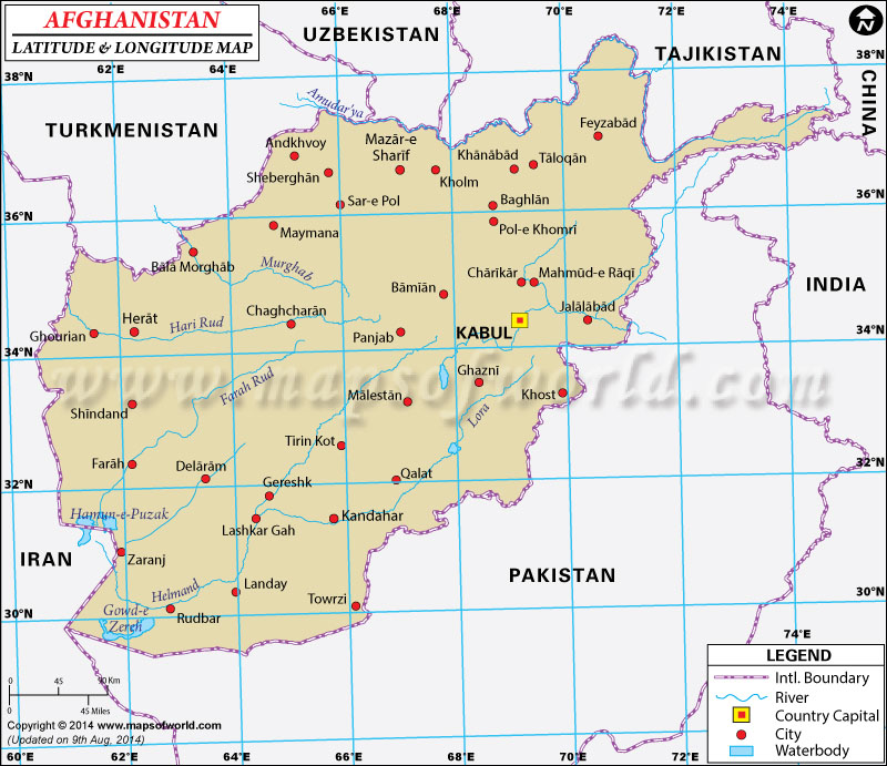
Afghanistan Latitude and Longitude Map Uzbekistan Lat Long Map Tajikistan Lat Long Map China Lat Long Map India Lat Long Map Pakistan Lat Long Map Iran Lat Long Map Turkmenistan Lat Long Map
Description : Find Afghanistan latitude and longitude map showing comprehensive details including cities, roads, towns, airports and much more. Disclaimer
×

Disclaimer  :  All efforts have been made to make this image accurate. However MapSherpa, Inc, its directors and employees do not own any responsibility for the correctness or authenticity of the same.


Search For Latitude & Longitude Map

By Country

Or

Latitude

Longitude

Or

Area

* Put South & West values with minus ( - ) sign.

The latitude and longitude of Afghanistan is 33º 00' N and 65º 00' E respectively. It is located in Southern Asia and lies on the northwestern part of Pakistan.
The total area is slightly smaller than that of Texas. There are 34 provinces in Afghanistan and it lies in the northern hemisphere. Kabul, the capital, lies in 34º 31' N latitude and 69º 12' E longitude. Afghanistan is 9.5 hours ahead of the Standard Time.

The climate of Afghanistan mostly ranges from arid to semi-arid type and it has cold winters and hot summers. There is an acute shortage of natural fresh water resources in Afghanistan. The area is landlocked since the Hindu Kush mountains run northeast to southwest of the region and divide it into two parts. As a result, there are no coastlines or maritime influences on the weather. Disastrous earthquakes, floods and droughts are common in the region.


Latitude and Longitude of Afganistan

LocationLatitudeLongitude
Ali Khel33 57'N69 43'E
Arghandab31°30'N64°15'E
Ashkarkot33°03'N67°58'E
Baba, Koh-i34°30'N67°00'E
Badakhshan36°30'N71°00'E
Badalzai29°50'N65°35'E
Badghis35°00'N63°00'E
Baghlan32°12'N68°46'E
Baghlan36°00'N68°30'E
Balabagh34°25'N70°12'E
Bamian35°00'N67°00'E
Basawa34°15'N70°50'E
Chagai Hills29°30'N64°00'E
Chaghcharan34°31'N65°15'E
Chah Gay Hills29°30'N64°00'E
Chahar Burjak30°15'N62°00'E
Chakhansur31°10'N62°00'E
Charikar35°00'N69°10'E
Dand31°28'N65°32'E
Diwal Kol34°23'N67°52'E
Dughi Kala32°20'N62°50'E
Farah32°20'N62°07'E
Farah32°25'N62°10'E
Faryab36°00'N65°00'E
Gardez33°37'N69°09'E
Gereshk31°47'N64°35'E
Ghazni33°30'N68°28'E
Ghazni32°10'N68°20'E
Ghizao33°20'N65°44'E
Ghowr34°00'N64°20'E
Ghurian34°17'N61°25'E
Haidar Khel33°58'N68°38'E
Helmand31°20'N64°00'E
Helmand31°12'N61°34'E
Heart34°20'N62°07'E
Heart35°00'N62°00'E
Jalalabad34°30'N70°29'E
Kabul34°28'N69°11'E
Kabul34°30'N69°00'E
Kadanai31°22'N65°45'E
Kaga34°14'N70°10'E
Kandahar31°32'N65°43'E
Kapisa35°00'N69°20'E
Kashk-e-Kohneh34°55'N62°30'E
 
LocationLatitudeLongitude
Khojak Pass30°51'N66°34'E
Khowst33°22'N69°58'E
Khowst33°20'N70°00'E
Khugiani31°37'N65°04'E
Khush32°55'N62°10'E
Khyber Pass34°10'N71°08'E
Koh-i-Khurd33°30'N65°59'E
Konarha34°30'N71°03'E
Kulungar34°00'N69°02'E
Lash-e Joveyn31°45'N61°30'E
Lora31°35'N66°32 'E
Lowgar34°0'N69°0'E
Maidan Khula33°36'N36°50'E
Margow Dasht-e30°40'N62°30'E
Maruf31°30'N67°06'E
Matun33°22'N69°58'E
Meymaneh35°53'N64°38'E
Moqor32°50'N67°42'E
Mukur32°50'N67°42'E
MAfghanistan Qal'eh32°20'N64°50'E
Nangarhar34°20'N70°0'E
Narin36°05'N69°0'E
Nau Qala34°05'N68°05'E
Nawar, Dasht-I33°52'N68°0'E
Nuristan35°20'N71°0'E
Oruzgan33°30'N66°0'E
Owbeh34°28'N63°10'E
Paktia33°30'N69°15'E
Paktika32°30'N69°0'E
Panjwai31°26'N65°27'E
Parvan35°0'N69°0'E
Qala-I-Jadid31°01'N66°25'E
Qala yangi 34°20'N66°30'E
Qandahar 31°32'N65°43'E
Qandahar 31°0'N65°0'E
Safid Kuh 34°45'N63°0'E
Sang-I-Masha33°8'N67°27'E
Sangar32°56'N65°30'E
Sangar Sarai34°27'N70°35'E
Sar-e Pol36°20'N65°50'E
Spin Buldak31°1'N66°25'E
Vardak34°0'N68°0'E
Zabol32°0'N67°0'E

Last Updated on: November 6th, 2017