US States Location Maps
- Alabama
- Alaska
- Arizona
- Arkankas
- Colorado
- California
- Connecticut
- Delaware
- Florida
- Georgia
- Hawaii
- Idaho
- Illinois
- Indiana
- Iowa
- Kansas
- Kentucky
- Louisiana
- Maine
- Maryland
- Massachusetts
- Michigan
- Minnesota
- Mississippi
- Missouri
- Montana
- Nebraska
- Nevada
- New Hampshire
- New Jersey
- New Mexico
- New York
- North Carolina
- North Dakota
- Ohio
- Oklahoma
- Oregon
- Pennsylvania
- Rhode Island
- South Carolina
- South Dakota
- Tennessee
- Texas
- Utah
- Vermont
- Virginia
- Washington
- West Virginia
- Wisconsin
- Wyoming
Search U.S. City Location
| Email This Link | Save |
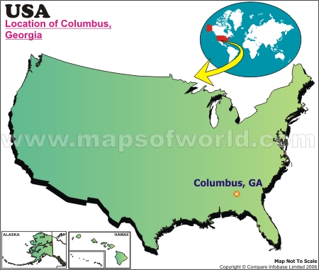
| Location: | Columbus, Ga. |
| Latitude: | 32.28N |
| Longitude: | 84.59W |
Disclaimer : All efforts have been made to make this image accurate. However MapSherpa, Inc, its directors and employees do not own any responsibility for the correctness or authenticity of the same.
| Facts About Columbus |
| City Name | Columbus |
| Continent | North America |
| Country | United State |
| State | Georgia |
| County | Muscogee |
| Capital and largest city | NA |
| Area | 220.8 sq mi (572 km2) |
| Population | 189,885 (2010) * |
| Lat Long | 32°29′32″N 84°56′25″W |
| Official Language | English, Spoken languages English, Spanish (7.42%) |
| Area code(s) | 706, 762 |
| Time Zone | CST (UTC−6) Summer (DST) CDT (UTC−5) |
| Nearest Airport | Columbus Metropolitan Airport |
| Currency | United States dollar ($) (USD) |
| Website | http://www.columbusga.org/ |
Source: http://census.gov/ / http://www.columbusga.org/
|
Last Updated on: December 28, 2016


