Africa Lat Long Maps
- South Africa Lat Long Map
- Egypt Lat Long Map
- Nigeria Lat Long Map
- Kenya Lat Long Map
- Morocco Lat Long Map
- Libya Lat Long Map
- Madagascar Lat Long Map
- Tanzania Lat Long Map
- Ethiopia Lat Long Map
- Sudan Lat Long Map
- Zambia Lat Long Map
- Zimbabwe Lat Long Map
- Uganda Lat Long Map
- Ghana Lat Long Map
- Tunisia Lat Long Map
- Mauritius Lat Long Map
- Somalia Lat Long Map
- Botswana Lat Long Map
- Mali Lat Long Map
- Algeria Lat Long Map
- Mozambique Lat Long Map
- Namibia Lat Long Map
- Congo Lat Long Map
- Angola Lat Long Map
- Gabon Lat Long Map
- Seychelles Lat Long Map
- Chad Lat Long Map
- Cameroon Lat Long Map
- Liberia Lat Long Map
- Senegal Lat Long Map
- Cape Verde Lat Long Map
- Rwanda Lat Long Map
- Malawi Lat Long Map
- Mauritania Lat Long Map
- Gambia Lat Long Map
- Togo Lat Long Map
- Burkina Lat Long Map
- Niger Lat Long Map
- Djibouti Lat Long Map
- Central African Republic Lat Long Map
- Cote D' Ivoire Lat Long Map
- eSwatini (Swaziland) Lat Long Map
- Equatorial Guinea Lat Long Map
- Benin Lat Long Map
- Burundi Lat Long Map
- Lesotho Lat Long Map
- Guinea Lat Long Map
- Guinea Bissau Lat Long Map
- Eritrea Lat Long Map
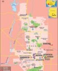
Tunisia Latitude and Longitude Map
Tunisia's latitude and longitude is 34° 00'N and 9° 00'E . Below is the map of Tunisia showing major towns, roads, airports with latitudes and longitudes plotted on it.
Search For Latitude & Longitude Map
Or
Latitude
Longitude
Or
Area
* Put South & West values with minus ( - ) sign.

|

| Description: Find Tunisia latitude and longitude map showing comprehensive details including cities, roads, towns, airports and much more. | Disclaimer |
The Tunisian Republic is located at the geographic coordinates of 34°00'N latitude and 9°00'E longitude . Known in Arabic as Al-Jumhuriyyah at-Tunisiyyah, Tunisia is located near the Mediterranean Ocean in North Africa. The Capital of Tunisia is the city of Tunis with the geographic location of 36°50'N latitude and 10°9'E longitude . Tunis is Arabic for both the country and the capital city. The word has originated from the Berber word which means Spending the Night.
The extended latitude and longitude of Tunisia span across an area of 163,610 sq km, making it the 92 nd largest country in terms of land area. The population of Tunisia is estimated to be 10,102,000. The ethnic majority are Arabs, followed by a few Europeans and Jews.
The geographical location of Tunisia and the areas covered by the latitude and longitude influence the climate and terrain of the land. The climate is usually temperate through the year. The climate in the north mountainous regions is cold and wet. While the semi arid plains in the south have dry summers. The southern regions gradually give over to the Sahara Desert. The tallest peak in Tunisia is the Jebel- ech-Chambi, which is 1,544 m high.
| Locations | Latitude | Longitude |
|---|---|---|
| Beja | 36°43'N | 09°12'E |
| Binzert / Bizerte | 37°15'N | 09°50'E |
| Bizerte | 37°15'N | 09°50'E |
| Bon, C. | 37°01'N | 11°02'E |
| Carthage | 36°50'N | 10°21'E |
| Dehibat | 32°00'N | 10°47'E |
| Djerba. I.de | 33°50'N | 10°48'E |
| Djerid, Chott | 33°42'N | 08°30'E |
| Gabes | 33°53'N | 10°02'E |
| Gabes, G. de | 34°00'N | 10°30'E |
| Gafsa | 34°24'N | 08°43'E |
| Jerid, Chott el / Djerid, Chott | 33°42'N | 08°30'E |
| Kairouan | 35°45'N | 10°05'E |
| Mahdia | 35°28'N | 11°0'E |
| Nabeul | 36°60'N | 10°44'E |
| Tozeur | 33°56'N | 8°8'E |
| Tunis | 36°50'N | 10°11'E |


"By clicking OK or by using this Website, you consent to the use of cookies. Your personal data will be governed by Mapsofworld Privacy Policy and Terms."
Get customize mapping solution including
For further info please get in touch with us at
 [email protected]

Copyright © 2024 mapsofworld.com. All Rights Reserved