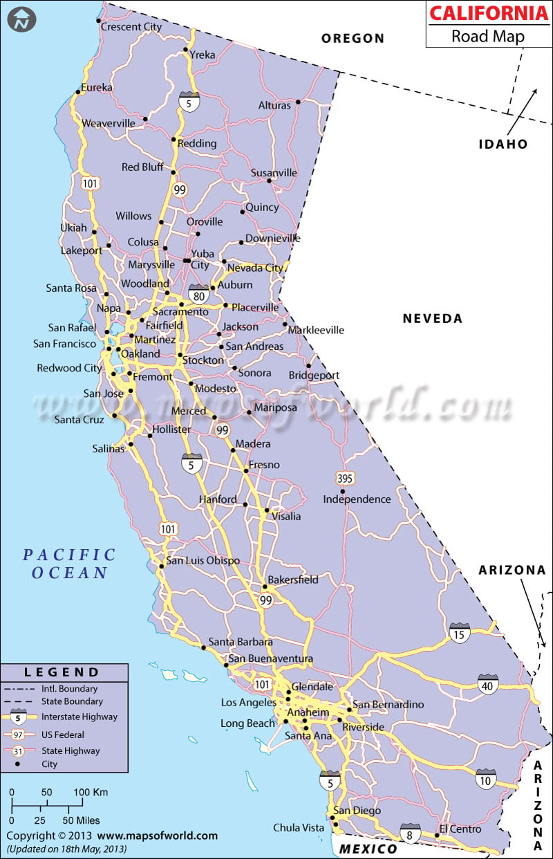
California Road Map is a comprehensive guide to the highways, roads, and freeways of California. It displays the major roads that run through cities and towns, as well as smaller roads that lead to scenic locations and attractions. This map is ideal for motorists and travelers, providing a clear and easy-to-use reference for navigation and trip planning. It includes information on road conditions, speed limits, rest areas, and other essential details for a smooth and safe driving experience. With the California Road Map, you can plan your route, estimate your travel time, and discover the best routes to your destination. Whether you’re traveling within the state or crossing into neighboring states, this map is an indispensable resource for any road trip.
California Roads
The huge territory of CA is linked by a huge network of expressways, freeways, and highways. The state is famous for its car culture and traffic congestion is a regular feature in most of the major cities. The California Department of Transportation (Caltrans) oversees the public transportation network in the state. This detailed California road map lets you find national highways, major roads, state capital (Sacramento), major towns, and small towns.
Highways in California
The Golden Gate Bridge, a famous landmark in San Francisco, is also known as U.S. Route 101. It is the longest highway in the state and the length is 808.111 miles or 1,300.529 km. It connects Los Angeles, CA with Olympia, Washington. The route forms a portion of the California Freeway and Expressway System. Other than this, the following national highways are there:
- U.S. Route 6 (Also known as Grand Army of the Republic Highway). The length is 3,205 miles (5,158 km) and connects Bishop, CA with Provincetown, Massachusetts.
- U.S. Route 50 – The length is 3,008 miles or 4,841 km. Connects Sacramento, CA with Ocean City, Maryland.
- U.S. Route 95 – The length is 1,574 miles or 2,533 km. Joins San Luiz, Arizona with Eastport, Idaho
- U.S. Route 97 – The length is 663 miles (1,067 km). Joins Weed, CA with the Canadian Border
- U.S. Route 199 – The length is 80.05 miles (128.83 km). Joins Del Norte, CA with Josephone, Oregon
- U.S. Route 395 – The length is 1,305 miles (2,100 km). Joins Hesperia, CA with Laurier, Washington close to US-Canada Boundary.
Interstate Highways in California
Given below are the interstate highways in the state and the states they connect California with:
- Interstate 5 – The length is 1,381.29 miles or 2,222.97 km (connects the capital cities of Washington, Oregon, and California)
- Interstate 8 – The length is 348.25 miles or 560.45 km (connects San Diego, CA with Casa Grande, Arizona)
- Interstate 10 – The length is 2,460.34 miles or 3,959.53 km (connects Santa Monica, CA with Jacksonville, Florida)
- Interstate 15 – The length is 1,433.52 miles (2,307.03 km) (connects San Diego, CA with Butte, Montana)
- Interstate 40 – The length is 2,555.10 miles or 4,112.03 km (connects Barstow, CA with Wilmington, North Carolina)
- Interstate 80 – The length of this interstate highway is 2,899.54 miles or 4,666.36 km (connects San Francisco, CA with Teaneck, New Jersey)
- Interstate 605 – The length is 27.40 miles (44.10 km). It connects Seal Beach with Huntingdon Drive in Irwindale, CA.
The northern and southern parts of the State of California are connected by Interstate 5 and Interstate 15. The eastern end of the state is joined to the western part of CA by Interstate roadways of 8, 10, 40 and 80. California has a total length of 8,327 miles of roadways that comprise national highways, freeways, and expressways. As our maps show, roads of California connect all the important cities of the state. The Department of Transportation of CA builds new roads and deals with the upkeep of old roads. The California Road Map clearly points out the important cities that are connected by the state and national highways of the state.
 Wall Maps