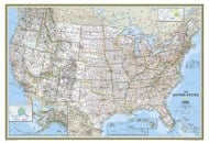
About the USA Map with Capitals
The United States, which is a federation of 50 states and a federal district, Washington D.C., is divided into Northeastern, Midwestern, Southern, and Western.
The East Coast of the USA, also known as the Atlantic Coast, has 14 states with coastlines on the Atlantic Ocean. Maine, New York, Rhode Island, Massachusetts, Maryland, Delaware, New Hampshire, Virginia, North Carolina, Connecticut, South Carolina, Georgia, New Jersey, and Florida are the states on the East Coast. Interestingly, the 13 original colonies of Great Britain in North America were all located along the East Coast.
Check
East Cost Map.
Some of these states also fall in the Southern USA. Popularly known as American South, the states in these regions have several cultural influences. Tennessee is the birthplace of jazz and blues music, and some of the best American writers have come from the South. The states in the Southern USA have earned a reputation as the major hub for tobacco, sugar, and cotton farming.
The Western US is the largest region of the country, as it spans more than half the area of the contiguous US. Home to the Rocky Mountains, Sierra Nevada Mojave Desert, and the Great Plains, it is the most geographically diverse region in America. It was inhabited after the Lewis and Clark expedition in the early 19th century. California, New Mexico, and Arizona have strong Mexican and Spanish cultural influences.
The Midwestern United States (or simply the Midwest) comprises seven states: Illinois, Indiana, Iowa, Michigan, Minnesota, Ohio, and Wisconsin. Known as the “Windy City,” Chicago is the largest city in the region. Indianapolis, Columbus, Detroit, and Milwaukee are other major cities. Known for its French heritage, Sault Ste. Marie, in Michigan, was the first European settlement in the region.
Here is the
Midwestern Map of USA
Popular US States
- California: The sun-soaked California on the Pacific Coast is home to important cities such as Los Angeles, San Francisco, and San Diego. The Golden Gate Bridge and Yosemite National Park are iconic symbols of the state. Check Out California Map
- Florida: From world-famous theme parks in Orlando to recreational dwellings in Key West, Florida is a popular tourist spot. This city known for its tropical weather has a number of Art-Deco buildings and ever-so tempting happening nightclubs in downtown Miami. Check out this Map of Florida State
- New York: From the Catskills mountains to the Central Park in Manhattan, New York state has unparalleled natural beauty. It is also home to the Niagara Falls, the Finger Lakes, Leetchworth State Park, and Adirondack Park. Click here for New York City Map
- Texas: There's so much to explore in Houston, Dallas, Austin, El Paso and San Antonio. From deer hunting in Hill Country to exploring Padre Island and trying Tex-Mex cuisine to watching the sunset in the Palo Duro Canyon, Texas offers endless delights. Get The Maps of Texas
- Hawaii: Considered a tropical paradise, Hawaii is a lovely vacation destination known for its exotic beauty. When in Hawaii, one must keep an eye out for spectacular waterfalls, volcanoes, sea cliffs, beaches and more.
Take a look at these
50 beautiful infographics of each state in the USA.
USA Flags
The flag of the United States, known as Old Glory, consists of thirteen horizontal red and white stripes and fifty white stars in a blue rectangle in the top left corner. The current American flag design was adopted on July 4, 1960. For flags of all states of the USA, check the
Flags of the 50 States.
Tourist Attractions
Some top attractions in the US:
- Mount Rushmore: Located in South Dakota, is a memorial that depicts the faces of four popular US presidents: George Washington, Abraham Lincoln, Thomas Jefferson, and Theodore Roosevelt.
- Venice Beach: This beach is situated in Los Angeles and is a nice place for people watching.
- Kennedy Space Center: Here, you can see the rockets that took the first men to the moon. The Kennedy Space Center is located in Florida.
- You can also check Space Explorations Around the World.
- French Quarters: Explore the French influence in New Orleans by visiting the French Quarters.
- Walt Disney World: Catch the fun at Walt Disney World, an amusement park located in Orlando, Florida.
- Visit this amazing Walt Disney World (Florida) Infographic.
- Denali National Park: If in central Alaska, do make a point to visit Denali National Park where you may see spectacular wildlife, such as caribou, wolves, moose, and grizzly bears, to name a few.
Apart from these, there are many other attractions that deserve a visit, such as Florida Keys, Niagara Falls, Yellowstone, Manhattan Grand Canyon, etc.
Facts about USA States
- Alaska, the largest state in the US, has about 3 million lakes and more than 100,000 glaciers.
- Delaware is known as the 1st State.
- Famous for the Everglades, the state of Florida is larger than England.
- In 1869, Wyoming was the first state to give women the right to vote.
- The One World Trade Center (or Freedom Tower) in New York City is the tallest building in the US.
- State is the only state named after a president.
- California grows more food than any other US State.
- Maryland has the oldest airport in America.
| List of 50 States with Nicknames, Capital and Largest Cities |
|---|
| State | Capital | Largest city | Nickname | Became a state |
|---|
| Alabama | Montgomery | Birmingham | Heart of Dixie | December 14, 1819 |
| Alaska | Juneau | Anchorage | The Last Frontier | January 3, 1959 |
| Arizona | Phoenix | Phoenix | Grand Canyon State | February 14, 1912 |
| Arkansas | Little Rock | Little Rock | The Natural State | June 15, 1836 |
| California | Sacramento | Los Angeles | The Golden State | September 9, 1850 |
| Colorado | Denver | Denver | Centennial State | August 1, 1876 |
| Connecticut | Hartford | Bridgeport | Constitution State | January 9, 1788 |
| Delaware | Dover | Wilmington | The First State | December 7, 1787 |
| Florida | Tallahassee | Jacksonville | Sunshine State | March 3, 1845 |
| Georgia | Atlanta | Atlanta | Peach State | February 12, 1733 |
| Hawaii | Honolulu | Honolulu | Aloha State | August 21, 1959 |
| Idaho | Boise | Boise | Gem State | July 3, 1890 |
| Illinois | Springfield | Chicago | Prairie State | December 3, 1818 |
| Indiana | Indianapolis | Indianapolis | Hoosier State | December 11, 1816 |
| Iowa | Des Moines | Des Moines | Hawkeye State | December 28, 1846 |
| Kansas | Topeka | Wichita | Sunflower State | January 29, 1861 |
| Kentucky | Frankfort | Louisville | Bluegrass State | June 1, 1792 |
| Louisiana | Baton Rouge | New Orleans | Pelican State | April 30, 1812 |
| Maine | Augusta | Portland | Pine Tree State | March 15, 1820 |
| Maryland | Annapolis | Baltimore | Old Line State | April 28, 1788 |
| Massachusetts | Boston | Boston | The Bay State | February 6, 1788 |
| Michigan | Lansing | Detroit | The Great Lakes State | January 26, 1837 |
| Minnesota | St. Paul | Minneapolis | North Star State | May 11, 1858 |
| Mississippi | Jackson | Jackson | Magnolia State | December 10, 1817 |
| Missouri | Jefferson City | Kansas City | Show-Me State | August 10, 1821 |
| Montana | Helena | Billings | Treasure State | November 8, 1889 |
| Nebraska | Lincoln | Omaha | Cornhusker State | March 1, 1867 |
| Nevada | Carson City | Las Vegas | Silver State | October 31, 1864 |
| New Hampshire | Concord | Manchester | Granite State | June 21, 1788 |
| New Jersey | Trenton | Newark | Garden State | December 18, 1787 |
| New Mexico | Santa Fe | Albuquerque | Land of Enchantment | January 6, 1912 |
| New York | Albany | New York City | The Empire State | July 26, 1788 |
| North Carolina | Raleigh | Charlotte | First in Flight State | November 21, 1789 |
| North Dakota | Bismarck | Fargo | Peace Garden State | November 2, 1889 |
| Ohio | Columbus | Columbus | Buckeye State | March 1, 1803 |
| Oklahoma | Oklahoma City | Oklahoma City | Sooner State | November 16, 1907 |
| Oregon | Salem | Portland | Beaver State | February 14, 1859 |
| Pennsylvania | Harrisburg | Philadelphia | Keystone State | December 12, 1787 |
| Rhode Island | Providence | Providence | Ocean State | May 29, 1790 |
| South Carolina | Columbia | Columbia | Palmetto State | July 20, 1904 |
| South Dakota | Pierre | Sioux Falls | Mount Rushmore State | November 2, 1889 |
| Tennessee | Nashville | Memphis | Volunteer State | June 1, 1796 |
| Texas | Austin | Houston | Lone Star State | December 29, 1845 |
| Utah | Salt Lake City | Salt Lake City | Beehive State | January 4, 1896 |
| Vermont | Montpelier | Burlington | Green Mountain State | March 4, 1791 |
| Virginia | Richmond | Virginia Beach | The Old Dominion | June 25, 1788 |
| Washington | Olympia | Seattle | Evergreen State | November 11, 1889 |
| West Virginia | Charleston | Charleston | Mountain State | June 20, 1863 |
| Wisconsin | Madison | Milwaukee | Badger State | May 29, 1848 |
| Wyoming | Cheyenne | Cheyenne | Equality State | July 10, 1890 |