
|
Nicaragua Map
- San Cristobal Volcano Eruption in Nicaragua
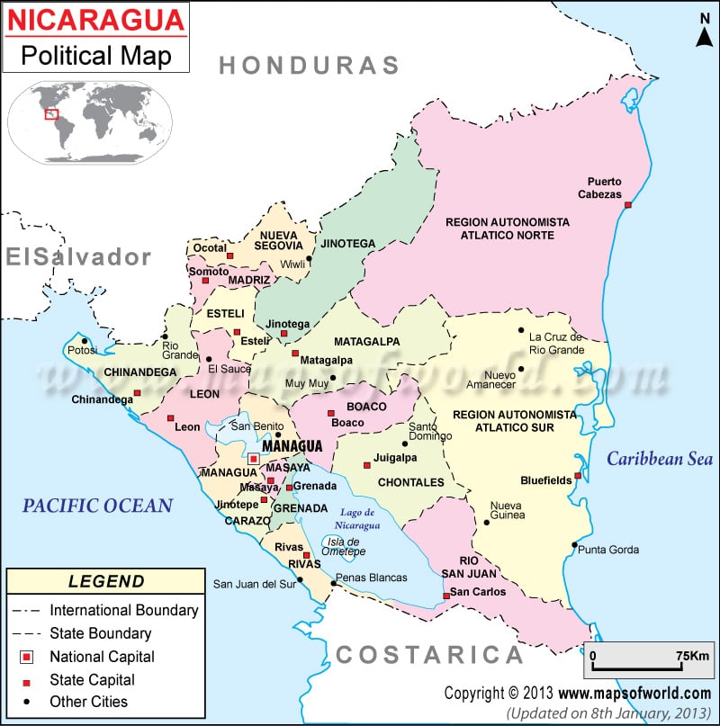
- Political Map of Nicaragua
- Where is Nicaragua
- Nicaragua Cities Map
- Nicaragua Outline Map
- River Map of Nicaragua
- Nicaragua Road Map
- Nicaragua Rail Map
- Managua Map
- Physical Map of Nicaragua
- Airports in Nicaragua
- Nicaragua Stock Exchange Map
- World Map in Spanish
- Download Free Nicaragua Political Map
- Where is Managua
- Map of Nicaragua in French
- Map of Nicaragua in Spanish
North America Lat Long Maps
- USA Lat Long Map
- Canada Lat Long Map
- Costa Rica Lat Long Map
- Bahamas Lat Long Map
- Jamaica Lat Long Map
- Mexico Lat Long Map
- El Salvador Lat Long Map
- Guatemala Lat Long Map
- Haiti Lat Long Map
- Honduras Lat Long Map
- Panama Lat Long Map
- Puerto Rico Lat Long Map
- Cuba Lat Long Map
- Greenland Lat Long Map
- Trinidad And Tobago Lat Long Map
- Dominican Republic Lat Long Map
- Belize Lat Long Map
- Barbados Lat Long Map
- Virgin Island Lat Long Map
- Falkland Islands Lat Long Map
- Cayman Island Lat Long Map
- Saint Lucia Lat Long Map
- Grenada Lat Long Map
- Dominica Lat Long Map
- Antigua Lat Long Map
- Turks Caicos Islands Lat Long Map
Latitude and Longitude Map of Nicaragua
Search For Latitude & Longitude Map
Or
Latitude
Longitude
Or
Area
* Put South & West values with minus ( - ) sign.

About latitude and longitude of Nicaragua
The latitude and longitude of Nicaragua is 13° 0' 0" N / 85° 0' 0" W. For administrative purposes Nicaragua is divided into 15 departments,and two self governing regions or autonomous committees. The 15 departments are further sub divided into 153 municipalities. Some of the major departments of Nicaragua are - Boaco, Chinandega, Nueva Segovia, Jinotega, Chontales, Matagalpa and Managua. Nicaragua’s total area is 130,370 sq km, with a land area of 119,990 sq km and water area of 10,380 sq km.
The climate of Nicaragua is tropical and features two seasons, i.e. dry and rainy season. From January to June, it is the dry season; tress and plants begin to dry out due to the lack of rains. During the rainy season which begins after July, the rains last for short periods. In the lowlands, the temperature is generally 72° F at night and 86° F at daytime.
| Location | Latitude | Longitude |
| Chontales | 12°05N | 85°24W |
| Madriz | 13°29′N | 86°35′W |
| Jinotega | 13°06′N | 86°00′W |
| Chinandega | 12°37 N | 87°09 W |
| Masaya | 11° 58' 0" N | 86° 6' 0" W |
| Estelí | 13°05′00N | 86°21′00″W |
| Boaco | 12°28′N | 85°40′W |
| Rio San Juan | 11°18′35″N | 84°41′48″W |
| Granada | 11°56′N | 85°57′W |
| Matagalpa | 12° 55' 0" N | 85° 55' 0" W |
| Carazo | 11°51′N | 86°12′W |
| Nueva Segovia | 13°45′25″N | 86°11′06″W |
| Rivas | 11°26′52″N | 85°34′17″W |
| Leon | 12°26′N | 86°53′W |
| Managua | 12°8′N | 86°15′W |
Last Updated on: February 28, 2017


