- Illinois Counties - Illinoise County Map, Map of Illinois Counties
- Major Cities of Illinois - Rockford, Springfield, Peoria, Champaign, Chicago
- Neighbouring States - Wisconsin, Iowa, Michigan, Indiana, Missouri, Kentucky
- Regional Maps - Map of USA
- Other Illinois Maps - Illinois Map, Where is Illinois, Illinois Physical Map, Illinois Lat Long Map, Illinois Zip Code Map, Illinois Area Code Map
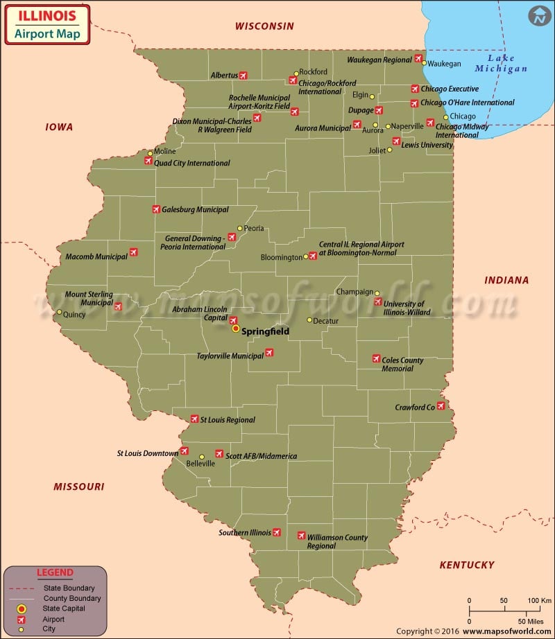
Airports in Illinois
There are 119 airports in Illinois for public use. Airports in Illinois are the gateway to a multi-cultural metropolitan America. The Illinois airports use state-of-the-art technology. Illinois’ airport systems are the second largest in USA.
Famous Airports in Illinois
Illinois attracts people from all over the globe with its booming economy and multi-cultural metropolis. The airports in Illinois are among the top airports in USA. Some of the international airports in Illinois are the Chicago O’Hare International Airport, Chicago Midway International Airport, Quad City International Airport, Clow International Airport, Lawrenceville-Vincennes International Airport and the Chicago/Rockford International Airport.
Chicago O’Hare International Airport has almost 40 airlines operating from its premises. It was ranked as the busiest airport in the world in 2005. Some of the prominent airlines are United Airlines, Northwest Airlines, Delta airlines, Japan Airlines, American Airlines, Air France and Air Canada. The airport has many convenience stores, snack bars, restaurants and a full-fledged business center for the time-conscious business people.
The Greater Peoria Regional Airport’s amenities include wireless Internet, a business lounge, ATMs, two conference rooms, shuttle bus services, restaurants and gift shops. The airlines that operate from the Peoria airport are Allegiant Air, American Eagle, Delta Connection, Northwest Airlink and United Express.
One can book one’s airline tickets online at the sites of the above-mentioned airlines and receive bonus points for flying with some of them.
Some of the other airports in Illinois are in Rock Ford, Freeport, Sterling, Aurora, Joliet, Kankakee, La Salle, Moline, Bloomington, Macomb, Quincy, Jacksonville, Springfield, Decatur, Alton, Lawrenceville, Olney, Carbondale, and Harrisburg.
Maps of Major Airports in Illinois
- Chicago O’Hare International Airport Map
- Chicago Midway International Airport Map
- Quad City International Airport Map
- Clow International Airport Map
- Lawrenceville Vincennes International Airport Map
List of Airports in Illinois
| Airport Name | Code | City | Hub | Enplanements (2015) |
|---|---|---|---|---|
| Chicago O’Hare International | ORD | Chicago | L | 36,305,668 |
| Chicago Midway International | MDW | Chicago | L | 10,830,850 |
| Quad City International | MLI | Moline | N | 368,114 |
| General Downing – Peoria International | PIA | Peoria | N | 318,162 |
| Central IL Regional Airport at Bloomington-Normal | BMI | Bloomington-Normal Airport | N | 186,633 |
| Chicago/Rockford International | RFD | Rockford | N | 108,379 |
| Abraham Lincoln Capital | SPI | Springfield | N | 90,413 |
| University of Illinois-Willard | CMI | Savoy | N | 89,836 |
| Williamson County Regional | MWA | Marion | N | 10,570 |
| Scott AFB/Midamerica | BLV | Belleville | None | 32,589 |
| Galesburg Municipal | GBG | Galesburg | None | 2,100 |
| St Louis Downtown | CPS | Cahokia | None | 1,987 |
| Chicago Executive | PWK | Wheeling | None | 1,351 |
| Southern Illinois | MDH | Carbondale | None | 281 |
| Dupage | DPA | DuPage (County) | None | 165 |
| Coles County Memorial | MTO | Mattoon | None | 148 |
| Crawford Co | RSV | Robinson | None | 95 |
| Waukegan Regional | UGN | Waukegan | None | 89 |
| Macomb Municipal | MQB | Macomb | None | 82 |
| St Louis Regional | ALN | Alton | None | 68 |
| Lewis University | LOT | Romeo (RR name for Romeoville) | None | 43 |
| Mount Sterling Municipal | I63 | Mount Sterling | None | 24 |
| Aurora Municipal | ARR | Aurora | None | 10 |
| Rochelle Municipal Airport-Koritz Field | RPJ | Rochelle | None | 10 |
| Dixon Municipal-Charles R Walgreen Field | C73 | Dixon | None | 4 |
| Taylorville Municipal | TAZ | Taylorville | None | 4 |
| Albertus | FEP | Freeport | None | 2 |
 Wall Maps