2.1K
Mountain Peaks in La Salle County
| Mountain Peak/Hill | Elevation [Meter] |
|---|---|
| Buffalo Rock | 169 |
| Piety Hill | 189 |
| Starved Rock | 167 |
More Maps of La Salle County
Airports in La Salle County
| Airport Name |
|---|
| Abie Sky Ranch Airport |
| Ambler – Cady Airport |
| B & C Airport |
| Cody Port RLA Restricted Landing Area |
| Community Hospital of Ottawa Heliport |
| Cushing Field Ltd Airport |
| David Gillespie Airport |
| Earlville Airport |
| Egland Field |
| Entwistle Airport |
| Flaherty Field |
| Frings Airport |
| Gerald H Hamer Airport |
| Grandpas’ Farm Mendota Airport |
| Hagi Landing Area Airport |
| Harrington Farms Airport |
| Hartenbower Hectares Airport |
| Hemmingsen Airport |
| Humm Airport |
| Illinois Valley Community Hospital Heliport |
| Illinois Valley Community Hospital Heliport |
| Illinois Valley Regional-Walter A Duncan field |
| Jim Wehrli Memorial Airport |
| Johnson Airport |
| Mendota Community Hospital Heliport |
| Orum Aerodrome |
| Pike’s Airport |
| Prairie Lake Hunt Club Airport |
| Rees Field |
| Rothrock Airport |
| Skydive Chicago Airport |
| Spring Brook Airport |
| St Mary’s Hospital – Streator Heliport |
| Trovero Airport |
| Walnut Creek Airport |
| Wilts Airport |
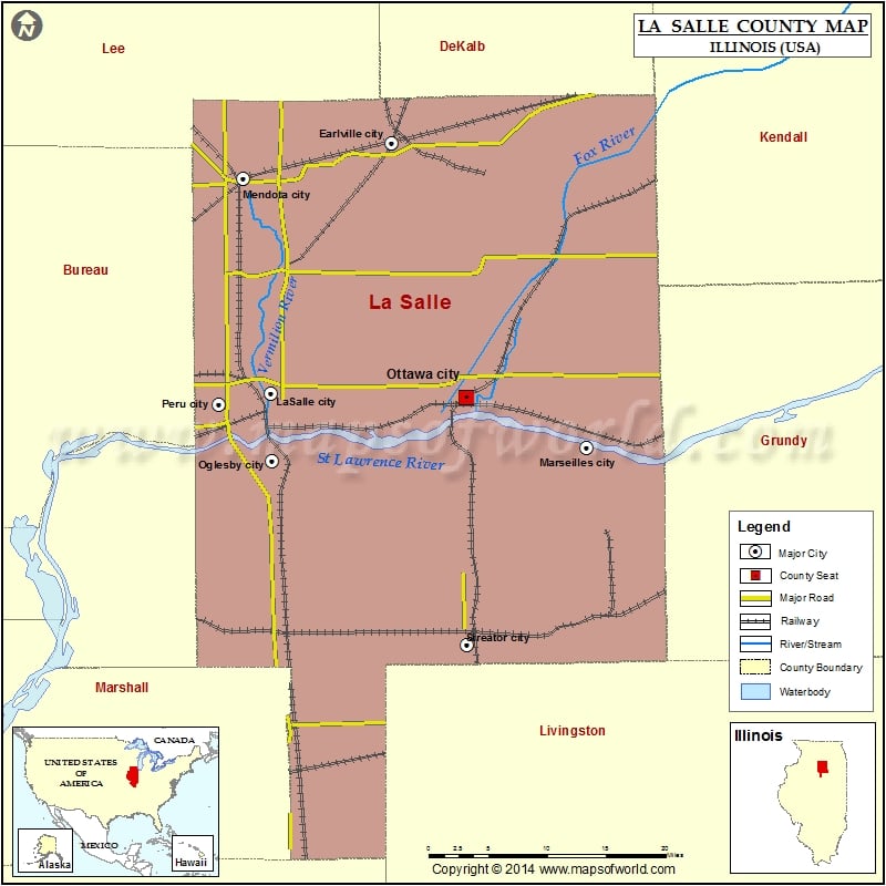
Cities in La Salle County
| City | Population | Latitude | Longitude |
|---|---|---|---|
| Cedar Point village | 277 | 41.26511 | -89.126016 |
| Dana village | 159 | 40.956508 | -88.949973 |
| Dayton | 537 | 41.385619 | -88.795824 |
| Earlville city | 1701 | 41.588064 | -88.922932 |
| Grand Ridge village | 560 | 41.236136 | -88.831029 |
| Kangley village | 251 | 41.148002 | -88.872088 |
| Lake Holiday | 4761 | 41.615569 | -88.670299 |
| LaSalle city | 9609 | 41.357447 | -89.071411 |
| Leland village | 977 | 41.61596 | -88.798305 |
| Leonore village | 130 | 41.188902 | -88.982274 |
| Lostant village | 498 | 41.140213 | -89.061406 |
| Marseilles city | 5094 | 41.308123 | -88.684323 |
| Mendota city | 7372 | 41.555192 | -89.104646 |
| Millington village | 665 | 41.562212 | -88.602534 |
| Naplate village | 496 | 41.332074 | -88.878259 |
| North Utica village | 1352 | 41.3537 | -89.010847 |
| Oglesby city | 3791 | 41.295804 | -89.069294 |
| Ottawa city | 18768 | 41.353195 | -88.831924 |
| Peru city | 10295 | 41.348047 | -89.135175 |
| Ransom village | 384 | 41.158562 | -88.654186 |
| Rutland village | 318 | 40.983795 | -89.041329 |
| Sheridan village | 2137 | 41.528453 | -88.678995 |
| Streator city | 13710 | 41.125016 | -88.83037 |
| Tonica village | 768 | 41.21587 | -89.069956 |
| Troy Grove village | 250 | 41.465701 | -89.081542 |
Golf Courses in La Salle County
| Name of Golf Course | Latitude | Longitude |
|---|---|---|
| Anderson Field Golf Course-Streator | 41.142218 | -88.835691 |
| Dayton Ridge Golf Club-Ottawa | 41.379804 | -88.816603 |
| Deer Park Country Club Inc-Oglesby | 41.29819 | -89.025771 |
| Earlville Country Club-Earlville | 41.58934 | -88.917739 |
| Mendota Golf Club-Mendota | 41.546339 | -89.16752 |
| Pine Hills Golf Club-Ottawa | 41.296965 | -88.843355 |
| Prairie Lake Golf Club-Marseilles | 41.3309 | -88.696759 |
| Senica’s Oak Ridge Golf Club-La Salle | 41.333435 | -89.096855 |
| South Bluff Country Club-Peru | 41.302687 | -89.117334 |
| Streator Country Club-Streator | 41.146605 | -88.850244 |
| The Bourne-Marseilles | 41.441518 | -88.710417 |
 Wall Maps