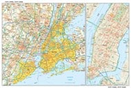
About New York City
The New York City is not only one of the most populous cities in the county, it also hosts more than 62 million visitors from within the US and from around the world every year.
The New York City is located on the banks of Hudson River, and is home to a large natural harbor. The imposing Statue of Liberty which is marked on the New York City Map, has been recognized as a symbol of the US, and is a global icon of democracy.
Home to
Columbia University, the Rockefeller University, and New York University, the city attracts a large number of foreign students and immigrants every year. Chinatown in Manhattan is the largest Chinese settlement in the western world. Referred to as the ‘city that never sleeps’, New York is a major center of art, fashion, commerce, finance, media, technology, and entertainment.
History of New York City
The City of New York traces its origins to the colonization by the Dutch in 1624. The Dutch are said to have set up a trading outpost in the region. By 1626, the Dutch named the region ‘New Amsterdam.’
The British took control of the region forty years later, in 1664. The Duke of York received a grant of the region from King Charles II, in 1676. The city and the surrounding region were then renamed New York. New York was one of the thirteen colonies to originally declare freedom from British colonial rule. New York City as depicted on the NYC Map was the capital of the United States from 1785 to 1790, and has since remained one of the largest and most influential cities of the country, and indeed the world.
When to visit New York City
Anytime of the year, the flow of tourists is steady. Since the ‘city never sleeps’, your options are many…If Broadway hits are on your list, then January-February is the best time to be in New York City. Summer is the time when the city hosts many food and cultural festivals, and stages a number of performing arts and shows. Early winter is best for budget travelers, but at Christmas the city may be at its best, and perhaps its most expensive too. New Year’s Eve at the Times Square (Manhattan) which is marked on the New York City Map is an experience broadcast around the world.
Getting to New York City and Getting Around
JFK International Airport located on the NYC Map in Queens, carries over 43 million international passengers annually. Newark Liberty International Airport, about 16 miles from Midtown, serves about 36 million passengers, both international and domestic. LaGuardia, which is also marked on the New York City Map in Queens, flies 26 million passengers, mostly domestic each year. Apart from flying, train services and ferries are good ways to reach New York City. Amtrak and Metroliner Express services connect Pennsylvania Station with Washington DC, and beyond.
The
New York City Subway, completed in 1904, is now the largest and busiest rapid transit network of the world. The bus fleet is also one of the largest in the country.
Many consider New York taxis as the way to get around town. And these drivers know the city better than anyone. What may surprise you is the vast number of people who either cycle or walk to work.
New York City, or NYC has many names, official and unofficial, known throughout the world as – The Big Apple, The City That Never Sleeps, The City So Nice They Named It Twice, Empire City, The City of Dreams, and Gotham, to name a few.
What’s in NYC ?
For someone new, or a first timer in the city, drawing up an itinerary to visit and experience the attractions of the City of New York can be a daunting task. When in New York, go ahead and be random. Follow your heart, and you are likely to find yourself enjoying the charm of the city more than following a planned itinerary. Here are some tips that will come in handy.
As depicted on the New York City Map, the Statue of Liberty needs little introduction. France’s gift to the US for the independence centennial celebrations is only a short boat ride from Manhattan. With the pedestal, the statue reaches to 305 feet. Make sure you climb all 354 steps to the top for a spectacular view. Next, head to the ‘Crossroads of the World’– indeed, we are referring to the Times Square in Manhattan which is also located on the NYC Map. Travel & Leisure Magazine thinks that the Times Square is the most-visited tourist attraction in the world. Named after Times Building, headquarters of The New York Times, this intersection in Midtown Manhattan draws 36 million visitors annually. Currently the 45th tallest building in the world, and perhaps the most famous commercial tower, is the Empire State Building, at 350 Fifth Avenue, Manhattan as shown on the New York City Map. Named among the Seven Wonders of The Modern World, the building stands 1,454 feet tall.
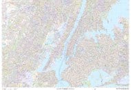
Central Park, at the heart of Manhattan, is a National Historic Landmark and is represented on the NYC Map. This 843-acre park has great boating, rock-climbing, and entertainment options. Be warned, you may not want to leave, and could spend all day here. The famed residence, The Dakota, is not far from here. Another National Historic Center in Midtown, Manhattan, is the Rockefeller Center. ‘A City in the City,’ the center is a complex of 19 buildings, and is quite famous for its large Christmas tree and ice-skating rink during the holidays.
Across the street is the St Patrick’s Cathedral, a beautiful Neo-Gothic structure that is the seat of the archbishop of the Roman Catholic Archdiocese in New York. Not to be missed, the financial district in Lower Manhattan, and Wall Street. The New York Stock Exchange, the world’s largest, is located on Wall Street, where you can feel the pulsating excitement of being in the world’s financial hub.
Where does the average Manhattan art-lover go to study over two million artifacts from different historic eras? The MET, or the
Metropolitan Museum of Art, is a world class collection and must see. Not far, in Turtle Bay, Manhattan, is the United Nations Headquarters which is shown on the New York City Map, the center of international politics and economic-social development. Lincoln Center for Performing Arts at the Lincoln Square in Manhattan, built in 1962, is home of Philharmonic Hall. The Metropolitan Opera House, and the New York Public Library for the Performing Arts, are parts of the Center which has hosted many performances.
Art lovers never feel out of place at the MoMA, the Museum of Modern Art, in Midtown Manhattan. MoMA houses one of the most astounding collections of modern art, and modern art library, in the world. The American Museum of Natural History has a collection of over 32 million display pieces – all about the natural history of the Earth. With over 46 exhibition halls, the museum has its own research facility and a library.
Another museum sure to delight is the Museum of the City of New York. Facing Central Park which can be located on the NYC Map in Manhattan, this is where you’ll learn about the history, growth, and evolution of the state & the city, and about its cultural legacy. New York City Hall in Lower Manhattan is also on the National Register of Historic Places. This is still the office of the Mayor of New York, though most other city agencies are now in the nearby Manhattan Municipal Building.
Washington Square Park is another park in the city worth a visit in Manhattan and is shown in the New York City Map. It is 9.75 acres of lush greenery, cultural activity, and entertainment. The park is a favorite hangout for the city’s local artists, some of whom also work from here.
Bryant Park is a beautiful 9.6-acre park managed by the non-profit organization, Bryant Park Corporation. The New York Public Library forms the eastern boundary of the park, and has its main entrance on the Sixth Avenue.
The world’s tenth most visited tourist attraction is a train station in NYC. The Grand Central Station Terminal attracts nearly 21 million visitors annually, in addition to train passengers, according to Travel & Leisure Magazine. Shop at the markets and malls here such as the Manhattan Mall, take pictures, and don’t forget to look up at the ornate ceiling.
The Brooklyn Bridge is located on the New York City Map and is one of the biggest attractions, and they don’t come much bigger! The oldest suspension bridge in the country, the bridge spans over 1,595 feet to connect Brooklyn and Manhattan across the East River. The bridge was named a National Historic Civil Engineering Landmark in 1972, besides being designated a National Historic Landmark in 1964.
Brooklyn’s second largest attraction is right next to the Botanic Garden, the Brooklyn Museum which is represented on the NYC Map. This museum is New York City’s second largest museum and is outdone only by the MET. It is now home to over 1.5 million art pieces and paintings.
For some outdoor activity, the roller coaster rides of Coney Island which is located on the New York City Map south of Brooklyn, the beach, and the regular shows hosted here are a ‘must see.
What to do in New York City?
New York City is a heady place of exciting activities. Central Park which is located on the NYC Map itself could bewilder you with its many options for your entertainment. Take a picnic or join impromptu in ice skating, rock climbing, watching jugglers and entertainers, or hiring a bike – the sky’s the limit. Young children are sure to enjoy the Nintendo World Store in Rockefeller Center.
Shopping along Fifth Avenue is a treat for many and is an experience you are unlikely to forget. With the international brands, the glitz and colors, Fifth Avenue may well be the Champs Elysées of the US. Broadway musicals are perennial favorites too! Catch West Side Story, Les Miserables, or A Chorus Line if they are playing. You can book in advance or buy ‘day of’ tickets at steep discounts. Visit Ground Zero and light a candle at the WTC Memorial.
If you love international food, and like trying different cuisines, New York City is your Mecca. Make your way to the South Street Seaport area and hit some of the best restaurants and nightclubs in the region. While you’re there, explore SoHo (a neighborhood in Lower Manhattan, New York City) and discover a hidden world of lively boutiques, art galleries, and local outlets.
| Counties | Bronx, Kings (Brooklyn), New York (Manhattan), Queens, Richmond (Staten Island) |
| Area | 468 sq miles |
| Population | 8.538 million (2016) |
| Districts | 5 boroughs and 59 community districts |
| Average Summer Temperature | 73°F |
| Average Winter Temperature | 45°F |
| Dialing Code | Country 1 City 212 |
| Zip Code | 100xx–104xx, 11004–05, 111xx–114xx, 116xx |
| Major Airports | John F Kennedy International Airport (JFK); Newark Liberty International Airport (EWR); LaGuardia Airport (LGA) |
| Lat Long of NYC | 40°71′ N, 74°00′ W |
| Time Zone | North American Eastern Time Zone |
| Official Website | www.nyc.gov |
Cities near New York Metropolitan Area: |
|---|
| New York, NY | North Bergen, NJ |
| Hoboken, NJ | Edgewater, NJ |
| Weehawken, NJ | Cliffside Park, NJ |
| Guttenberg, NJ | Floral Park, NY |
| West New York, NJ | North Valley Stream, NY |
| Union City, NJ | Valley Stream, NY |
| Elmont, NY | Jersey City, NJ |
| Fairview, NJ | |