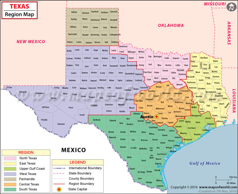
Regions in Texas
Due to its location and size, the state of Texas features unique geological regions that range from the piney woods of East Texas to the mountains in far West Texas. Here are the seven vernacular regions in the Lone Star State –
East Texas
The region extends from northeastern Oklahoma and Louisiana borders to as far south as the Galveston Bay along the upper Gulf Coast. Palestine, Jacksonville, and Mount Pleasant are major cities in the region. Culturally, the region has similarities with the Deep South. The East Texas Oil Field is one of the largest oil fields in America. East Texas is famous for Antebellum architecture, Piney Woods, and Robert Earl Keen classics.
Upper Gulf Coast
The region features the city of Houston and its 13 neighboring counties, which is not considered a part of East Texas. The region is also distinct from the Lower Gulf Coast which falls under South Texas.
North Texas
Also referred to as North Central Texas and Nortex, the region lies south of Oklahoma border, east of Abilene, and north of Waco. It is centered around the Dallas-Fort Worth Metroplex – the country’s largest inland metropolitan area. The city of Dallas boasts the largest arts district in the US, and the city is bonded by 30 miles of suburbs with the city of Fort Worth.
Texas Pandhandle
The Panhandle region – which is further northwest – is distinct from North Texas. It comprises the northernmost 26 counties (between borders of New Mexico and Oklahoma) of Texas. Amarillo is the largest city in the region.
Central Texas
The region features the Texas Hill Country, Edwards Plateau, and Texas blackland prairies. Austin – the capital of Texas – is located in the region. It is famously known as “Live Music Capital of the World”. Other major cities include College Station, Killeen, Round Rock, Mansfield, and Waco.
West Texas
The upper Panhandle is culturally similar to Midwest instead of either the South or Southwest. What lies west of the Pecos River is known as “Far West Texas”, or the “Trans-Pecos”. Being the most arid portion in Texas, it has lower population density than the state average. El Paso, Lubbock, Abilene, and Odessa are major cities in West Texas.
South Texas
From the Texas Coastal Bend to the Hill Country, the region defines the area south of (and including) San Antonio – the largest city in the region. Being near the border of Mexico, it has notable Hispanic cultural influences. The Rio Grande forms its southwestern boundary. McAllen, Mission, Edinburg, Pharr, and Harlingen are major cities in the region. It features the 113-mile Padre Island, which is the longest barrier island in the world.
 Wall Maps