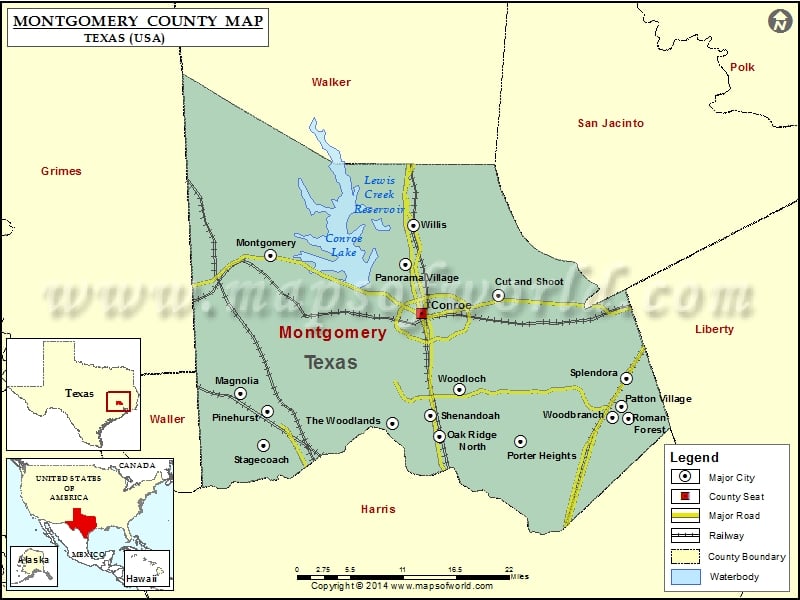
About Montgomery County
Montgomery County is a county located in the southeastern part of the state of Texas, and its county seat is Conroe. The area is known for its strong economy, with a focus on healthcare, education, and oil and gas production. The county is also home to several higher education institutions, including Lone Star College-Montgomery and Sam Houston State University. The Montgomery County map shows major highways and transportation networks that connect the area to other parts of Texas and the United States.
The region offers a high quality of life with excellent schools, parks, and cultural amenities, and is a popular destination for outdoor recreation and entertainment, with attractions such as Lake Conroe and the W.G. Jones State Forest.
Mountain Peaks in Montgomery County
| Mountain Peak/Hill | Elevation [Meter] |
|---|---|
| Crater Hill | 48 |
| Shepard Hill | 94 |
More Maps of Montgomery County
- Montgomery County Map, Alabama
- Montgomery County Map, North Carolina
- Montgomery County Map, Tennessee
- Montgomery County Map, Georgia
Airports in Montgomery County
| Airport Name |
|---|
| Gdap Air Ranch Airport |
| H Young Ranch Airport |
| Lake Bonanza Airport |
| Lawrence Administrative Services Inc Heliport |
| Lone Star Executive Airport |
| Mabry AHP /NG/ Heliport |
| Marmack Airport |
| Memorial Hospital-The Woodlands Heliport |
| Montgomery Co Law Enforcement Cntr Heliport |
| Montgomery County Medical Center Hospital Heliport |
| Outlaw Flyers Airport |
| Sartor Heliport |
| Tgp 25 Heliport |
| Williams Airport |
Cities in Montgomery County
| City | Population | Latitude | Longitude |
|---|---|---|---|
| Conroe city | 56207 | 30.31677 | -95.469869 |
| Cut and Shoot City | 1070 | 30.340371 | -95.353797 |
| Magnolia city | 1393 | 30.211731 | -95.741889 |
| Montgomery city | 621 | 30.39175 | -95.696409 |
| Oak Ridge North city | 3049 | 30.156777 | -95.442144 |
| Panorama Village city | 2170 | 30.380889 | -95.494389 |
| Patton Village city | 1557 | 30.195593 | -95.169644 |
| Pinehurst | 4624 | 30.188885 | -95.701667 |
| Porter Heights | 1653 | 30.14988 | -95.321686 |
| Roman Forest town | 1538 | 30.179366 | -95.159354 |
| Shenandoah city | 2134 | 30.183781 | -95.455516 |
| Splendora city | 1615 | 30.232492 | -95.161579 |
| Stagecoach town | 538 | 30.143882 | -95.707861 |
| The Woodlands | 93847 | 30.173703 | -95.513474 |
| Willis city | 5662 | 30.425851 | -95.482339 |
| Woodbranch city | 1282 | 30.181405 | -95.183435 |
| Woodloch town | 207 | 30.217223 | -95.413207 |
Golf Courses in Montgomery County
| Name of Golf Course | Latitude | Longitude |
|---|---|---|
| April Sound Golf Course-Montgomery | 30.371525 | -95.611222 |
| Bentwater Country Club-Montgomery | 30.424705 | -95.626978 |
| Blaketree National Golf Club-Montgomery | 30.30892 | -95.771124 |
| Canongate At Lake Windcrest Golf Club-Magnolia | 30.219862 | -95.602993 |
| Canongate At the Woodlands-The Woodlands | 30.148151 | -95.473846 |
| Conroe Country Club-Conroe | 30.322211 | -95.501254 |
| Grand Lake Golf Club-Montgomery | 30.280357 | -95.643001 |
| High Meadow Ranch Golf Club-Magnolia | 30.163889 | -95.732581 |
| La Torretta Del Lago Resort-Montgomery | 30.402205 | -95.648033 |
| Oakhurst Golf Club-Porter | 30.086537 | -95.25806 |
| River Plantation Country Club-Conroe | 30.255893 | -95.441039 |
| Texas National Golf Club-Willis | 30.416856 | -95.44256 |
| The Club At Carlton Woods-The Woodlands | 30.194121 | -95.54841 |
| The Links At West Fork-Conroe | 30.330917 | -95.515857 |
| The Village Golf Club-Conroe | 30.377845 | -95.493477 |
| The Woodlands Country Club Arnold Palmer-The Woodlands | 30.188888 | -95.519708 |
| The Woodlands Country Club Gary Player-The Woodlands | 30.185138 | -95.546977 |
| The Woodlands Country Club Tournament Course-The Woodlands | 30.143436 | -95.462736 |
| Walden Golf & Country Club-Montgomery | 30.396065 | -95.624248 |
| Wedgewood Golf Course-Conroe | 30.339939 | -95.520926 |
| Woodforest Golf Club At Fish Creek-Montgomery | 30.27881 | -95.571369 |
 Wall Maps