2.1K
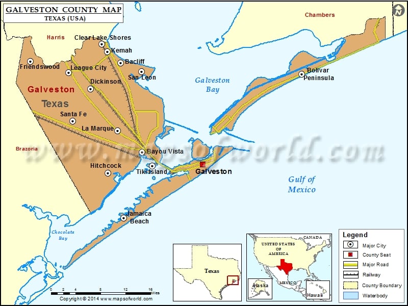
Check this Texas County Map to locate all the state’s counties in Texas Map.
Airports in Galveston County
| Airport Name |
|---|
| Austinia Airport |
| B & S Ultralightport |
| Bay Electric Supply Heliport |
| Creasy Airport |
| Diehl Ranch Airport |
| Dresser Industries/Magcobar/ Heliport |
| Golden Pegasus Ranch Heliport |
| Hhi Hitchcock Heliport |
| Hhi Hitchcock Heliport |
| Houston Airport |
| Houston Oil & Minerals Port Bolivar Heliport |
| Houston Oil & Minerals Port Bolivar Nr 2 Heliport |
| Johnnie Volk Field |
| Kami-Kazi Airport |
| Kemah Waterfront Heliport |
| Laseair Airport |
| Mainland Regional Health Care System Heliport |
| Mickler Heliport |
| Midstream Galveston Helipad Area Nr 1 Heliport |
| Midstream Galveston Helipad Area Nr 2 Heliport |
| Old Forker Ultralightport |
| Polly Ranch Airport |
| Rebel Field |
| Republic Helicopters Heliport |
| San Luis Resort Heliport |
| Scholes International At Galveston Airport |
| Seafood Warehouse Park Airport |
| Shell Pelican Island Heliport |
| Tdcj/Southern Regional Medical Facility Heliport |
| Tourist Ride Services Heliport |
| U of Texas Medical Branch Emergency Room Heliport |
| U of Texas Medical Branch Ewing Hall Heliport |
Cities in Galveston County
| City | Population | Latitude | Longitude |
|---|---|---|---|
| Bacliff | 8619 | 29.507725 | -94.987862 |
| Bayou Vista city | 1537 | 29.325707 | -94.938858 |
| Bolivar Peninsula | 2417 | 29.484714 | -94.567235 |
| Clear Lake Shores city | 1063 | 29.545706 | -95.032759 |
| Dickinson city | 18680 | 29.454011 | -95.05864 |
| Friendswood city | 35805 | 29.510878 | -95.198015 |
| Galveston city | 47743 | 29.243906 | -94.856543 |
| Hitchcock city | 6961 | 29.282433 | -95.018453 |
| Jamaica Beach city | 983 | 29.191338 | -94.980682 |
| Kemah city | 1773 | 29.530587 | -95.019495 |
| La Marque city | 14509 | 29.368955 | -94.99564 |
| League City city | 83560 | 29.4873 | -95.108986 |
| San Leon | 4970 | 29.489442 | -94.939638 |
| Santa Fe city | 12222 | 29.389038 | -95.099686 |
| Texas City city | 45099 | 29.44745 | -94.894173 |
| Tiki Island village | 968 | 29.297531 | -94.914506 |
Golf Courses in Galveston County
| Name of Golf Course | Latitude | Longitude |
|---|---|---|
| Bayou Golf Club-Texas City | 29.415847 | -94.976931 |
| Beacon Lakes Golf Club-Dickinson | 29.47479 | -95.077868 |
| Canongate At Magnolia Creek Golf Course-League City | 29.476906 | -95.145452 |
| Canongate of South Shore-League City | 29.533859 | -95.052298 |
| Chapparral Rec Assoc Golf Club-Dickinson | 29.434786 | -95.079811 |
| Galveston Country Club-Galveston | 29.20768 | -94.94779 |
| Green Caye Golf Course-Dickinson | 29.481996 | -95.026834 |
| Moody Gardens Golf Course-Galveston | 29.264766 | -94.868676 |
| Rancho Carribe Golf Course-Crystal Beach | 29.433828 | -94.68037 |
 Wall Maps