North America Map
Explore the map of North America, the third largest by area and the fourth most populated continent in the world. It comprises the North American peninsula, Central America, and the Caribbean. It is located in the northern hemisphere between the Pacific Ocean and the Atlantic Ocean and is home to some major global economies like the United States and Canada. To explore more about the continents, check out our Continents Map.

-
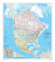
North America Wall Map
$20.99
-
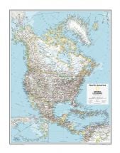
North America Political Map
$26.99
-
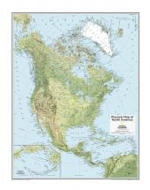
North America Physical Map
$26.99
| Disclaimer |
×
Disclaimer : All efforts have been made to make this image accurate. However MapSherpa, Inc, its directors and employees do not own any responsibility for the correctness or authenticity of the same.
About North America Map: Spread over 9.5 million sq miles, North America is the 3rd largest continent in the world. This huge continent consists of 23 independent states and 25 dependent territories. The map notes all the capital cities such as Washington D.C., Ottawa, Guatemala, Mexico City, Managua, San Salvador, Havana, Panama City, San Jose, Belmopan, Kingston, Tegucigalpa, Santo Domingo, Port-su-Prince, Nassau, and Port of Spain. The North America map also shows prominent rivers of the continent such as River Mackenzie, River Mississippi, River Missouri, and River Colorado. The important peaks such as Mt. Whitney, Mt. Washington, Mt. Hood, Mt. Mitchell, Mt. Elbert, Mt. Katahdin, Mt. Baker are also noted. The key landforms such as the Rocky Mountains, Appalachian Mountains, the Great Basin, the Edwards Plateau, the Sierra Madre, the Caribbean island nations, the Colorado Plateau, and the Pacific and Atlantic coastal regions are also displayed.


