How Deep is Lake Superior?
Lake Superior is the largest of North America’s Great Lakes. The lake is famous for its natural beauty and clear, deep, cold waters. In this article, we will explore how deep the lake is superior, where it is and more.
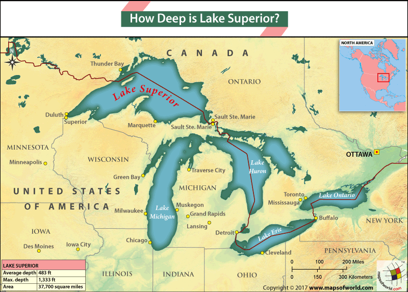
Depth of Lake Superior
Lake Superior has an average depth of about 483 feet (147 meters). Its maximum depth is approximately 1,332 feet (406 meters), which is near the eastern end of Grand Island in the northern part of the lake. This area is known as the “Southwest Point of the lake” and is located offshore from the town of Munising, The minimum depth of Lake Superior can vary widely across different areas of the lake, but it generally ranges from a few feet to around 30 feet (9 meters).
Where is Lake Superior?
Lake Superior is located in central North America. It is situated between the Canadian province of Ontario to the north and east, and the U.S. states of Minnesota to the west, and Wisconsin and Michigan to the south.
How Lake Superior Formed?
The formation of Lake Superior is a result of a combination of complex geological processes, including glaciation and the shaping of the landscape over millions of years. Lake Superior has its origins in the North American Mid-Continent Rift of 1.1 to 1.2 billion years ago.
- Lake Superior was formed by glaciers during the Pleistocene Epoch, which began about 2.6 million years ago. It ended around 11,700 years ago. These massive ice sheets, which covered much of North America, moved southward from Canada, scouring the landscape and creating large basins.
- Due to global warming over the years the glaciers began to retreat. Large volumes of meltwater filled the basins left behind by the ice. This meltwater, along with precipitation, gradually formed the Great Lakes, including Lake Superior.
- Ancient Precambrian rock primarily composes the bedrock underlying Lake Superior, making it among the oldest on Earth. This durable rock contributes to the lake’s clear, clean water and rugged shoreline.
Comparison with Other Great Lakes
When comparing Lake Superior with the other Great Lakes – Michigan, Huron, Erie, and Ontario, we can look at several key parameters:
- Size: Lake Superior is the largest of the Great Lakes by surface area, covering about 31,700 square miles (82,100 square kilometers). Lake Michigan-Huron, is the second-largest, with a combined surface area of about 45,300 square miles (117,400 square kilometers).
- Depth: Lake Superior is also the deepest of the Great Lakes, with a maximum depth of approximately 1,332 feet (406 meters). Lake Michigan is the second-deepest, with a maximum depth of 923 feet (281 meters).
- Volume: Lake Superior ranks second in volume among the Great Lakes, holding about 2,900 cubic miles (12,100 cubic kilometers) of water. Lake Michigan-Huron has the greatest volume, containing approximately 4,920 cubic miles (20,500 cubic kilometers) of water.
- Water Clarity: Lake Superior is known for its exceptionally clear water, with visibility reaching up to 27 feet (8.2 meters) in some areas. The other Great Lakes generally have lower water clarity due to higher levels of algae and other impurities.
- Temperature: Lake Superior’s large volume and depth contribute to its relatively cooler temperatures compared to the other Great Lakes. Surface temperatures rarely exceed 60°F (15.5°C) even in the summer, while the other lakes can have warmer surface temperatures.
Interesting Facts about Lake Superior
- Lake Superior is the world’s largest freshwater lake by surface area and holds 10% of the planet’s freshwater supply.
- The lake is home to numerous species of fish, including lake trout, walleye, and whitefish.
- Various Native American tribes, including the Ojibwe, Chippewa, and Sioux, originally inhabited it.
- European explorers first arrived in the Lake Superior area in the 17th century. The fur trade flourished along the lake’s shores.
Related Links