Africa Physical Map
Physical Map of Africa displays relief, plateaus, rivers, intermittent streams, mountain peaks, plains, and other topographic features of Africa. Africa is a geographically diverse continent situated across the equator, characterized by large deserts, mountain ranges, and coastal plains.
Search Physical Maps of Continents & Countries
Physical map of
Continents
and
Countries
- Algeria
- Angola
- Benin
- Botswana
- Burkina Faso
- Burundi
- Cameroon
- Cape Verde
- Chad
- Democratic Republic of The Congo
- Egypt
- Eritrea
- Ethiopia
- Kenya
- Lesotho
- Libya
- Madagascar
- Mali
- Mauritania
- Mauritius
- Morocco
- Mozambique
- Namibia
- Niger
- Nigeria
- Somalia
- South Africa
- Sudan
- Tanzania
- Uganda
- Zimbabwe
- Afganistan
- Armenia
- Bangladesh
- Bhutan
- Brunei
- China
- India
- Indonesia
- Iran
- Iraq
- Israel
- Japan
- Jordan
- Kazakhstan
- Kuwait
- Kyrgyzstan
- Laos
- Lebanon
- Malaysia
- Mongolia
- Myanmar
- Nepal
- North Korea
- Pakistan
- Philippines
- Qatar
- Russia
- Russia
- Saudi Arabia
- Singapore
- South Korea
- Srilanka
- Syria
- Thailand
- Turkey
- United Arab Emirates
- Uzbekistan
- Vietnam
- Albania
- Andorra
- Austria
- Belarus
- Belgium
- Bosnia and Herzegovina
- Bulgaria
- Croatia
- Cyprus
- Czech Republic
- Denmark
- England
- Estonia
- Finland
- France
- Georgia
- Germany
- Greece
- Hungary
- Iceland
- Ireland
- Italy
- Kosovo
- Latvia
- Lithuania
- Luxembourg
- Malta
- Montenegro
- Netherlands
- Netherlands
- Norway
- Poland
- Portugal
- Romania
- Serbia
- Slovakia
- Slovenia
- Spain
- Sweden
- Switzerland
- Turkey
- United Kingdom
- Ukraine
- Antigua and Barbuda
- Barbados
- Belize
- Canada
- Costa Rica
- Cuba
- Dominican Republic
- El Salvador
- Grenada
- Guatemala
- Haiti
- Honduras
- Jamaica
- Mexico
- Nicaragua
- Panama
- Trinidad and Tobago
- United States of America
- Argentina
- Bolivia
- Brazil
- Chile
- Colombia
- Ecuador
- Paraguay
- Peru
- Uruguay
- Venezuela
- Australia
- Fiji
- New Zealand
- Papua New Guinea


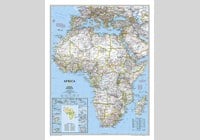
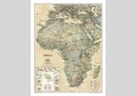
| Description : Africa physical map provides detailed information on the various physical features of the continent. | Disclaimer |
×
Disclaimer : All efforts have been made to make this image accurate. However MapSherpa, Inc, its directors and employees do not own any responsibility for the correctness or authenticity of the same.


