- Neighboring Countries - Mongolia, Kazakhstan, Ukraine, Poland, Belarus, Finland
- Continent And Regions - Europe Map
- Other Russia Maps - Russia Map, Where is Russia, Russia Blank Map, Russia Road Map, Russia Rail Map, Russia River Map, Russia Cities Map, Russia Political Map, Russia Flag
Russia is a transcontinental country spanning Northern Asia and Eastern Europe. The country is the largest globally, having a total area of over 17,125,191 square kilometres (6,612,073 sq mi).
Physical Features of Russia
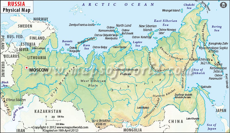
Moscow is the largest city, and the capital of Russia marked on the map. A map legend at the bottom helps all the signs, characters, graphics, and symbols used throughout the map. The Russia Physical map can be used for school presentations and other purposes.
Russia lies between latitudes 41. N and 82. N and longitude19. E and 169. E. Russia encompasses one-eighth of the Earth’s inhabitable landmass and shares a boundary with sixteen sovereign nations. Geographically the country is divided into five zones: Tundra Zone, Taiga Zone or forest, Steppe Zone or Plains, Arid Zone, and the Mountain Zone. Some of the essential physical features of Russia are:
East European Plain and West Siberian Plain
The East European Plain is an interior plain extending east of the North European Plain consisting of several plateaus. The region includes Central Russian upland, Volhynian-Podolian Upland and Volga Upland. The Plain is comprised of a series of significant river basins such as the Volga basin, Oka-Don Lowland and Dnepr Basin.
West Siberian Plain is a vast plain in the western portion of Siberia. The plain lies between the Yenisei River in the east, the Ural Mountains in the west, and the Atlas Mountains in the southeast. Significant cities include Tomsk, Omsk, Chelyabinsk and Novosibirsk.
Lowlands
- North Siberian Lowland or Taymyr lowland is a flat relief feature separating the Central Siberian Plateau in the south from the Byrranga Mountains of the Taymyr Peninsula in the north.
- Central Yakutian lowland or Vilyuy lowland is an extensive alluvial Plain located in the transition zone between Eastern and Central Siberia.
- East Siberian lowland is a large plain in northeastern Siberia. It is also known as the Yana-Kolyma lowland.
Central Siberian Plateau and Lena Plateau
- Central Siberian Plateau is a vast region in central Siberia between Lena and Yenisei Rivers. The plateau lies in the Siberian Platform and covers one-third of Siberia.
- Lena Plateau or Prilensky Plateau is named after River Lena and is located in the southern Sakha Republic between the Amga River in the east and to lower Tunguska River in the west.
East Siberian Mountains and South Siberian Mountains
- East Siberian Highlands are located between the Bering Strait in Northeast Siberia and Central Yakutian Lowland. This series of mountain ranges rise to the south and north of the Arctic Circle. Some of the contents are Verkhoyansk Range, Suntar-Khayata Range, kyundyulyun, Chersky Range, Yana-Oymyakon Highlands and more.
- South Siberian Mountains are located along the southern border of Russia’s Siberian and Far Eastern Federal Districts. Some of the significant ranges are the Altai Mountains, Salair Ridge, Sayan Mountains, Khentei-Daur Highlands, Stanovoy Highlands, North Baikal Highlands and more.
Ural Mountains
The Urals are the mountain ranges forming the northern part of the border between regions of Europe and Asia. The mountain range runs north to south through western Russia, extending about 2,500 km. The Ural” mountain rises from the Kara Sea to the Kazakh steppe along northwestern Kazakhstan.
Rivers and Lakes system in Russia
The country is home to above 100,000 rivers. Russia has one of the world’s most extensive surface water resources. The lakes contain approximately one-quarter of the world’s liquid freshwater. Three significant rivers longer than 1,000 kilometres that drain Siberia are Irtysh-Ob System(5,380 kilometres), Yensely River (5075 kilometres) and Lena River (4,294). They flow northward into the Arctic Ocean and are among the longest rivers in the world. In western Russia, significant rivers are the Pechora and the Northern Dvina. The two largest lakes in Europe, Onega and Ladoga, are located in northwestern Russia. Lake Baikal is another important lake in Russia among the other lakes in the country.
Physical Map of Neighbouring Countries
- Norway Physical Map
- China Physical Map
- Finland Physical Map
- Estonia Physical Map
- Latvia Physical Map
- Lithuania Physical Map
- Poland Physical Map
- Belarus Physical Map
- Ukraine Physical Map
- Kazakhstan Physical Map
- Mongolia Physical map
- North Korea Physical Map
- Georgia Physical Map
