- Brazil States - Acre, Alagoas, Amapa, Amazonas, Bahia, Ceara, Distrito Federal, Espirito Santo, Goias, Maranhao, Mato Grosso, Mato Grosso do Sul, Minas Gerais, Para State, Paraiba, Parana, Pernambuco, Piaui, Rio de Janeiro, Rondonia, Roraima, Santa Catarina, Sao Paulo, Sergipe, State of Rio Grande do Norte, State of Rio Grande do Sul, Tocantins
- Brazil Cities - Aracaju, Belem, Belo Horizonte, Boa Vista, Brasilia, Campo Grande, Cuiaba, Curitiba, Florianopolis, Fortaleza, Goiania, Joao Pessoa, Macapa, Maceió, Manaus, Natal, Palmas, Porto Alegre, Porto Velho, Recife, Rio Branco, Salvador, Sao Luis, Sao Paulo, Teresina, Vitoria
- Brazil Regions - Central West Region of Brazil, North Region of Brazil, Northeast Region of Brazil, South Region of Brazil, Southeast Region of Brazil
- Neighbouring Countries - Argentina, Bolivia, Colombia, Guyana, Paraguay, Peru, Suriname, Uruguay, Venezuela
- Continent And Regional Maps - South America Map, Americas Map
- Other Brazil Maps - Brazil Map, Where is Brazil, Brazil Blank Map, Brazil Political Map, Brazil Railway Map, Brazil River Map, Brazil Road Map, Brazil Flag
Brazil, known as the Federative Republic of Brazil, is the largest country in Latin America and South America. Brazil shares the boundary with all the countries in South America except Chile and Ecuador.
Physical Features of Brazil
The country covers 47.3% of the land area of the continent of South America occupying ample space along the eastern coast and much of the continent’s interior. Brazil encompasses several oceanic archipelagos such as Rocas Atoll, Saint Peter and Paul Rocks, Fernando de Noronha and Trindade and Martim Vaz.
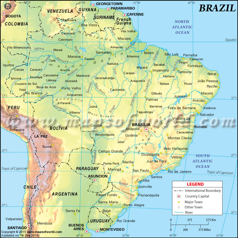
Brazil is a geographically diverse country. It lies between 6 N and 34.S and longitudes between 28. and 74.W., can be seen on the map. The capital city of Brasilia is marked on the map. The map is beneficial for school presentations. A map legend at the bottom helps all the signs, characters, graphics, and symbols. The physical features of Brazil can be divided into the following Physiographic divisions:
The Guiana Highlands in the North
The region is characterised by mountain ranges, Forested mesas, waterfalls and white-water rivers. The country shares the Guiana Highlands with Suriname, Venezuela, Guyana and French Guiana. Neblina Peak is the highest point in Brazil at an elevation of 9,888 feet (3014 metres) and is located along the Venezuelan border in the Serra do Imeri. Tumuc-Humac and Acarai are situated along the Guineas and Brazil border.
The Amazon Lowlands
The region separates Guinea Highlands in the north from Brazilian Highlands in the south. Along the eastern base of Andes, lowlands are the widest. The most prominent topographic feature of the region is Terra Firme. They are gently rolling hills made up of alluvial soil. Wetlands are Oxbow lakes and are found throughout the region.
The Pantanal in the Central-West
The region is in northwestern Mato Grosso do Sul and the southern Mato Grosso States and is marshy and swampy. The area is one of the most extensive freshwater wetlands in the world in northern Paraguay and eastern Bolivia.
Brazilian Highlands
The highlands comprise more than half of the country’s landmass. In the country, Brazilian highlands are often called Planalto Central. The highlands are rugged, including cliffs, rolling hills, flat-topped Plateau and rock outcrops. The maximum height is below 10,000 feet (3,000 metres). From the eastern coast, Along with the series of ridges, it is less than 300 miles (500 km). Goias highlands’ north and west extend for 600 miles (1,000 km). The Eastern edge of Brazilian highlands forms mountain ranges about an average elevation of 2,600 feet (800 metres) with individual peaks above 7000 feet. Major mountain ranges of the highlands are Serra Grande, Serra do Mar, Araripe Upland and more.
Coastal Lowlands
The region consists of Atlantic lowlands extending up to 125 miles (200 km) wide in the north and narrower in the Northeast. The features of coastal lowlands include level flood plains, lagoons, swamps, dunes. The lowlands widen in the south at the Patos Lagoon.
Significant Rivers of Brazil
The Amazon River is the most extensive river system globally and drains the entire country of Brazil. The river rises within 100 miles (160 km) of the Pacific Ocean from the Peruvian Andes and then meanders its course to the Atlantic.The tributaries of the River are Purus, Jurua, Madeira, Xingu River and Negro River. The other important rivers of the country are Paraguay-Parana-Plata, Tocantins-Araguaia River System.
