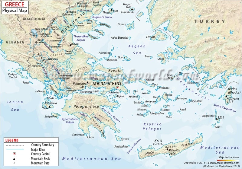
As shown in the map, Greece is bordered by Albania, Republic of Macedonia and Bulgaria to the north and Turkey to the east. The country shares maritime borders with the Aegean Sea to the east, Ionian Sea to the west, and to the south Greece is bounded by the Mediterranean Sea.
The national capital, Athens, is shown in the map marked with a red circle enclosed in a square. Home to over 655,780 people, Athens is the largest city in Greece. The capital is world renowned as a center of arts, learning, and philosophy. The Acropolis of Athens, the Daphni Monastery are the ancient monuments in the city recognized as UNESCO world heritage sites. Athens boasts of a number of such architectural places built in Greco-Roman and neo-classical styles.
Greece has a long coastline of over 8,498 miles in length. There are over 1400 islands in the country including Crete, Euboea, Ionian Islands, Rhodes, Lesbos, the Cyclades, and the Dodocanese. The physical map of Greece also shows the major rivers, lakes, and seas in Greece. Evrotas, Alfeias, Acheron, Evinos, Mornos, Glafkos, Inachos, Bisaltes, Aegean Sea, and Eurotas are some of the major water bodies marked in the physical map of Greece.
A mountainous country, almost eighty percent of Greece is covered by mountains and hills. Mount Olympus is the highest peak in the country. The other major mountain ranges in Greece as shown in the map are:
Parnassos
Psiloritis
Attavyros
Kefallonia
Thasos
Smolikas
Lakmos
Antichasia
The mountainous terrain of Greece offer a myriad of trails to explore, and mountain bike riding while the turquoise waters of Greece offer immense recreational opportunities like sailing, scuba diving, hiking and other water sports. mountain bike riding.
Last Updated : June 16, 2015