- Neighboring Countries - South Africa
- Continent And Regions - Africa Map
- Other Lesotho Maps - Lesotho Map, Where is Lesotho, Lesotho Blank Map, Lesotho Road Map, Lesotho River Map, Lesotho Cities Map, Lesotho Political Map, Lesotho Flag
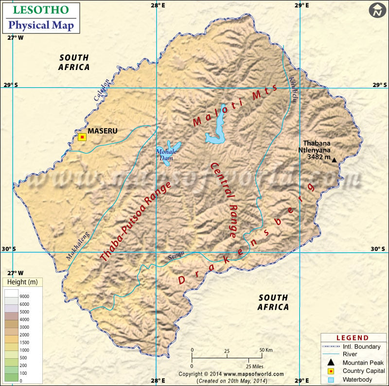
Lesotho, known as the Kingdom of Lesotho, is an enclosed country surrounded by South Africa. The Capital and largest city is Maseru which is located on the map. The country is nicknamed” Kingdom in the Sky”. The country is mainly mountainous, situated in the Maloti Mountains, and consists of the highest mountains in Southern Africa. One can point out the latitudes and longitudes of the country on the map along with the international boundary and neighboring countries.
Physical Features of Lesotho
Lesotho lies between latitudes 28.S. and 31.S and longitudes 27.E. Lethoso covers a total area of 30,355 km2 (11,720 sq mi). The country is the only state globally that lies above 1,000 meters (3281 ft) in height. The map is beneficial for school presentations and other purposes. The country can be divided into the following topographic regions:
Drakensberg range and highlands
Two-thirds of the country consists of mountains. Mount Thabana Ntlenyana is the highest peak of Lesotho at an elevation of 11,424 feet (3,482 meters) above sea level. Drakensberg range is the central mountain range of southern Africa. It forms the eastern boundary of the country with KwaZulu-Natal. Other prominent ranges located in the central and eastern parts of the country are the Maloti mountain ranges. These highlands extend for 100 km and, for me, the northern boundary between the Butha-Buthe District of Lesotho and South Africa. Maloti join the main range in the north, forming the height plateau between 9000-10,500 feet.
(2,700 to 3,200 feet).
Lowlands and Foothills in Lesotho
The lowlands are there in Senqu River Valley and the southern banks of Caledon River. The lowlands border the free state and have an average elevation of about 1,500 to 1,800 meters (6000-7,000 feet). Some foothills form the divide between Highlands and lowlands and descend towards the west in an undulating slope. They have an average elevation of about 6,000-7,000 feet (1,800-2,100 meters). The area is fertile. At the junction of the Orange (Senqu) rivers and Makhaleng rivers at the country’s border, there is the lowest elevation of Lesotho at 1,400 meters (4593 ft). It is the highest lowest point of any country.
Rivers in Lesotho
Though the country has fewer water bodies, it has the source of the two largest rivers of South Africa, the Orange River rising in the Drakensberg mountains flowing westward and the Tugela River flowing eastward. Other important rivers in the country are the Caledon River marking the northwestern part of the border, its tributaries, and the Senqu River flowing in its center. The Kometspruit River in the Southwest and Matsoku River in the northeast.
Physical Map of Neighbouring Countries

 Lesotho Population