- Neighboring Countries - Algeria, Niger, Burkina Faso, Guinea, Senegal
- Continent And Regions - Africa Map
- Other Mali Maps - Mali Map, Where is Mali, Mali Blank Map, Mali Road Map, Mali Rail Map, Mali River Map, Mali Cities Map, Mali Flag
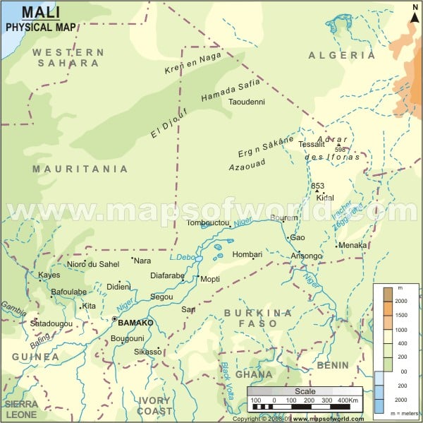
Mali, known as the Republic of Mali, is a landlocked country in West Africa. The country shares its boundary with Niger to the east, Algeria to the north-northeast, Burkina Faso to the southeast, Ivory Coast to the south, Senegal to the west, Mauritania to the northwest and Guinea to the Southwest. Mali’s largest and Capital city is Bamako, marked on the map. One can point out the latitudes and longitudes of Mali on the map along with international boundaries.
Physical Features of Mali
The country lies between latitudes 10. N and 25. N and longitudes 13. W and 5. E. The country covers a total area of 1,242,248 square kilometres (479,635 sq mi). Semi-Desert or Desert area covers about 65 % of the entire region of Mali. The landscape of Mali is mainly flat. Based on relief, Mali is divided into two topographic features:
Plateaus in Mali
The southwest and south plateaus have an average height of about 1,000 and 1,600 feet (300-500 metres). They are the extensions of the Guinea Highlands of Guinea and Cote d’Ivoire and Fouta Djallon highlands of Guinea and the Guinea Highlands. These plateaus have an elevation of about 2,000 feet (600 metres) in the Mandingue Plateau near Bamako, and it is more than 2,100 feet (640 metres) near Satadougou. In comparison, the plateaus of the east and southeast are a series of broken and small hills and have an average elevation of about 1,000 feet (300 metres) near Sikasso. The Dogon Plateau gently descends westward to the Niger River Valley and ends in the Cliff on the southeast. The cliffs have an average height of about 3,300 feet (1,000 metres) at Bandiagara. The country’s highest point is at Mount Hombori, with an elevation of 3,789 feet (1,255 metres) in the region’s northwest.
Plains in Mali
Central and Northern Mali consist of the Sahara Desert and Niger River Basin plains. The Niger River forms a fertile and large inland delta turning northeast from Mali. Iforas Massif is the only prominent relief feature in the country’s north region. The other component is the Sandstone Plateau, which extends the Hoggar region of the Sahara, having a height of about 2000 feet. The country’s lowest point is on the Senegal river at (23 m).
Principal Rivers of Mali
Niger and Senegal are the most significant rivers in the country. The drainage systems of Mali consist entirely of Niger and Senegal rivers with their tributaries. The Niger River arises in Fouta Djallon and enters Mali near Kangaba. The river flows more than 1000 miles (1,600 km) towards the northeast across the Mandingue Plateau. By reaching Koulikoro, it spreads out in a Valley and confluence with the Bani River at Mopti. The other River Senegal flows across western Mali in a northwesterly direction for about 420 miles (670 km). Its main tributaries are the Bafing River and Bakoye River.
Physical Map of Neighbouring Countries

 Mali Attractions