964
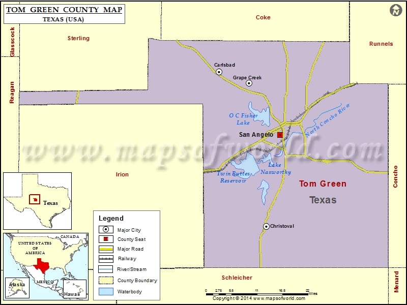
Check this Texas County Map to locate all the state’s counties in Texas Map.
Mountain Peaks in Tom Green County
| Mountain Peak/Hill | Elevation [Meter] |
|---|---|
| Allen Hill | 716 |
| Bean Hill | 698 |
| Brushy Knob | 717 |
| Cedar Knob | 717 |
| Devils Courthouse Peak | 683 |
| McLaughlin Mountain | 731 |
| Mount Nebo | 710 |
| Mountain Susan | 723 |
| Nasworthy Hill | 601 |
| Rattle Snake Hill | 623 |
| Ruby Point | 724 |
| Susan Peak | 717 |
| Twin Buttes | 615 |
More Maps of Green County
Airports in Tom Green County
| Airport Name |
|---|
| Brown Field |
| Charles J Hughes Ranch Airport |
| Ducote Airpark |
| Keystone Ranch Airport |
| Reece Field |
| San Angelo Regional Mathis Field |
| Shannon Medical Center Heliport |
Cities in Tom Green County
| City | Population | Latitude | Longitude |
|---|---|---|---|
| Carlsbad | 719 | 31.611248 | -100.640647 |
| Christoval | 504 | 31.197614 | -100.493302 |
| Grape Creek | 3154 | 31.581679 | -100.547371 |
| San Angelo city | 93200 | 31.440469 | -100.452243 |
Golf Courses in Tom Green County
| Name of Golf Course | Latitude | Longitude |
|---|---|---|
| Bentwood Country Club-San Angelo | 31.39745 | -100.479416 |
| Quicksand Golf Course-San Angelo | 31.470956 | -100.399485 |
| Riverside Hills Golf Course-San Angelo | 31.48524 | -100.467389 |
| San Angelo Country Club-San Angelo | 31.391092 | -100.442265 |
| Sante Fe Park Golf Course-San Angelo | 31.4609 | -100.448978 |
| Shooter’s Paradise-San Angelo | 31.354424 | -100.514278 |
 Wall Maps