- Florida Counties - Florida County Map, Maps of Florida Counties
- Major Cities of Florida - Miami, Ocala, St Augustine, Stuart, Tallahassee, Tampa, Venice, Jacksonville
- Neighbouring States - Alabama, Georgia, South Carolina, Louisiana, Mississippi
- Regional Maps - Map of USA
- Other Florida Maps - Florida Map, Where is Florida, Florida Airports Map, Florida Lat Long Map, Florida Zip Code Map, Florida Area Code Map, Florida National Parks Map
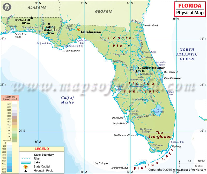
Florida Physical Map
Located in the southeastern region, the state of Florida is the 22nd most extensive of the 50 United States. Much of the state is situated on a peninsula that extends between the Gulf of Mexico and the Atlantic Ocean. It is the only state that borders the Atlantic Ocean as well as Gulf of Mexico. Florida is the third largest state by water area in the US, behind Alaska and Michigan.
The state is divided into four regions: Gulf Coast/Atlantic Ocean coastal plains, uplands of the north and northwest, the swampy Everglades, and the Florida Keys in the far south. The coastal plains generally feature flat terrain which is mostly fronted by barrier islands, beaches, and coral reefs. Florida Panhandle in West Florida features gently rolling hills near the boundaries of Alabama and Georgia. The Apalachicola River flows through the region. At only 105 meter (345 feet) above sea level, Britton Hill is the highest point in Florida and also the lowest highpoint of any state in the US.
The swampy and low-lying Everglades in South Florida comprises the largest subtropical wilderness in the US. The region is home to a wide array of animal and plant species. The Florida Keys is an archipelago including about 1,700 islands that extend in the Gulf of Mexico from the southeastern tip of the Florida peninsula. These islands along the Florida Straits define the southernmost portion of the continental US. Lake Okeechobee in Central Florida is the largest inland body of water in the state.
First Coast, Space Coast, and Gold Coast are sub-regions of the east coast of Florida while Emerald Coast, Forgotten Coast, and Nature Coast fall under the Gulf Coast of Florida.
Florida state has five geographical regions and they are Panhandle, North Florida, Central Florida, South Florida, Keys & Other Islands. The Panhandle region is the least populated. It has rolling, hilly terrain which resembles areas in Alabama or Georgia more than peninsular Florida. The highest point in Florida is located near Lakewood. The western Panhandle is in the central time zone. The sparsely populated North Florida region has national Wildlife Refuges and State Parks. North-central Florida has some of the state’s extraordinarily beautiful natural springs. Its Atlantic coast is highly developed though one can find quiet places too in the middle of the beach frenzy. The Central Florida region divides temperate and subtropical Florida and extends from coast to coast. Wildlife admirers may try canoeing to the gulf on the Chassahowitzka River or bird watching on Merritt Island National Wildlife Refuge which is an hour’s drive from Orlando. Along the Lake Wales Ridge, one can spot the last remnants of Florida’s scrub ecosystem. South Florida extends from Lake Okeechobee south to the tip of the peninsula. Its topography is more or less flat and most of it was wetlands hundred years ago. South Florida is where most of the state’s population lives. Beyond this is what remains of the upper Everglades. The climate here is tropical. The Florida Keys trail away to the southwest ending at Key West. It attracts a number of tourists in winters and its parks and reefs are usually very crowded.
 Wall Maps