Check this Washington County Map to locate all the state’s counties in Washington Map.
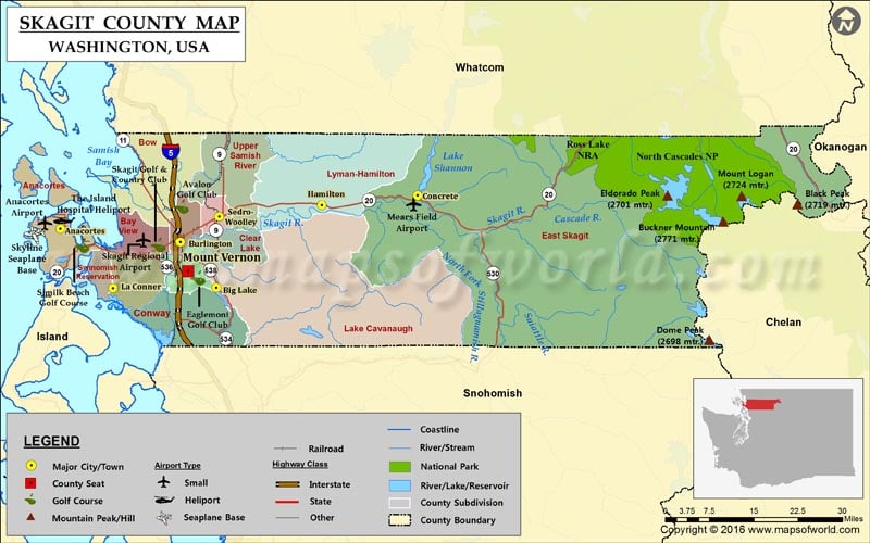
Skagit County is located in the Puget Sound region of Washington state. The county is named after the Native American Skagit tribe. Formed in 1883, it comprises an area of 1,920 square miles. The county seat and its largest city are Mount Vernon. The fertile Skagit River Valley is famous for the cultivation of tulips and strawberries.
There are three Indian reservations in the county: Swinomish, Upper Skagit, and Samish. Mount Buckner in the North Cascades is the highest point in Skagit County. Interstate 5, SR 9, and SR 20 are major highways in the county. Skagit Valley Tulip Festival, held annually in spring, is one of the most awaited events in Washington. The city of Anacortes on Fidalgo Island is a popular lay-by for travelers on their way to the San Juan Islands.
Facts about Skagit county in Washington |
|
|---|---|
| County Name | Skagit county |
| Population | 1,20,365 |
| Founded | 28 November 1883 |
| Area | 1,920 sq mi (4,973 sq km) |
| Land Area | 1,731 sq mi (4,483 sq km) |
| Water Area | 189 sq mi (490 sq km), 9.8% |
| Largest City | Mount Vernon |
| Cities | Mount Vernon, Anacortes, La Conner, Lyman, Burlington, Sedro-Woolley, Concrete, Hamilton |
| County Seat | Mount Vernon |
| Timezone | Pacific: UTC-8/-7 |
 Wall Maps