1.7K
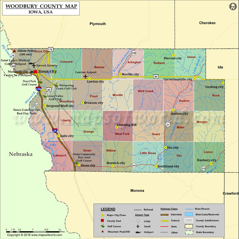
Mountain Peaks in Woodbury County
| Mountain Peak/Hill | Elevation [Meter] |
|---|---|
| Dakota Point | 390 |
Airports in Woodbury County
| Airport Name |
|---|
| Frevert Airstrip |
| Lawton Airport |
| Marian Health Center Nr 2 Heliport |
| Saint Luke’s Medical Center Heliport |
| Sioux Gateway Col. Bud Day Field |
Cities in Woodbury County
| City | Population | Latitude | Longitude |
|---|---|---|---|
| Anthon city | 565 | 42.388134 | -95.865633 |
| Bronson city | 322 | 42.409007 | -96.211358 |
| Climbing Hill | 97 | 42.339375 | -96.081086 |
| Correctionville city | 821 | 42.477185 | -95.78302 |
| Cushing city | 220 | 42.464969 | -95.675703 |
| Danbury city | 348 | 42.236432 | -95.721591 |
| Hornick city | 225 | 42.230464 | -96.097058 |
| Lawton city | 908 | 42.476917 | -96.185109 |
| Moville city | 1618 | 42.489425 | -96.067906 |
| Oto city | 108 | 42.282081 | -95.894549 |
| Pierson city | 366 | 42.542803 | -95.865277 |
| Salix city | 363 | 42.31511 | -96.302831 |
| Sergeant Bluff city | 4227 | 42.400264 | -96.355479 |
| Sioux City city | 82684 | 42.496315 | -96.391383 |
| Sloan city | 973 | 42.232475 | -96.22572 |
| Smithland city | 224 | 42.22896 | -95.931171 |
Golf Courses in Woodbury County
| Name of Golf Course | Latitude | Longitude |
|---|---|---|
| Anthon Golf Club-Anthon | 42.379553 | -95.875414 |
| Correctionville Golf Course-Correctionville | 42.483957 | -95.780733 |
| Floyd Park Golf Course-Sioux City | 42.468948 | -96.372568 |
| Green Valley Golf Club-Sioux City | 42.429226 | -96.356409 |
| Pierson Golf Course-Pierson | 42.547275 | -95.868449 |
| Sioux City Country Club-Sioux City | 42.537868 | -96.402805 |
| Sloan Community Recr Assn Golf Course-Sloan | 42.239504 | -96.234923 |
| Sun Valley Golf Course-Sioux City | 42.515272 | -96.435072 |
| The Meadows Country Club-Moville | 42.493627 | -96.056344 |
| Whispering Creek Golf Club-Sioux City | 42.459412 | -96.313097 |
 Wall Maps