1.7K
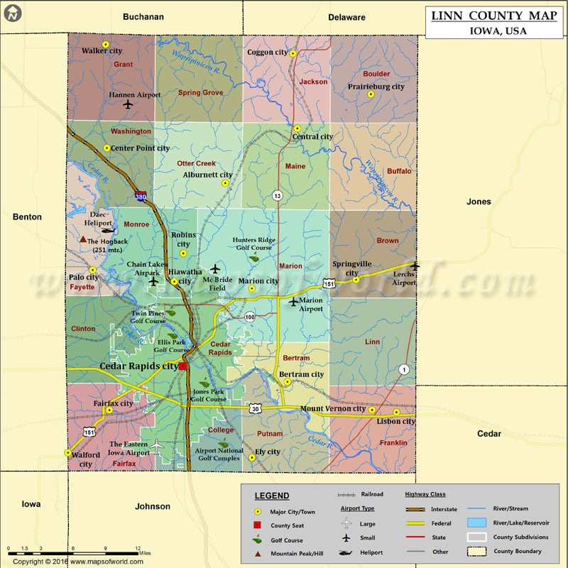
Mountain Peaks in Linn County
| Mountain Peak/Hill | Elevation [Meter] |
|---|---|
| The Hogback | 251 |
Airports in Linn County
| Airport Name |
|---|
| Chain Lakes Airpark |
| Daec Heliport |
| Downtown Heliport |
| Hannen Airport |
| Lerchs Airport |
| Marion Airport |
| Mays Island Helistop |
| Mc Bride Field |
| Mercy Hospital Heliport |
| St Anthony Regional Hospital Heliport |
| St Lukes Hospital Emergency Heliport |
| The Eastern Iowa Airport |
Cities in Linn County
| City | Population | Latitude | Longitude |
|---|---|---|---|
| Alburnett city | 673 | 42.149301 | -91.620917 |
| Bertram city | 294 | 41.951133 | -91.53764 |
| Cedar Rapids city | 126326 | 41.966729 | -91.678168 |
| Center Point city | 2421 | 42.184301 | -91.779437 |
| Central City city | 1257 | 42.203745 | -91.524468 |
| Coggon city | 658 | 42.278306 | -91.530367 |
| Ely city | 1776 | 41.875346 | -91.585038 |
| Fairfax city | 2123 | 41.92274 | -91.775873 |
| Hiawatha city | 7024 | 42.051025 | -91.688981 |
| Lisbon city | 2152 | 41.920532 | -91.391662 |
| Marion city | 34768 | 42.044365 | -91.585326 |
| Mount Vernon city | 4506 | 41.922976 | -91.424349 |
| Palo city | 1026 | 42.06271 | -91.798215 |
| Prairieburg city | 178 | 42.237735 | -91.425836 |
| Robins city | 3142 | 42.079273 | -91.676834 |
| Springville city | 1074 | 42.052954 | -91.445735 |
| Walford city | 1463 | 41.88022 | -91.831441 |
| Walker city | 791 | 42.287313 | -91.780874 |
Golf Courses in Linn County
| Name of Golf Course | Latitude | Longitude |
|---|---|---|
| Airport National Golf Complex-Cedar Rapids | 41.889946 | -91.623288 |
| Cedar Rapids Country Club-Cedar Rapids | 42.003441 | -91.628174 |
| Donald K. Gardner Memorial Golf Course-Marion | 42.013435 | -91.557818 |
| Ellis Park Golf Course-Cedar Rapids | 41.998932 | -91.691342 |
| Elmcrest Country Club-Cedar Rapids | 42.01488 | -91.648507 |
| Hillcrest Country Club-Mount Vernon | 41.915241 | -91.409754 |
| Hunters Ridge Golf Course-Marion | 42.075855 | -91.582228 |
| Jones Park Golf Course-Cedar Rapids | 41.950526 | -91.648976 |
| Meadowridge Golf Drving Range-Cedar Rapids | 41.963941 | -91.757448 |
| Meadowview Country Club-Central City | 42.202749 | -91.512846 |
| Olde Indian Creek Country Club-Marion | 42.046715 | -91.59449 |
| Rolling Acres Golf Course-Center Point | 42.207899 | -91.805387 |
| St. Andrews Golf Club-Cedar Rapids | 42.035059 | -91.66454 |
| Twin Pines Golf Course-Cedar Rapids | 42.021808 | -91.694142 |
 Wall Maps