4.8K
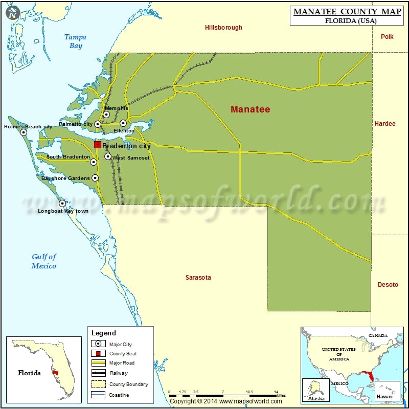
Check this Florida County Map to locate all the state’s counties in Florida Map.
Mountain Peaks in Manatee County
| Mountain Peak/Hill | Elevation [Meter] |
|---|---|
| Portavant Indian Mound | 1 |
Airports in Manatee County
| Airport Name |
|---|
| Airport Manatee Airport |
| Hca L.W. Blake Hospital Heliport |
| Lakewood Ranch Medical Center Helistop Heliport |
| Manatee Memorial Hospital Heliport |
| Myakka Head Airport |
| Sarasota Bradenton International Airport |
| Southfork Airport |
| Thomson Airfield |
Cities in Manatee County
| City | Population | Latitude | Longitude |
|---|---|---|---|
| Anna Maria city | 1503 | 27.529707 | -82.734098 |
| Bayshore Gardens | 16323 | 27.434552 | -82.579359 |
| Bradenton Beach city | 1171 | 27.46519 | -82.696179 |
| Bradenton city | 49546 | 27.490069 | -82.57493 |
| Cortez | 4241 | 27.466827 | -82.668788 |
| Ellenton | 4275 | 27.526438 | -82.526293 |
| Holmes Beach city | 3836 | 27.510856 | -82.715295 |
| Longboat Key town | 6888 | 27.391171 | -82.635524 |
| Memphis | 7848 | 27.54101 | -82.558323 |
| Palmetto city | 12606 | 27.524748 | -82.574628 |
| Samoset | 3854 | 27.476446 | -82.542876 |
| South Bradenton | 22178 | 27.461067 | -82.582034 |
| West Bradenton | 4192 | 27.501702 | -82.614677 |
| West Samoset | 5583 | 27.470257 | -82.555184 |
| Whitfield | 2882 | 27.411541 | -82.565995 |
Golf Courses in Manatee County
| Name of Golf Course | Latitude | Longitude |
|---|---|---|
| Bradenton Country Club-Bradenton | 27.492426 | -82.608803 |
| Buffalo Creek Golf Course-Palmetto | 27.551519 | -82.548097 |
| Heather Hills Golf Course-Bradenton | 27.462194 | -82.563269 |
| IMG Academies Golf & Country Club-Bradenton | 27.428957 | -82.604813 |
| Imperial Lakewoods Golf Club-Palmetto | 27.599153 | -82.502687 |
| Key Royale Club-Holmes Beach | 27.525369 | -82.714379 |
| Lakewood Ranch Golf and Country Club-Bradenton | 27.403029 | -82.405985 |
| Legacy Golf Club-Bradenton | 27.389814 | -82.416636 |
| Links At Greenfield Plantation-Bradenton | 27.491014 | -82.438533 |
| Manatee County Golf Course-Bradenton | 27.448106 | -82.623718 |
| Palm Aire Country Club of Sarasota-Sarasota | 27.404752 | -82.490885 |
| Palm View Hills Golf Course-Palmetto | 27.56495 | -82.535766 |
| Palmetto Pines Golf Course-Parrish | 27.555764 | -82.397174 |
| Peridia Golf & Country Club-Bradenton | 27.453923 | -82.509574 |
| Pinebrook/Ironwood Golf Course-Bradenton | 27.464482 | -82.610903 |
| Ritz Carlton Members Golf Club-Bradenton | 27.413691 | -82.388581 |
| River Isles Golf Club-Bradenton | 27.491858 | -82.510279 |
| River Run Golf Links-Bradenton | 27.483001 | -82.530103 |
| River Strand Golf and Country Club-Bradenton | 27.508399 | -82.469372 |
| River Wilderness Golf & Country Club-Parrish | 27.534705 | -82.437872 |
| Rosedale Golf & Tennis Club-Bradenton | 27.44638 | -82.452084 |
| Stoneybrook Golf Club At Heritage Harbour-Bradenton | 27.491783 | -82.464212 |
| Suncoast Golf Center-Sarasota | 27.402618 | -82.546643 |
| Tara Golf & Country Club-Bradenton | 27.439864 | -82.478118 |
| Terra Ceia Golf & Country Club-Palmetto | 27.538404 | -82.583243 |
| The Concession Golf Club-Bradenton | 27.393537 | -82.330117 |
| The Preserve Golf Club At Tara-Bradenton | 27.432788 | -82.466621 |
| The River Club-Bradenton | 27.423301 | -82.433123 |
| Timber Creek Golf Course-Bradenton | 27.459854 | -82.623402 |
| University Park Country Club-University Park | 27.404379 | -82.475755 |
| Waterlefe Golf & River Club-Bradenton | 27.516288 | -82.441525 |
National Parks in Manatee County
| Name of Park | Latitude | Longitude |
|---|---|---|
| De Soto National Memorial NM | 27.523042 | -82.643619 |
 Wall Maps