logo


Greenland Latitude and Longitude Map

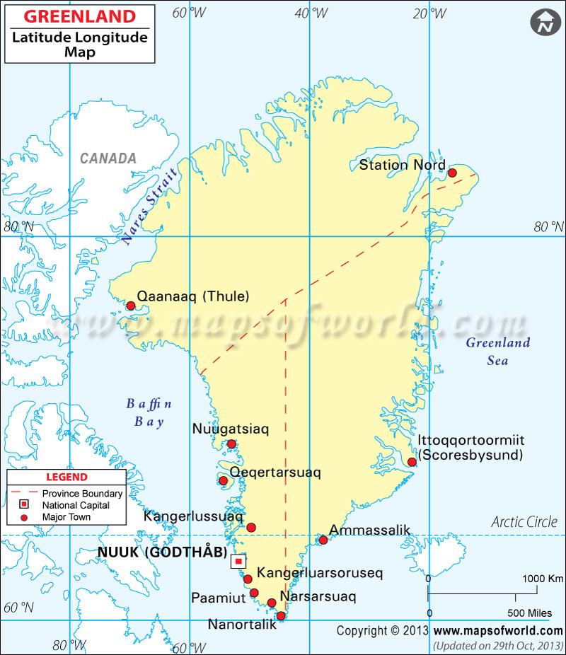
Greenland's latitude and longitude is 72° 00' N and 40° 00' E . Below is the map of Greenland showing major towns, roads, airports with latitudes and longitudes plotted on it.
Greenland Latitude and Longitude Map
Canada Latitude and Longitude Map Canada Latitude and Longitude Map Canada Latitude and Longitude Map Iceland Latitude and Longitude Map
Description : Map shows the latitude and longitude of Greenland municipalities, cities and towns. Disclaimer
×

Disclaimer  :  All efforts have been made to make this image accurate. However MapSherpa, Inc, its directors and employees do not own any responsibility for the correctness or authenticity of the same.


Search For Latitude & Longitude Map

By Country

Or

Latitude

Longitude

Or

Area

* Put South & West values with minus ( - ) sign.


The latitude and longitude of Greenland is 72º 00' N and 40º 00' E respectively. It is located on the northern part of North America and lies between Arctic Ocean and North Atlantic Ocean.

The total area is slightly more than three times that of Texas. Greenland comprises of three administrative districts and eighteen municipalities. Nuuk, the Capital of Greenland is located on 64º 11' N and 51º 44' W latitude and longitude respectively. Greenland is 2 hours ahead of Washington DC during Standard Time and is divided into four time zones.

The total area of Greenland is 2,166,086 square kilometers and the coastline extends for 44,087 kilometers. The terrain of the region is flat but gradually sloping icecap covers almost all parts except a narrow rocky coast. The climate of Greenland is that of arctic of sub arctic type with cool summers and winters. Continuous permafrost over the northern two-third parts of the island is the greatest natural hazard of the region. Greenland is regarded as the world's second largest ice cap.


Latitude and Longitude of Gibraltar

LocationLatitudeLongitude
Alluitsup Paa60°30'N45°35'W
Ammassalik/Tasiilaq65°40'N37°20'W
Angmagssalik/Tasiilaq65°40'N37°20'W
Brewster Kap/Kangikajik70°07'N22°00'W
Disko/Qeqertarsuaq69°45'N53°30'W
Disko Bugh69°10'N52°00'W
Farewell C./Nunap Isua59°48'N43°55'W
Farvel, Kap/Nunap Isua59°48'N43°55'W
Forel, Mt.66°52'N36°55'W
Frederikshab/Paamiut62°00'N49°43'W
Godhavn/Qeqertarsuaq69°15'N53°38'W
Godthab/Nuuk64°10'N51°35'W
Gunnbjorn Fjeld68°55'N29°47'W
Humboldt Gletscher79°30'N62°00'W
Independence Fjord82°10'N29°00'W
Ittoqqortoormiit70°20'N23°00'W
Julianehab/Qaqortoq60°43'N46°00'W
Kane Basin79°01'N70°00'W
Kangikajik70°07'N22°00'W
Kajserr Franz Joseph Fd.73°30'N24°30'W
King Frederick VI Land/Kong Frederik VI Kyst63°00'N43°00'W
 
LocationLatitudeLongitude
Kong Christian IX Land68°00'N36°00'W
Kong Christian X Land74°00'N29°00'W
Kong Frederik IX Land67°00'N52°00'W
Kong Frederik VI Kyst63°00'N43°00'W
Kong Frederik VIII Land78°30'N26°00'W
Kong Oscar Fjord72°20'N24°00'W
Nunap Isua59°48'N43°55'W
Nuuk64°10'N51°35'W
Paamiut62°0'N49°43'W
Peary Land82°40'N33°0'W
Petermann Bjerg73°07'N28°25'W
Quaanaaq77°40'N69°0'W
Qaanaaq77°40'N69°0'W
Qaqortoq60°43'N46°0'W
Qeqertarsuaq 69°15'N53°38'W
Qeqertarsuaq 69°45'N53°30'W
Robeson Chan 82°0'N61°30'W
Scoresbysund/
Ittoqqortoormiit
70°20'N23°0'W
Smith Sund78°30'N74°0'W
Tasiilaq65°40'N37°20'W
Upernavik72°49'N56°20'W
York Kap. 75°55'N 6°25'W


Last Updated on: November 14th, 2017