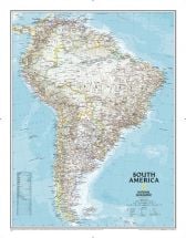
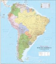
Countries in South America
South America is home to twelve countries, each offering its own distinctive culture, landscapes, and history. For the individual map of each country, click on the country name in the below table.
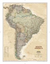
Geography of South America
South America is bound by the Caribbean Sea in the north, the North Atlantic Ocean in the east and northeast and by the South Atlantic Ocean in the southeast. The South Pacific Ocean borders the continent in the west. In the northwest, the Isthmus of Panama joins South America with
North America.
South America sustains a stunning variety of landscapes from desert to rainforest, and from plains to hills.
Here are some quick geographical facts about the continent:
- The world's highest uninterrupted waterfall, Angel Falls is located in Venezuela.
- The highest single drop waterfall, Kaieteur Falls is located in Guyana.
- The largest river by volume in the entire world is the Amazon River
- The longest mountain range is the Andes, stretching upto 4,300 miles.
- The driest non-polar desert, the Atacama Desert is also situated here.
- It is also home to the the largest rain-forest, the Amazon Rainforest.
- The highest capital city is La Paz, in Bolivia.
- Lake Titicaca – the highest commercially navigable lake in the world is located in South America.
- Permanently inhabited southernmost point of this world – Puerto Toro in Chila is a part of the continent.
- Gold, silver, copper, iron ore, tin, and petroleum – the major mineral resources found here, have helped in establishment of economies in the countries of the continent.
- Plenty of unique species of animals are inhabited here, including the llama, anaconda, piranha, jaguar, vicuña, and tapir.
Demographics of South America
The continent sustains 4.20 billion population, as per 2016 estimates. Half of the population lives in Brazil. Diverse ethnic groups live in the continent. Owing to the long history of colonialism, majority population speaks Portuguese and Spanish. The other native languages here are English, French, Dutch, Quechua, Hindustani, Sranan Tongo and Saramaccan. As per the estimations, about 90% of South Americans are Christians – out of which 82% is Roman Catholic and 8% are Protestants or Evangelicals. However, Judaism, Japanese Buddhism, Shintoism etc are also observed in dominance in few cities. Societies and states mostly reflect the Western traditions and culture.
History of South America
South America has a long history, dating back to the first human settlements across the Bering Land Bridge, about 15,000 years ago. The earliest evidence of human race existence is from 9000BC when chill peppers, beans and squash cultivation began for food requirements. Numerous agrarian communities established themselves in Andes by the 2000 BC. Migrations from North America to South America occurred using the Isthmus of Panama.
One of the earliest civilizations settled in Norte Chico. Around the 7th century, Huari Empire was expanded on the Andean region.
Other pre-Columbian empires included:
- the Cañaris (in south central Ecuador)
- Chimú Empire (Peruvian northern coast)
- Chachapoyas
- the Aymaran kingdoms (Western Bolivia and southern Peru)
- Inca Empire
Inca empire is one of the ancient empires that is popular in the world for a number of reasons. Inca empire was a civilization that was incredibly prosperous and still amazes today's world with a number of architectural and cultural wonders that was a part of their colorful civilization. Inca empire or the Inca civilization originated in the South America and more precisely in the country of Peru.
A number of other South American countries are also the proud possessors of many of the artifacts of this Inca empire.The Inca empire of the South America was in their zenith during 1200 to 1535 AD. But this civilization could not survive the colonizers, specially the Spaniards and dissipated gradually.
However, within the time that may be said to be the pick of this great civilization, Inca empire has already left a number of amazing marks for the world to be amazed with. It was a race that was mainly a warrior class of people.
In their society the highest position was of a priest or the army general. The other people had to abide by the social rules and regulations set by them. People had a high place of their religion and gods. The highest place of a city or village used to be reserved for the temple.Moreover, most of the Inca cities and residents were built in hilly area and still boast of amazing architectural progress. The Inca Empire with a number of distinctive features related with every aspects of life, is still a very interesting civilization to know about.
In 1492, Christopher Columbus discovered the "New World", and the number of Spanish explorers increased between 1496 and 1526. In 1533, the Spanish Army led by Francisco Pizarro had captured much of Inca territory. In the period between 1535 and 1537, Argentina, Peru, and Bolivia were founded, and by the eighteenth century the Spanish colonies in South America started to make a serious bid for independence. While fighting wars against France on the European mainland, Spain began to lose control of its South American colonies, and by the end of the war in 1814, countries like Argentina and Venezuela gained their independence from Spain, and other nations followed suit. In the twentieth century, several South American countries, including Peru and Venezuela, had held elections for the first time after their independence.
South America Economy
The manufacturing industries, agriculture, and trade primarily support the economy of South America. The economies of many South American countries are based on export of goods, primarily the export of agricultural products. Brazil and Argentina lead in the export of goods to other nations. Some of the major agricultural products include sugarcane, corn, wheat, soybean, and coffee. South America's mineral resources also contribute substantially to the economy. Some major mineral resources found in South America are petroleum, gold, iron ore, silver, and copper.
South America has a rapidly developing economy. With many industries and a flourishing trade and import-export market, it is fast becoming a economy with considerable size.
South American countries had a slow pace of economic development in the past. In recent times, however, South America has as a whole undergone rapid economic development. Aided by greater economic independence since the times of the second World War, South America has been largely successful in developing its economy rapidly.
The biggest individual economies in South America are those of Brazil, Argentina, Colombia and Chile.
Currently undergoing massive growth are the economies of Argentina, Venezuela and Peru. Major industries in South America are agriculture, which encompasses a vital part of the economy, and other important industries like fishing, natural resources, handicrafts etc. Trade is also an important part of the economy.
For more information log on to
South America Travel and Tourism
Tourism is another important industry in South America that not only enhances the GDP of each country, but also ensures greater job opportunities. The historical sites, architectural marvels, and the natural landscapes of the continent attract millions of tourists every year from all across the globe.
South America is a land of diversity. The
Amazon Rainforest and
Amazon River, the Atacama Desert, Lake Titicaca, and Angel Falls of Venezuela are some of the major natural attractions of South America. South America has diverse climates from dry and arid to tropical.