logo


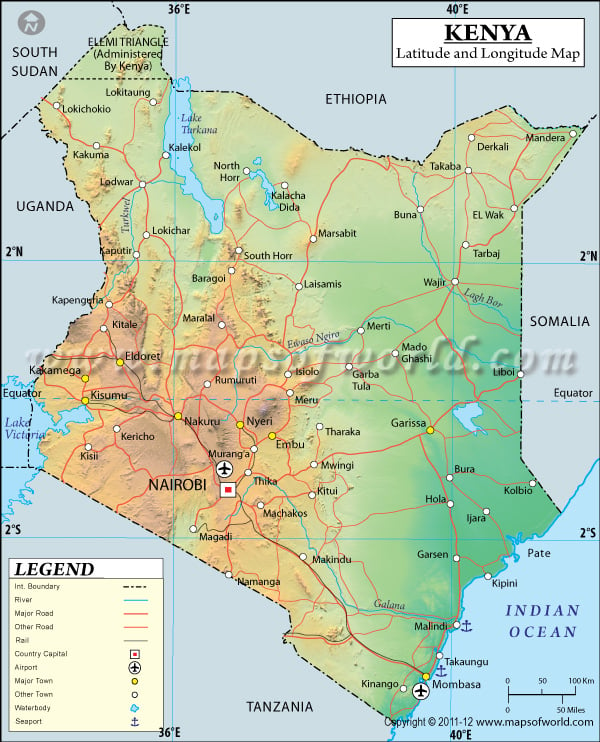
Kenya Latitude and Longitude Map

Kenya's latitude and longitude is 1° 00' N and 38° 00' E . Below is the map of Kenya showing major towns, roads, airports with latitudes and longitudes plotted on it.
Kenya Latitude and Longitude Map South Sudan Lat Long Map Ethiopia Lat Long Map Somalia Lat Long Map Tanzania Lat Long Map Uganda Lat Long Map
Description : :Find Kenya latitude and longitude map showing comprehensive details including cities, roads, towns, airports and much more. Disclaimer
×

Disclaimer  :  All efforts have been made to make this image accurate. However MapSherpa, Inc, its directors and employees do not own any responsibility for the correctness or authenticity of the same.


Search For Latitude & Longitude Map

By Country

Or

Latitude

Longitude

Or

Area

* Put South & West values with minus ( - ) sign.


The Republic of Kenya has its geographic location in Eastern Africa with latitude of 1°00'N and a longitude of 38°00'E.

In Swahili, Kenya is also known as Jamhuri ya Kenya. Being the Forty Seventh largest country in terms of land area, the latitude and longitude of Kenya covers an area of 582,650 sq km. The capital of Kenya is Nairobi and its geographic coordinates are 1°16'S latitude and 36°48'E longitude. Other important cities having their geographic location in Kenya are Mombasa and Kisumu.

Kenya has been independent from foreign rule since 1963. The founding president and patriot Jomo Kenyatta was the first chief executive who came into power. The population of Kenya is 36,913,721 and the majority of Kenyans are part of the Kikuyu tribe. Other tribes like the Luhya, Luo, Kalenjin, Kamba etc compose the rest of the population.

The Geographic location of Kenya is responsible for the tropical climate in the area, there are changes in weather as one moves into the arid interiors from the coastal regions. The Geographic coordinates of Kenya place it among the African low lands and the Great Rift Valley in the Central African Highlands. Kenya has sizable wildlife habitat areas, including the Masai Mara lands. The Blue Wildebeest, typical of the region participates in the annual migration stampedes.


Latitude and Longitude of Kenya

LocationLatitudeLongitude
Aberdare Ra.,00°15'S36°50'E
Amboseli, L.,02°40'S37°10'E
Archers Post00°35'N37°35'E
Baringo00°47'N36°16'E
Baringo, L.00°47'N36°16'E
Buna02°58'N39°30'E
Bungoma00°34'N34°34'E
Bura01°04'S39°58'E
Central00°30'S37°30'E
Central I.03°30'N36°00'E
Cheptulil, Mt.01°25'N35°35'E
Choba02°30'N38°05'E
Coast02°40'S39°45'E
Danissa03°15'N40°58'E
Eastern00°00'N38°30'E
El Wak02°49'N40°56'E
Eldoret 00°30'N35°17'E
Embu00°32'S37°38'E
Formosa Bay02°40'S40°20'E
Galana03°09'S40°08'E
Garba Tula00°30'N38°32'E
Garissa00°25'S39°40'E
Garsen02°20'S40°05'E
Gilgil00°30'S36°20'E
Habaswein01°02'N39°30'E
Homa Bay00°36'S34°30'E
Isiolo00°24'N37°37°33'E
Kajiado01°53'S36°48'E
Kakamega00°20'N34°46'E
Kaputir02°05'N35°28'E
Karungu00°50'S34°10'E
Katungu02°55'S40°03'E
Kenya, Mt.00°10'S37°18'E
Kericho00°22'S35°15'E
Kiambu01°08'S36°50'E
Kibwezi02°27'S37°57'E
Kilifi03°40'S39°48'E
Kilindini04°04'S39°40'E
Kipini02°30'S40°32'E
Kirinyaga/Kenya, Mt.00°10'S37°18'E
Kisii00°40'S34°45'E
Kisumu00°03'S34°45'E
Kitale01°00'N35°00'E
Kitui01°17'S38°00'E
Konza01°45'S37°07'E
Kulal, Mt.02°42'N36°57'E
Kwale04°15'S39°31'E
Lamu02°16'S40°55'E
Limuru01°02'S36°35'E
Lodwar03°10'N35°40'E
Lokichokio04°19'N34°13'E
Lokitaung04°12'N35°48'E
Londiani0°10'S35°33'E
 
LocationLatitudeLongitude
Lugard's Falls03°06'S38°41'E
Lumbwa0°12'S35°28'E
Machakos01°30'S37°15'E
Mackinnon Road03°40'S39°01'E
Magadi 10°54'S36°19'E
MagadiL.01°54'S36°19'E
Makindu02°18'S37°50'E
Malindi0°.12'S40°05'E
Mambrui03°05'S40°50'E
Mandera03°55'N41°53'E
Maralal01°0'N36°38'E
Marenyl04°22'S39°08'E
Mariakani03°50'S39°27'E
Mau Escarpment0°10'S36°0'E
Meru0°03'N37°40'E
Mombasa04°02'S39°43'E
Moroto Summit 02°30'N34°43'E
Moyale 03°30'N39°0'E
Murang'a0°45'S37°09'E
Murka03°27'S38°0'E
Nairobi01°17'S36°48'E
Naivasha 0°40'S36°30'E
Naivasha L.0°48'S36°20'E
Nakuru0°15'S36°04'E
Nanyuki 0°02'N37°04'E
Narok01°55'S35°52'E
Ndoto Mts.02°0'N37°0'E
North Eastern01°30'N40°0'E
North Horr03°20'N37°08'E
North I. 04°05'N36°05'E
Nyahururu 0°02'N36°27'E
Nyanza0°10'S34°15'E
Nyeri0°23'S36°56'E
Patta02°10'S41°0'E
Pelekech03°52'N35°08'E
Rabai03°50'S39°31'E
Rumuruti0°17'N36°32'E
Sasumua Dam0°45'S36°40'E
Solai0°2'N36°12'E
South Horr2°12'N36°56'E
South I. 2°35'N36°35'E
Taita Hills3°25'S38°15'E
Tana 2°32'S40°31'E
Thika1°1'S37°5'E
Timau0°4'N37°15'E
Turkwel3°6'N36°6'E
Voi3°25'S38°32'E
Wajir1°42'N40°5'E
Wangi1°58'S40°58'E
Western 0°30'N 34°30'E
Einam G.0°20'S 34°15'E
Yatta Plateau2°0'S 38°0'E


Last Updated on: November 17th, 2017