The
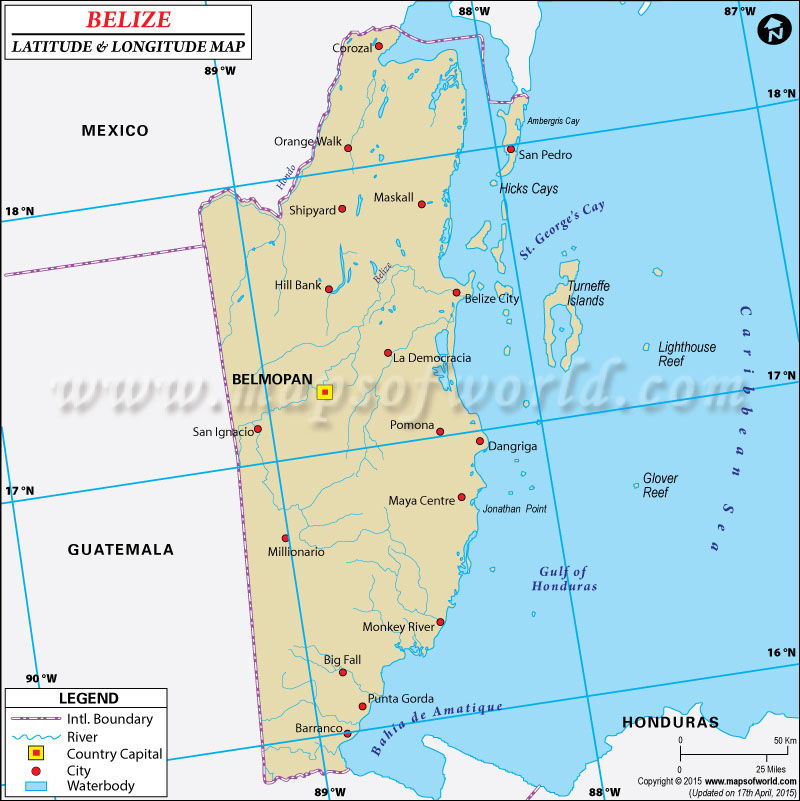
latitude and longitude of Belize is 17° 15' North and 88° 45' West. Belize is a Central American country located by the Caribbean Sea.
The area which falls within the above mentioned
longitude and latitude of Belize is about 22,966 square kilometers.
The country of Belize in the Northern hemisphere is comparatively a small country with two big neighbors like Mexico and Guatemala. The latitude of Belize falls between the equator and the Tropic of Cancer thus the climatic condition is mostly tropical.
It should be kept in mind that the climatic conditions are different in the region near the Caribbean Sea and the Guatemala mountains. As the longitude of Belize is 88° 45' West the time zone is UTC-6 which is 1 hour behind the standard time of Washington DC.
Latitude and Longitude of Belize |
|---|
| Location | Latitude | Longitude |
|---|
| Ambergris Cay | 18°00'N | 88°00'W |
| Belize City | 17°25'N | 88°00'E |
| Belmopan | 17°18'N | 88°30'W |
| Benque Viejo | 17°05'N | 89°08'W |
| Corozal | 18°23'N | 88°23'W |
| Dangriga | 16°96'N | 88°21'W |
| Hondo | 18°25'N | 88°21'W |
| Maya Mts | 16°30'N | 89°00'W |
| Midlesex | 17°02'N | 88°31'W |
| Monkey River | 16°22'N | 88°29'W |
| Orange Walk | 18°06'N | 88°33'W |
| Punta Gorda | 16°10'N | 88°45'W |
| San Antonio | 16°15'N | 89°2'W |
| Turneffe Is. | 17°20'N | 87°50'W |
Last Updated on: November 9th, 2017


